Backpack: Big Sandy to Elkhart Park via Fremont and Highline Trails
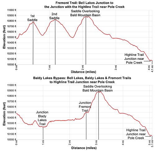
Segment 7: Bell Lakes Junction to Pole Creek
Distance: 4.1 - 5.1 miles (one way)
Bridger Wilderness, Bridger-Teton National Forest, near Big Sandy in Wyoming's Wind River Range
By: Diane Greer
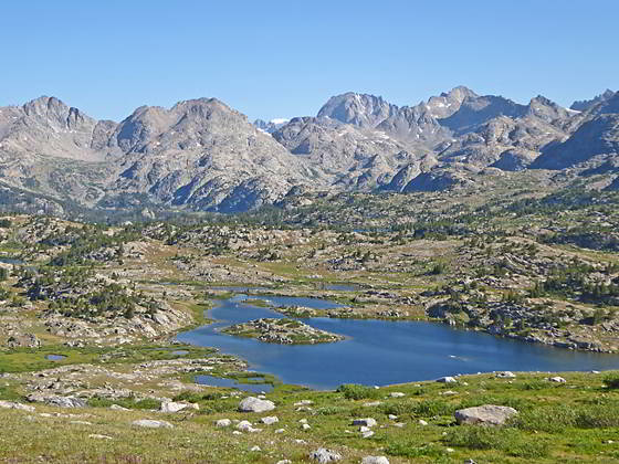
Bald Mountain Basin Close-up
- Distance: 4.1 - 5.1 miles
- Elevation: 10,470-ft. at Junction Bell Lakes /Fremont Trail
10,765 at the top of the 1st ridge
10,540-ft. at low point
10,820 at the top of the 2nd ridge
10,495-ft. at low point
10,860 at the ridge overlooking Bald Mountain Basin
10,065 at the Junction with the Highline Trail - Difficulty: strenuous
- Basecamp: Big Sandy / Elkhart Park
- Region: Wyoming's Wind River Range
Bell Lakes Junction to Pole Creek Description
This description starts at the four-way junction of the Fremont Trail with the Bell Lakes and Timico Lake trails. Here the Bell Lakes trail branches to the left (west) and leads to the Baldy Lakes trail and the Chain Lakes (located along the Highline trail). To the right (northeast) the Timico Lakes Trail heads across the meadows to Timico Lake (10,512-ft.).
The Fremont Trail continues straight ahead (northwest) toward the Cook Lakes, crossing three high ridges over the next 2.1 miles. The demanding trail ascends 300-ft. to a saddle (10,765-ft.) on the first ridge and then loses 225-ft. before climbing 280-ft. to the second ridge crest (10,820-ft.). The final trail segment loses 325-ft. and then climbs 360-ft. to the saddle (10,860-ft.) atop the ridge overlooking Bald Mountain Basin.
Many backpackers find this section of the trail tedious and tiring. An alternative route that avoids the first two ridges drops down the Bell Lakes trail and then turns right (north) on the Baldy Lakes trail, which leads back to the Fremont Trail near the low point before the climb to the ridge overlooking Bald Mountain Basin. This route is 1.0 mile longer but is considered easier.
I have done both routes and honestly don’t think there is that much of a difference. Visiting the Baldy Lakes to camp and fish is a good option at the end of a long day. The lakes, which you can’t see until you ascend 0.5 miles up the lake basin, are pretty but not scenic standouts when compared to other lake basins along the Fremont Trail. Alternatively, tackling the three ridges along the Fremont is more strenuous but involves less mileage. The trail is also more scenic, offering nice views of the surrounding peaks. So take your pick, depending on the time of day and your energy level.
For those who love numbers, the segment of the Fremont trail over the two saddles gains a total of 622-ft. and loses 597-ft. over 1.6 miles (as measured with a GPS that tabulated all the ups and downs). The route through the Baldy Lake gains a total of 582-ft. and loses 555-ft. in 2.6 miles. Not much of a difference although the Baldy Lakes gains/losses are easier since they are spread out over a longer distance. You will still need to climb 360-ft. to the saddle on the ridge overlooking Bald Mountain Basin regardless of which route you select. Both routes are described below.
Fremont Trail: Bell Lakes Junction to the Junction with the Highline Trail near Pole Creek
From the junction with Bell Lakes and Timico Lake trails, the Fremont Trail heads northwest climbing on moderate grades through clusters of trees and meadows set amid granite knobs and outcroppings. As the path gains elevation the trees give way to rocky meadows sprinkled with lupines. Along the way good views open to the peaks rising above the Timico Lake basin to the east/southeast.
As the trail crests the first ridge at 0.5 miles Mt. Baldy (11,857-ft.) springs into view to the northwest. On a clear day the saddle (10,765-ft.) enjoys distant views of Peak 11740, Ellingwood Peak (13,052) (aka Harrower Peak) and Fremont Peak (13,745-ft.) rising above the ridges to the north. Nearer at hand are the peaks towering above the Timico Valley.
Descend the ridge on moderately steep grades, traveling through pretty meadows sprinkled with wildflowers, willows and small conifers. After losing 225-ft. the trail skirts the west side of a marshy meadow and then starts the steep climb up the next ridge. As you ascend the trail curves around a rock outcropping and then climbs a draw, staying to the west of a small stream. Soon the trail reaches the broad saddle atop the second ridge at 1.2 miles. Here Mt. Baldy dominates the view to the west. In the distance the summit of Mt. Lester (12,342-ft.) peeks above the ridge to the north.
The path now descends on moderate to moderately-steep grades to boggy meadows at the base of the ridge. Along the way views open to the Baldy Lakes nestled in a basin beneath Mt. Baldy.
At 1.6 miles cross a steam that is draining the boggy meadows. A short distance beyond the stream, reach a pole marking the junction with the Baldy Lakes trail branching to the left (southwest). If you are looking to camp there are some nice sites in the Baldy Lakes basin above the upper lake’s eastern shores.
Soon the trail starts climbing steeply through meadows and then rocky slopes along the east side of a draw toward the top of the third ridge. Depending on the time of year a stream draining snowmelt from the upper slopes trickles down the draw. Near the top of the climb you may need to cross a small stream or slog up snow covered slopes.
As you crest the saddle on the ridge at 2.1 miles stunning views unfold to the high peaks rising to the north. Cross to the alpine meadows atop the broad ridge to the north side of the saddle for the best views. Here Mt Lester, Peak 11740, Fremont Peak, Ellingwood Peak and the unnamed summits above Bald Mountain basin fill the skyline. If you have a zoom lens or binoculars you should be able to see Mt. Woodrow Wilson (13, 502-ft.) and Gannett Peak (13,804-ft.) rising to the north/northwest of Fremont Peak.
After taking a break and enjoying the fine views, descend the north side of the ridge on moderate grades through meadows. Soon views open to lakes nestled among rocky knobs in beautiful Bald Mountain basin. Distinctively shaped Angel Peak (12,402-ft.) and Angel Pass dominate the view to the northeast. Lester Pass is now visible on the ridge to the west of Mount Lester.
The basin is a great place to find a secluded campsite with terrific views. Spend some time studying the basin as you descend, planning where you want to leave the trail to find a campsite. Navigating a cross-country route through the basin is easier if you get a lay of the land from above.
The grade abates as the trail enters Bald Mountain Basin at 2.7 miles. The path now weaves through meadows and willow thickets growing amid rock outcroppings. Lakes of varying sizes lie cradled in a maze of rocky knobs. Clusters of spruce and pine trees grow atop the knobs and between rock outcroppings.
At 3.0 miles the trail crosses to the east side of a small stream and then curves to the left (northwest). Cross to the west side of a second stream at 3.3 miles. Beyond the crossing the trail descends along the southwest side of the stream to a marshy basin where the path crosses back to the east side of the stream at 3.6 miles. The path now enters the trees and drops down a hillside on moderate grades.
Near the base of the hill the trail emerges from the trees and crosses a meadow littered with willow thickets. On the north side of the meadow the path reenters the trees and drops steeply down a hillside to the beautiful meadows near Pole Creek, reaching the junction with the trail to the Cook Lakes, branching right (northeast), at 4.0 miles.
As short distance beyond the Cook Lakes intersection reach the junction with the Highline Trail at 4.1 miles. This junction marks the end of the Fremont Trail. Here the southbound Highline trail branches left (west) and descends along the south/southeast side of Pole Creek toward the Pole Creek Lakes and the Pole Creek Trail. We continue straight ahead (northwest) on the northbound Highline toward Lester Pass and Little Seneca Lake.
Baldy Lakes Bypass: Bell Lakes, Baldy Lakes and the Fremont Trails to the Junction with the Highline Trail near Pole Creek
- Distance: 5.1 miles
- Trailhead Elevation: 10,470-ft. at Junction Bell Lakes /Fremont Trail
10,207 at Junction Baldy Lakes Trail
10,360-ft. at Baldy Lakes
10,860 at the ridge overlooking Bald Mountain Basin
10,060 at the Junction with the Highline Trail - Difficulty: strenuous
From the junction with the Fremont and Timico Lake trails, the Bell Lake trail heads left (west), descending through meadows and trees on easy to moderate grades. Initially the path is faint but soon becomes better defined. At 0.6 miles the trail starts a climb over a low wooded ridge, passing to the north of a small pond at the ridge crest. Beyond the pond the trail descends the ridge on moderately steep grades.
At the base of the ridge the path travels through willow choked meadows and then climbs over a low rise to the north of an irregularly shaped lake. The trail now crosses Baldy Creek and reaches the signed junction with the Baldy Lakes trail at 1.0 mile.
At the junction turn right (north/northeast) on the Baldy Lakes trail. In a short distance the trail re-crosses Baldy Creek and starts ascending a narrow draw. Soon the rocky trail crosses a tributary creek and swings to the left (north) as is passes a small pond. Past the pond the path climbs up a wooded hillside on moderately-steep grades.
The grade abates at 1.2 miles and the trail curves to the right (north), wandering through meadows and clusters of trees along the east side of Baldy creek. At 1.5 miles the trail reaches the first and the largest of the Baldy Lakes. Here lovely views open to Mt. Baldy towering above the basin.
Follow the rocky trail as it heads northeast along the lake’s eastern shore, passing a few campsites along the way. Reach the head of the lower Baldy Lake at 1.9 miles. The trail now parallels the east side of the stream connecting the lower lake to the middle Baldy Lake, the smallest of the three lakes, arriving at the southeast end of the middle lake at 2.1 miles. Above the eastern shores the trail follows an undulating course above the eastern shores of the middle and upper lake. A few nice campsites are located to the east of the trail.
Near the head of the valley the trail skirts the east and then north sides of marshy area. Along the way the trail travels through dense willow thickets and crosses Baldy Creek at the base of a pretty waterfall. Early in the season the north side of this traverse is quite boggy.
At 2.4 miles the trail curves to the right and climbs switchbacks on steep to moderately steep grades up the basin’s headwall, reaching the junction with the Fremont Trail at 2.6 miles. The last time I hiked the trail the junction was marked with a pole and no sign.
At the junction turn left (northwest) on the Fremont Trail. Soon the trail starts climbing steeply through meadows and then rocky slopes along the east side of a draw toward the saddle on the ridge. Depending on the time of year, a stream draining snowmelt from the upper slopes trickles down the draw. Near the top of the climb you may need to cross a small stream or slog up snow covered slopes.
As you crest the saddle on the ridge at 3.1 miles stunning views unfold to the high peaks rising to the north. Cross to the alpine meadows atop the broad ridge to the north side of the saddle for the best views. Here Mt Lester, Peak 11740, Fremont Peak, Ellingwood Peak and the unnamed summits above Bald Mountain basin fill the skyline. If you have a zoom lens or binoculars you should be able to see Mt. Woodrow Wilson (13, 502-ft.) and Gannett Peak (13,804-ft.) rising to the north/northwest of Fremont Peak.
After taking a break and enjoying the fine views, descend the north side of the ridge on moderate grades through meadows. Soon views open to lakes nestled among rocky knobs in beautiful Bald Mountain basin. Distinctively shaped Angel Peak (12,402-ft.) and Angel Pass dominate the view to the northeast. Lester Pass is now visible on the ridge to the west of Mount Lester.
The basin is a great place to find a secluded campsite with terrific views. Spend some time studying the basin as you descend, planning where you want to leave the trail to find a campsite. Navigating a cross-country route through the basin is easier if you get a lay of the land from above.
The grade abates as the trail enters Bald Mountain Basin at 3.7 miles. The path now weaves through meadows and willow thickets growing amid rock outcroppings. Lakes of varying sizes lie cradled in a maze of rocky knobs. Clusters of spruce and pine trees grow atop the knobs and between rock outcroppings.
At 4.0 miles the trail crosses to the east side of a small stream and then curves to the left (northwest). Cross to the west side of a second stream at 4.3 miles. Beyond the crossing the trail descends along the southwest side of the stream to a marshy basin where the path crosses back to the east side of the stream at 4.6 miles. The trail now enters the trees and drops down a hillside on moderate grades.
Near the base of the hill the trail emerges from the trees and crosses a meadow littered with willow thickets. On the north side of the meadow the path reenters the trees and drops steeply down a hillside to the beautiful meadows near Pole Creek, reaching the junction with the trail to the Cook Lakes, branching right (northeast), at 5.0 miles.
As short distance beyond the Cook Lakes intersection reach the junction with the Highline Trail at 5.1 miles. This junction marks the end of the Fremont Trail. At the junction the southbound Highline trail branches left (west) and descends along the south/southeast side of Pole Creek toward the Pole Creek Lakes and the Pole Creek Trail. We continue straight ahead (northwest) on the northbound Highline toward Lester Pass and Little Seneca Lake.
Return to Segment 6: North Fork Lake to Bell Lakes Junction
Go To Segment 8: Pole Creek to Little Seneca Lake
Elevation Profile
Backpack Segments
- Introduction: Big Sandy to Elkhart Park via Fremont and Highline Trails
- Segment 1: Big Sandy to Marms Lake
- Segment 2: Marms Lake to Raid Lake
- --- Side Trip: Bonneville Lakes
- Segment 3: Raid Lake to Middle Fork Junction above Sandpoint Lake
- --- Side Trip: Middle Fork Lake Trail
- --- Side Trip: Middle Fork Lake via the Rainbow Lake Trail
- --- Side Trip: Photo Pass Trail
- Segment 4: Sandpoint Lake to Valley Lake Junction
- --- Side Trip: Europe Canyon and Pass
- Segment 5: Valley Lake Junction to North Fork Lake
- --- Side Trip: Hay Pass, the Golden Lakes and Fall Creek Pass
- Segment 6: North Fork Lake to Bell Lakes Junction
- Segment 7: Bell Lakes Junction to Pole Creek
- --- Side Trip: Cook and Wall Lakes
- Segment 8: Pole Creek to Little Seneca Lake
- Segment 9: Little Seneca Lake to Island Lake
- --- Side Trip: Titcomb Basin
- --- Side Trip: Indian Basin and Pass
- --- Side Trip: Island Lake Waterfall Hike
- Segment 10: Island Lake to Elkhart Park
Driving Directions to Big Sandy Trailhead
Big Sandy Trailhead: This popular trailhead is located in the southern Wind River Range next to the Big Sandy River.
Directions from Pinedale: From the intersection of Pine Street (US 191) and North Tyler Ave (the Pinedale Tourism office is located on the northeast corner) in Pinedale, WY, drive south on Highway 191 for 11.7 miles and then turn left (east) on WY-353. After 15.5 miles you will notice signs referring to the road as the Big Sandy-Elkhorn Road and after 18 miles the paved road will change to a good packed dirt/gravel surface.
Shortly after the pavement ends go straight through a junction, and drive south crossing the Big Sandy River (Buckskin Crossing). Follow the road for a total of 27.3 miles. Shortly after crossing the Big Sandy River you will reach a junction with the Lander Cutoff Road (the next junction). Turn left on the Lander Cutoff Road. There is a wood sign at the intersection pointing toward the Big Sandy trailhead.
Drive 7.0 miles on the Lander Cutoff Road and then turn left on the Big Sandy Opening Road. Here you will see a sign for the Big Sandy Campground and trailhead. The road now deteriorates and narrows. Blind corners and lush foliage along the road make it hard to see ahead. Drive carefully, following the rocky, rutted road for 9.8 miles to a "Y" intersection. Bear right at the intersection to continue along the Big Sandy Opening Road (Forest Service Road 850). (The road branching to the left leads to the Big Sandy Lodge and Mud Lake.) Follow the road for 0.8 miles to the trailhead parking area, equipped with an outhouse.
Allow an hour and a half to reach the trailhead from Pinedale. The parking area is too small for the number of backpackers visiting the area during the height of the summer. If the parking area is full, find a safe place to park off the access road.
I recommend a high clearance vehicle to reach the trailhead. Passenger cars can make it OK if driven carefully. Check at the Pinedale ranger station before starting your trip to learn about current road and trail conditions. The Ranger Station is located to the east of the Ridleys Grocery Store on US 191 (Pine Street in Pinedale). The entrance to the ranger station is on the Fremont Lake Road. (You can also reach the parking area for the ranger station by driving east through the Ridley’s parking lot.)
This trailhead is remote, so be sure to have a full tank of gas. The dirt road become slippery when wet. The campground at the parking area is tiny, with only 4 sites. I would not plan on camping at the trailhead before starting your backpack.
Elkhart Park Trailhead: From the intersection of Pine Street (US 191) and North Tyler Ave (the Pinedale Tourism office is located on the northeast corner) in Pinedale, WY, drive east on Highway 191 (East Pine Street) for 0.3 miles and bear left onto Fremont Lake Road. Follow this road for 14.3 miles and turn right into the large parking area for the Elkhart Park/Pole Creek Trailhead. After the first 3.0 miles the road will turn into Skyline Drive/Forest Service Road 370740. The trailhead is located at the northeast end of the parking lot between the outhouse and the trailhead kiosk. It should take about 25 minutes to drive the trailhead. The last section of the road has some holes and uneven spots.
Trail Resources
- Backpack Intro
- Segment Photo Gallery
- Segment Map
- Trailhead(s) Information: Big Sandy / Elkhart Park
- Region Information: Wyoming's Wind River Range
- Other Hiking Regions in: Wyoming