Backpack: Big Sandy to Elkhart Park via Fremont and Highline Trails
Segment 2: Marms Lake to Raid Lake
Distance: 9.1 miles (one way)
Bridger Wilderness, Bridger-Teton National Forest, near Big Sandy in Wyoming's Wind River Range
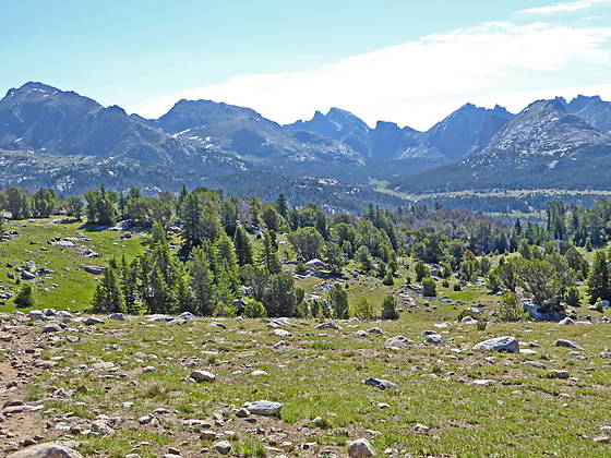
Great view of the peaks ringing the Washakie Valley
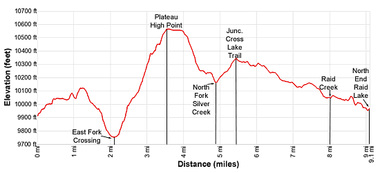
- Distance: 9.1 miles
- Elevation: 9,925-ft. at Junction w/Pyramid Lake Trail
9,755-ft. at East Fork River Crossing
10,565-ft. at High point on the Plateau southwest of Mt. Geikie
10,165 at North Fork Silver Creek
10,347-ft. at Junction with the trail to Cross Lake
10,238-ft. at Sheep Creek
10,047-ft. at Raid Creek
9.970-ft. at Northeast Arm of Raid Lake - Difficulty: moderate-strenuous
- Basecamp: Big Sandy
- Region: Wyoming's Wind River Range
Marms Lake to Raid Lake Description
The junction of the Pyramid Lake trail with the Fremont trail is located a short distance to the north of Marms Lake. Here the Pyramid Lake Trail, signed for Shadow Lake, heads northeast. We bear left (north/northwest) on the continuation of the Fremont Trail, signed for Cross Lake, which climbs a grassy draw on moderate grades. Soon the grade abates as the path travels along the west side of a marsh. Beyond the marsh, a short climb leads to the top of a bench at 0.4 miles.
On the bench the trail skirts the left (west) side of a small pond and then the right (east) side of an unnamed lake before curving right (northeast), traversing the bench where small ponds lie nestled in the meadows amid scattered trees and rock outcroppings. At 0.8 miles the grade steepens briefly as the trail ascends along the east side of a low ridge.
Reach the high point along the ridge at 1.0 mile. Here the trail drops down to cross a draw. On the north side of the draw the grade again steepens as the path climbs a knoll. Atop the knoll views open to Bernard Peak (12,193-ft.), Washakie Pass (11,611-ft.), Mount Washakie (12,524-ft.) and Big Chief Mountain (12,335-ft.) to the northeast.
At 1.3 miles the trail turns left (north) into the Washakie Creek Valley and descends along the east side of the knoll. Ahead are fine views of the cirque formed by Mount Geikie (12,378-ft.), Mount Bonneville (12,585-ft.), Tower Peak (12,330-ft.), Mount Hooker (12,504-ft.) and Pyramid Peak (12,030-ft.), at the head of the East Fork Valley. Washakie Creek wanders through meadows and clusters of willows along the valley floor.
At 1.5 miles the trail turns left (west) and begins a descent down a draw along the south side of a rocky knoll rising between the trail and a long meander on Washakie Creek. Scenic campsites, nestled in grassy bowls amid rock outcroppings, are located along the east side of the knoll.
Soon the trail curves to the right (northwest) and drops down a rocky hillside on moderately steep switchbacks before turning west again and dropping down to the confluence of Washakie Creek and the East Fork River in a large meadow. Here there are two crossings, the first and easiest is a tributary of Washakie Creek. Late in the season you may be able to rock-hop across the stream and keep your feet dry, otherwise wading is required.
After the first crossing the trail traverses boggy meadows and soon reaches the east shore of the East Fork River at 2.1 miles. Here you will definitely need to remove your boots and wade across the knee-deep river with a gentle to moderate currents.
Beyond the crossing reach a trail junction at 2.25 miles. Here the trail to Boulter Lake turns left (south). We continue straight ahead (west) on the Fremont Trail toward Cross Lake. Past the junction the trail climbs on moderate to steep grades through meadows and then trees up the west side of the East Fork Valley. Along the way you will cross a small stream several times.
As you ascend the trail curves to the right (north) and then left (northwest). Small meadows and openings in the trees offer views up the length of the Washakie Creek Valley. Mount Washakie and Big Chief Mountain rim the valley to the north while Easy Day Peak (11,660-ft.) rises to the south. At the head of the valley is the distinctive profile of the backside of the Cirque of the Towers.
The grade eases briefly at 3.1 miles as the trail crosses a small draw and then ascends along a pretty stream adorn with wildflowers. Here the trees give way to meadows and views open to the peaks rising above the East Fork valley to the northeast. Mount Geikie dominates the view to the north.
Soon the trail curves to the left (west) and climbs on moderate grades to a high plateau clad in alpine meadows that stretch from the southwestern flanks of Mount Geikie to Twin Buttes (11,108-ft. and 10,828-ft.) to the south. From the meadows the backside of the Cirque of the Towers and the high peaks towers above the Washakie Creek valley fills the skyline to the east. Twin Buttes rise above the south end of the plateau while Mount Geikie dominates the view to the north.
Reach the high point of the plateau (10,565-ft.) at 3.6 miles. The trail now traverses the plateau heading west/northwest, passing two tarns along the way. Lupines and small wildflowers grow amid the alpine meadows. Large rocks along the trail offer places to rest and take in the views.
Soon the trail begins a gentle descent and we gradually lose the view of the cirque. Ahead distant views open to the peaks rising along the west side of the Continental Divide including Halls Mountain (12,475-ft.), Europe Peak (12,259-ft.), Mount Victor (12,254-ft.) and Mount Lester (12,342-ft.).
The descent steepens at 4.1 miles as the trail drops off the plateau. Soon the grade eases as the path skirts the western shore of an unnamed lake. Beyond the lake’s outlet stream the descent resumes as the trail drops to the North Fork of Silver Creek at 4.9 miles.
Rock-hop across the creek and ascend a hillside skirting the west side of a boggy meadow. Past the meadow the path climbs through rocky meadows scattered with trees to the top of a ridge and a "Y" intersection at 5.5 miles. The trail branching to the left leads to Cross Lake. We bear right toward Raid Lake on the continuation of the Fremont Trail.
Beyond the junction the trail travels through an undulating landscape alternating between meadows and trees, passing to the east of two lakes. The south side of the first lake offers a few nice campsites with terrific views of the peaks rising to the north.
At 6.2 miles the trail reaches the edge of a large meadow. Here the trail descends to Sheep Creek at 6.4 miles. Rock-hop across the creek and then follow the trail as it traverses the meadow. Along the way enjoy great views of Ambush (12,173-ft.) and Raid (12,532-ft.) peaks rising to the east/northeast. Cross Lake (10,086-ft.) lies nestled in a vast meadow to the west.
Soon the trail starts descending on easy grades to the east of Cross Lake, traveling through rocky meadows and scattered trees. After crossing an inlet stream the trail climbs over a low rise and then descends through meadows with fine views of Raid Peak, Mount Bonneville (12,585-ft.) and Pronghorn Peak (12,388-ft.) towering above the east side of the valley.
At 7.7 miles the terrain changes markedly as the trail now travels through a crumpled landscape of meadows growing amid boulders, rock outcroppings and scattered trees to the east of Raid Lake. You will know you are on the trail to the east of the lake when you cross Raid Creek at 8.0 miles although you will not see the lake until you reach its northern end. Here a sign marks the crossing and points south to Cross Lake and north to Raid Lake (actually the head of Raid Lake).
This section of the trail is somewhat tedious, with many ups and downs as the path weaves its way around boulders and rock outcroppings, passing small ponds and crossing an occasional creek. Near the head of the lake the trail climbs over two low hills. Here views open to the peaks towering above Bonneville Lakes to the east. Soon the northeast arm of Raid Lake comes into view.
After climbing over the second hill the trail drops down to and curves to the left (northwest) around the top of the arm, crossing the wide inlet stream, the South Fork of Boulder Creek, at 9.1 miles. Rock-hop across the stream, which is typically not very deep.
A short distance beyond the crossing, reach an unmarked junction where the use trail to Bonneville Lakes basin branches right (northeast). The Fremont Trail continues straight ahead and then curves to the west, skirting the north shore of a small pond.
The trees on the hillside to the north of the lake harbor some nice campsites. Exposed sites are located along the northeast shore. For even better sites, ascend the Bonneville Lakes trail for a half mile to a large tree fringed meadows with great views of Raid Peak, Mount Bonneville, the Twin Lions and Pronghorn Peak.
Return to Segment 1: Big Sandy to Marms Lake
Go To Segment 3: Raid Lake to Middle Fork Junction above Sandpoint Lake
Elevation Profile
Backpack Segments
- Introduction: Big Sandy to Elkhart Park via Fremont and Highline Trails
- Segment 1: Big Sandy to Marms Lake
- Segment 2: Marms Lake to Raid Lake
- --- Side Trip: Bonneville Lakes
- Segment 3: Raid Lake to Middle Fork Junction above Sandpoint Lake
- --- Side Trip: Middle Fork Lake Trail
- --- Side Trip: Middle Fork Lake via the Rainbow Lake Trail
- --- Side Trip: Photo Pass Trail
- Segment 4: Sandpoint Lake to Valley Lake Junction
- --- Side Trip: Europe Canyon and Pass
- Segment 5: Valley Lake Junction to North Fork Lake
- --- Side Trip: Hay Pass, the Golden Lakes and Fall Creek Pass
- Segment 6: North Fork Lake to Bell Lakes Junction
- Segment 7: Bell Lakes Junction to Pole Creek
- --- Side Trip: Cook and Wall Lakes
- Segment 8: Pole Creek to Little Seneca Lake
- Segment 9: Little Seneca Lake to Island Lake
- --- Side Trip: Titcomb Basin
- --- Side Trip: Indian Basin and Pass
- --- Side Trip: Island Lake Waterfall Hike
- Segment 10: Island Lake to Elkhart Park
Driving Directions to Big Sandy Trailhead
Big Sandy Trailhead: This popular trailhead is located in the southern Wind River Range next to the Big Sandy River.
Directions from Pinedale: From the intersection of Pine Street (US 191) and North Tyler Ave (the Pinedale Tourism office is located on the northeast corner) in Pinedale, WY, drive south on Highway 191 for 11.7 miles and then turn left (east) on WY-353. After 15.5 miles you will notice signs referring to the road as the Big Sandy-Elkhorn Road and after 18 miles the paved road will change to a good packed dirt/gravel surface.
Shortly after the pavement ends go straight through a junction, and drive south crossing the Big Sandy River (Buckskin Crossing). Follow the road for a total of 27.3 miles. Shortly after crossing the Big Sandy River you will reach a junction with the Lander Cutoff Road (the next junction). Turn left on the Lander Cutoff Road. There is a wood sign at the intersection pointing toward the Big Sandy trailhead.
Drive 7.0 miles on the Lander Cutoff Road and then turn left on the Big Sandy Opening Road. Here you will see a sign for the Big Sandy Campground and trailhead. The road now deteriorates and narrows. Blind corners and lush foliage along the road make it hard to see ahead. Drive carefully, following the rocky, rutted road for 9.8 miles to a "Y" intersection. Bear right at the intersection to continue along the Big Sandy Opening Road (Forest Service Road 850). (The road branching to the left leads to the Big Sandy Lodge and Mud Lake.) Follow the road for 0.8 miles to the trailhead parking area, equipped with an outhouse.
Allow an hour and a half to reach the trailhead from Pinedale. The parking area is too small for the number of backpackers visiting the area during the height of the summer. If the parking area is full, find a safe place to park off the access road.
I recommend a high clearance vehicle to reach the trailhead. Passenger cars can make it OK if driven carefully. Check at the Pinedale ranger station before starting your trip to learn about current road and trail conditions. The Ranger Station is located to the east of the Ridleys Grocery Store on US 191 (Pine Street in Pinedale). The entrance to the ranger station is on the Fremont Lake Road. (You can also reach the parking area for the ranger station by driving east through the Ridley’s parking lot.)
This trailhead is remote, so be sure to have a full tank of gas. The dirt road become slippery when wet. The campground at the parking area is tiny, with only 4 sites. I would not plan on camping at the trailhead before starting your backpack.
Elkhart Park Trailhead: From the intersection of Pine Street (US 191) and North Tyler Ave (the Pinedale Tourism office is located on the northeast corner) in Pinedale, WY, drive east on Highway 191 (East Pine Street) for 0.3 miles and bear left onto Fremont Lake Road. Follow this road for 14.3 miles and turn right into the large parking area for the Elkhart Park/Pole Creek Trailhead. After the first 3.0 miles the road will turn into Skyline Drive/Forest Service Road 370740. The trailhead is located at the northeast end of the parking lot between the outhouse and the trailhead kiosk. It should take about 25 minutes to drive the trailhead. The last section of the road has some holes and uneven spots.
Trail Resources
- Backpack Intro
- Segment Photo Gallery
- Segment Map
- Trailhead(s) Information: Big Sandy
- Region Information: Wyoming's Wind River Range
- Other Hiking Regions in: Wyoming