Backpack: Big Sandy to Elkhart Park via Fremont and Highline Trails
Side Trip: Titcomb Basin
Distance: 9.9 miles (round trip)
Bridger Wilderness, Bridger-Teton National Forest, near Big Sandy in Wyoming's Wind River Range
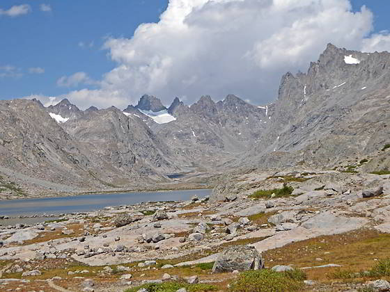
Cirque at the head of Titcomb Basin
- Distance: 9.9 miles
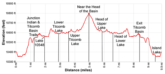
- Elevation: 10,410-ft. at Island Lake
10,545-ft. at junction Indian and Titcomb Basin trails
10,548-ft. at Lake 10548
10,575-ft. at Lower Titcomb Lake
10,598-ft. at Upper Titcomb Lake
10,790-ft. near the Head of the Basin - Difficulty: moderate
- Basecamp: Big Sandy
- Region: Wyoming's Wind River Range
Titcomb Basin Description
This hike starts from at the unmarked junction at the southeast end of Island Lake (10,346-ft.). The trail to the left (northwest) leads to campsites along the lake’s southwestern shore. The trail straight ahead (northeast) is the Indian Pass trail.
Follow the Indian Pass trail as it skirts the eastern shore of Island Lake. Along the way enjoy fine views of the summits towering above Titcomb Basin to the north. Elbow (11,948-ft.) and Sky Pilot (12,129-ft.) peaks rise in the distance to the northwest.
Pass an unmarked trail/route at 0.3 miles climbing to Pass 11120, a saddle on the ridge between the Island and Wall Lake basins. Soon our trail curves to the left (northwest) around the northeast lake shore and starts climbing.
At 0.7 miles the path curves to the right north and ascends the north side of a draw to a saddle on a low ridge at 0.9 miles. Atop the ridge are more great views of the summits of Titcomb Basin.
The trail now descends through meadows into a pretty basin cradling Lake 10,467. Pass above the lake’s eastern shore and then climb around a minor ridge at the northeast end of the lake, paralleling the lake’s inlet stream (the creek draining Indian Basin).
Reach the junction of the Indian Pass and Titcomb Basin trails at 1.2 miles. Here the trail to Indian Pass turns right (northeast). We continue straight ahead (north) on the Titcomb Basin Trail.
A short distance past the junction the trail crosses the stream draining Indian Basin by hopping across the large boulders that litter the creek bed. Beyond the crossing the trail traverses meadows and passes a small pond. The path now weaves through rock outcroppings as it ascends a hill to a gap strewn with large boulders. Squeeze through the gap and then climb over a low hump, emerging onto the rocky meadows at the foot of Titcomb Basin at 1.6 miles.
The long, stunningly beautiful basin is rimmed with 12,000- and 13,000-ft. peaks culminating in a cirque of jagged summits that include Mount Woodrow Wilson (13,502-ft.), the Sphinx (13,258-ft.), Twin Peaks (13,185-ft.), Bob’s Tower (13,040-ft.) and Miriam Peak (13,480-ft.). Snowcapped Gannett Peak (13,804-ft.), the highest point in Wyoming, is seen in the gap between Mt. Woodrow Wilson and the Sphinx. As you ascend the basin enjoy ever improving views of the cirque along with the peaks lining the basin’s eastern and western walls.
Travel is now easy as the trail skirts the eastern shore of Lake 10,548, reaching the northern end of the lake at 2.2 miles. Here the trail climbs a rocky knoll on moderate grades and then descends into the next lake basin. Ahead, views open to Lower Titcomb Lake (10,575-ft.) sprawled across the valley floor.
The path now traverses through meadows strewn with boulders along the lake’s eastern shore. To the west views open to Titcomb Needles. The rugged west facing slopes of Fremont Peak (13,745-ft.) loom over the trail to the east.
Reach the head of the lower lake at 3.3 miles. Cross the isthmus separating the upper and lower lakes, briefly traveling along the east side of the outlet stream for the upper lake before arriving at the southeastern shore of Upper Titcomb Lake (10,598-ft.) at 3.6 miles.
The trail now travels through rocky meadows and small talus fields along the east shore of the upper lake. Across the lake a waterfall, emanating from Summer Ice Lake (11,170-ft.), cascades down a rocky gully along Titcomb Basin’s western wall. The unseen lake lies in a small cirque formed by The Great Needle (12,714-ft.), Henderson Peak (13,115-ft.), American Legion Peak (13,205-ft.), Winifred Peak (12,775-ft.) and the Buttress (12,205-ft.). Along the east side of the basin Mount Sacagawea (13,569-ft.) towers overhead while the distinctive towers and spires of Mount Helen (13,620-ft.) dominate the east wall beyond the lake.
Pass the north end of the upper lake at 4.3 miles. Here the trail starts climbing on easy to moderate grades through meadows and then across large rock slabs. Rock cairns mark the trail across the slabs. The trail gets harder to follow as you near the head of the basin.
The open country invites exploration and is a photographer’s delight. Wander as far up valley as time and energy permit and then find a good perch to take in the views. When you are done absorbing the amazing scenery retrace your steps.
Backpacker looking to camp in Titcomb Basin will find the best sites to the south of Lower Titcomb Lake. Climbers typically setup camp in the upper basin, beyond the lakes. Finding a level campsite that is at least 200-ft. from trails and water is somewhat of a challenging. Hanging food is also problematic due to the lack of trees. You will need to find a large boulder to hang your food or carry a bear container.
Return to Segment 9: Little Seneca Lake to Island Lake
Go To Segment 10: Island Lake to Elkhart Park
Elevation Profile
Backpack Segments
- Introduction: Big Sandy to Elkhart Park via Fremont and Highline Trails
- Segment 1: Big Sandy to Marms Lake
- Segment 2: Marms Lake to Raid Lake
- --- Side Trip: Bonneville Lakes
- Segment 3: Raid Lake to Middle Fork Junction above Sandpoint Lake
- --- Side Trip: Middle Fork Lake Trail
- --- Side Trip: Middle Fork Lake via the Rainbow Lake Trail
- --- Side Trip: Photo Pass Trail
- Segment 4: Sandpoint Lake to Valley Lake Junction
- --- Side Trip: Europe Canyon and Pass
- Segment 5: Valley Lake Junction to North Fork Lake
- --- Side Trip: Hay Pass, the Golden Lakes and Fall Creek Pass
- Segment 6: North Fork Lake to Bell Lakes Junction
- Segment 7: Bell Lakes Junction to Pole Creek
- --- Side Trip: Cook and Wall Lakes
- Segment 8: Pole Creek to Little Seneca Lake
- Segment 9: Little Seneca Lake to Island Lake
- --- Side Trip: Titcomb Basin
- --- Side Trip: Indian Basin and Pass
- --- Side Trip: Island Lake Waterfall Hike
- Segment 10: Island Lake to Elkhart Park
Driving Directions to Elkhart Park Trailhead
Big Sandy Trailhead: This popular trailhead is located in the southern Wind River Range next to the Big Sandy River.
Directions from Pinedale: From the intersection of Pine Street (US 191) and North Tyler Ave (the Pinedale Tourism office is located on the northeast corner) in Pinedale, WY, drive south on Highway 191 for 11.7 miles and then turn left (east) on WY-353. After 15.5 miles you will notice signs referring to the road as the Big Sandy-Elkhorn Road and after 18 miles the paved road will change to a good packed dirt/gravel surface.
Shortly after the pavement ends go straight through a junction, and drive south crossing the Big Sandy River (Buckskin Crossing). Follow the road for a total of 27.3 miles. Shortly after crossing the Big Sandy River you will reach a junction with the Lander Cutoff Road (the next junction). Turn left on the Lander Cutoff Road. There is a wood sign at the intersection pointing toward the Big Sandy trailhead.
Drive 7.0 miles on the Lander Cutoff Road and then turn left on the Big Sandy Opening Road. Here you will see a sign for the Big Sandy Campground and trailhead. The road now deteriorates and narrows. Blind corners and lush foliage along the road make it hard to see ahead. Drive carefully, following the rocky, rutted road for 9.8 miles to a "Y" intersection. Bear right at the intersection to continue along the Big Sandy Opening Road (Forest Service Road 850). (The road branching to the left leads to the Big Sandy Lodge and Mud Lake.) Follow the road for 0.8 miles to the trailhead parking area, equipped with an outhouse.
Allow an hour and a half to reach the trailhead from Pinedale. The parking area is too small for the number of backpackers visiting the area during the height of the summer. If the parking area is full, find a safe place to park off the access road.
I recommend a high clearance vehicle to reach the trailhead. Passenger cars can make it OK if driven carefully. Check at the Pinedale ranger station before starting your trip to learn about current road and trail conditions. The Ranger Station is located to the east of the Ridleys Grocery Store on US 191 (Pine Street in Pinedale). The entrance to the ranger station is on the Fremont Lake Road. (You can also reach the parking area for the ranger station by driving east through the Ridley’s parking lot.)
This trailhead is remote, so be sure to have a full tank of gas. The dirt road become slippery when wet. The campground at the parking area is tiny, with only 4 sites. I would not plan on camping at the trailhead before starting your backpack.
Elkhart Park Trailhead: From the intersection of Pine Street (US 191) and North Tyler Ave (the Pinedale Tourism office is located on the northeast corner) in Pinedale, WY, drive east on Highway 191 (East Pine Street) for 0.3 miles and bear left onto Fremont Lake Road. Follow this road for 14.3 miles and turn right into the large parking area for the Elkhart Park/Pole Creek Trailhead. After the first 3.0 miles the road will turn into Skyline Drive/Forest Service Road 370740. The trailhead is located at the northeast end of the parking lot between the outhouse and the trailhead kiosk. It should take about 25 minutes to drive the trailhead. The last section of the road has some holes and uneven spots.
Trail Resources
- Backpack Intro
- Segment Photo Gallery
- Segment Map
- Trailhead(s) Information: Big Sandy
- Region Information: Wyoming's Wind River Range
- Other Hiking Regions in: Wyoming