Details: North Fork Lake Creek 
Distance: 8.1 miles (round trip)
Mt. Massive Wilderness, San Isabel National Forest, near Buena Vista in Central Colorado
By: Diane Greer
Hike Facts
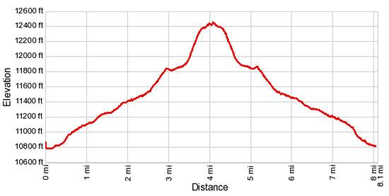
- Distance: 8.1 miles (round trip)
- Elevation: 10,790-ft. - 12,460-ft.
- Elevation Gain: 1,670-ft.
- Difficulty: moderate-strenuous
- Trail Highlights: See Trail Intro
- Basecamp(s): Buena Vista / Aspen
- Region: Central Colorado
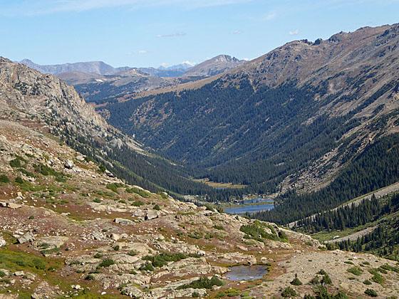
This trail travels up a beautiful, secluded valley to wind swept tarn and then a saddle on the Continental Divide overlooking the Fryingpan Lakes. The quiet valley offers good opportunities to spot wildlife and features fine views of the surrounding high peaks.
North Fork Lake Creek to the Saddle
The North Fork Lake Creek trail initially follows an old jeep road heading north and ascending the west side of the valley floor on easy to moderate grades through meadows scattered with willows and trees. Mt. Champion (13,646-ft.) soars above the valley to the northeast.
At 0.4 miles the grade steepens as the trail climbs to the top of a small bench where the road turns into a trail. Beyond the bench the trail climbs steeply for a short distance and then reverts to more moderate grades at 0.6 miles. Here views open to the peaks towering above the head of the valley.
Reach the boundary of the Mt. Massive Wilderness area at 0.7 miles. The border coincides with a self-permitting station. The Forest Service asks everyone hiking the trail to fill out a free permit.
Beyond the permit station the trail crosses the outlet stream for Blue Lake and then passes a route branching left (northwest) to Blue Lake. The lake, which is not well known, is reported to have great fishing. (More information on Blue Lake route is found at the end of this trail description.)
Our trail continues ascending along the west side of the valley on easy grades, skirting the edge of the timbered slopes. Willow thickets choke the valley floor along the creek.
At 1.4 miles the trees give way to meadows and clusters of willows. Views toward the head of the valley expand to include Peak 13202 to the northwest. Turn around for good views of Lackawanna Peak (13,823-ft.) rising above the southeast end of the valley.
Reach the edge of the western tributary of the North Fork Lake Creek and a confusing section of the trail at 2.3 miles. A good trail appears to continue along the left (west) side of the creek. Look across the creek to see the continuation of the trail on the other side. Late in the season you should be able to rock-hop across the creek without getting your feet wet. Earlier in the season you may need to wade the stream.
Note: If you miss the crossing, the trail/route along the left (west) side of the stream weaves through thick willow thickets and, at times, becomes quite faint. After 0.2 miles the route comes to a second crossing that is easier when the water is high. If you take this route look across the stream and up the hill, at approximately one o-clock you will see a rock cairn. Climb up the hill to the cairn to get back on the main trail.
Beyond the crossing the grade steepens as the trails climbs toward the head of the valley, defined by two large basins to the west and the east. As you ascend views open the stunning basin surrounded by high peaks to the west. Deer Mountain towers above the basin to the east.
At 2.8 miles the trail curves to the right (northeast) and crosses a ridge through a stand of trees. Beyond the ridge the trail descends slightly before continuing its ascent on easy grades through meadows to the scenic basin beneath Deer Mountain. Turn around for great views of the basin to the west along with Twining Peak (13,711-ft.) and the unnamed summits lining the western side of the North Fork Lake Creek valley. Star Mountain (12,941-ft.) and summits in the Collegiate Peak Wilderness are visible to the south.
Reach the eastern tributary of North Fork Lake Creek at 3.2 mile. Here the creek braids into multiple channels. There are two trails through this area. The best option is to follow the trail that stays to the left (north) of the creek for 0.1 mile. Watch for rock cairns in the meadows to the right (south) marking where you should cross the main channel and rejoin the trail heading up the center of the basin. The other option is to immediately cross the main channel and then follow a faint trail up the center of the basin through boggy meadows. The two trails converge at 3.3 miles.
Toward the head of the basin the trail curves to the left (northeast) and climbs steep switchbacks up a hillside to the west of Deer Mountain, staying to the right (east) of a creek tumbling down the hill. Near the top of the climb the trail crosses the creek.
The trail crests the hill at 3.8 miles, reaching a high bench clad in alpine tundra where a cobalt blue lake (12,400-ft.) lies nestled beneath the northwest ridge of Deer Mountain. Our objective, the saddle to the north of the lake, is now in sight.
Follow the trail as it curves around the west side of the wind-swept lake and then climbs through rocky meadows to the pass at 12,460-ft. From the pass fine views extend north down the Fryingpan Lakes valley to the Fryingpan Lakes. The high peaks of the Hunter-Fryingpan and Holy Cross Wilderness areas rise beyond the valley. To the south an unnamed 13,736-ft. peak rises above a small basin. The summits of the Collegiate Peaks Wilderness fill the skyline to the southeast.
When you are done enjoying the views retrace your steps to the trailhead. The descent down the Deer Mountain basin features excellent views of the beautiful west basin, Twining Peak (13,711-ft.) and the summit rimming the west side of the valley.
Blue Lake Trail
The Blue Lake trail, branching left (northwest) from the North Fork Lake Creek trail, climbs on very steep grades through trees along the right (north) side of Blue Lake's outlet stream. At 0.5 miles the trees give way to pretty alpine meadows and the grade eases a bit. Continue along the trail as it continues ascending on steep to moderately-steep grades through meadows.
The trail becomes difficult to follow as it travels through boggy areas and soon disappears. Rock cairns now mark several routes to the lake. The best route will vary depending on the time of year. The route closest to the stream is the shortest but is quite boggy early in the season.
Reach Blue Lake (12,495-ft.), nestled beneath Twining Peak (13,711-ft.), after gaining over 1,400 feet in 1.5 miles. Total distance from the North Fork Lake Creek trailhead to Blue Lake is 2.2 miles one-way.
Elevation Profile
Buy the BookThis opinionated guide includes all the hikes in the Aspen, Buena Vista, Crested Butte, Marble and Leadville sections of the website plus info on local services and nearby attractions. | |
Driving Directions
From Buena Vista: From the traffic light at the intersection of U.S.24 and Country Road 306 in downtown Buena Vista, head north on US 24 W for 19.2 miles and turn left (west) on CO 82 W. Follow CO 82 for 19.1 miles and then turn right at the North Fork Lake Creek trailhead. The turn is just past mile marker 66 and before the first hairpin curve on the switchbacks climbing to Independence Pass. Follow the dirt road for 0.1 miles to the parking area. A trailhead bulletin board marks the start of the trail.
From Leadville: From the intersection at 6th Street and Harrison (U.S.24), head east on US 24 E for 15 miles and turn right (west) on CO 82 W. Follow CO 82 for 19.1 miles and then turn right at the North Fork Lake Creek trailhead. The turn is just past mile marker 66 and before the first hairpin curve on the switchbacks climbing to Independence Pass. Follow the dirt road for 0.1 miles to the parking area. A trailhead bulletin board marks the start of the trail.
From Aspen: From the intersection of Main Street and South Galena in downtown Aspen, drive east on CO 82 E for 24.2 miles and turn left at the North Fork Lake Creek trailhead. The turn is 4.5 miles down the east side of Independence Pass, just past the third hairpin curve on the road. Follow the dirt road for 0.1 miles to the parking area. A trailhead bulletin board marks the start of the trail.
Trail Resources
Trail Intro / Trail Photo Gallery / Trail Map
Basecamp(s) Information:
Buena Vista / Aspen
Region Information:
Central Colorado
Other Hiking Regions in:
Colorado