Details: Bear Creek Falls 
Distance: 4.6 miles (round trip)
Uncompahgre National Forest, near Telluride in Southwest Colorado
By: Diane Greer
Hike Facts
- Distance: 4.6 miles (round trip)
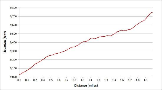
- Elevation: 8,800-ft. - 9,940-ft.
- Elevation Gain: 1,140-ft.
- Difficulty: easy-moderate
- Trail Highlights: See Trail Intro
- Basecamp(s): Telluride
- Region: Southwest Colorado
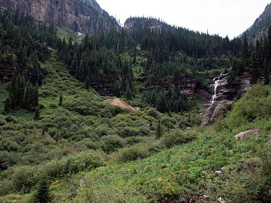
This half day hike up Bear Creek Canyon offers scenic views of the rugged cliffs lining the canyon and ends at a pretty waterfall. It’s a nice option if you have limited time or just want an easy day.
Trailhead to Bear Creek Falls
The Bear Creek trail starts on the end of South Pine Street (see driving directions) on a wide dirt track shared with bikers and horseback riders. Follow the trail as it heads up hill to a sign marking the beginning of the Bear Creek Preserve. The San Miguel Conservation Foundation, in partnership with the town of Telluride, acquired and donated a 320-acre parcel of land in the Bear Creek Canyon to the citizens of Telluride in 1995 to preserve Bear Creek as public open space.
Beyond the sign the trail heads southeast toward Bear Creek Canyon, climbing through a forest of aspen and mixed conifers. Openings in the trees offer nice views to the north of the cliffs and peaks towering above Telluride.
At 0.6 miles the trail swings to the south and enters the canyon, continuing its ascent along the west side of Bear Creek, which can’t be seen from the trail. After hiking about 1.2 miles the trees start to thin and meadows appear along the trail. The openings offer great views of the dramatic cliffs defining the canyon’s eastern wall.
The scenery continues to improve as you climb. At just under 1.7 miles the creek comes into view at a pretty spot with a small waterfall. Rock cairns of all shapes and sizes decorate the meadow by the creek.
Reach a junction with the Wasatch trail in a large open meadow at 2.0 miles. Beautiful Bear Creek Falls is seen through the trees cascading down a rocky cliff at the head of a small basin. Continue straight ahead on the trail for 0.3 miles, following the path as it wandering beside the creek through meadows to the base of the falls. (The Wasatch trail branches to the right (west) and climbs the hillside above the trail.)
After exploring the falls, retrace your steps to the trailhead, enjoying nice views of the peaks and ridges rising to the north of Telluride.
Hikers with the time and energy will want to explore further up the canyon on the Wasatch Trail. The Bear Creek trail is also used as part of a loop that connects with the See Forever trail. (See the Wasatch and See Forever descriptions for more information.)
Elevation Profile
| Buy the BookThis opinionated guide includes all the hikes in the Ouray, Telluride, Silverton and Lake City sections of the website plus info on local services and nearby attractions. |

Driving Directions
From Telluride: From Telluride: From Telluride's main street (Colorado Avenue), turn south onto Pine Street and walk 4 blocks. After crossing the river the street turns into a dirt road that becomes the Bear Creek Trail.
Note: Parking in Telluride can be difficult. Parking is by permit only on many of the streets in the residential section of town and is limited to two-hour parking along Colorado Avenue and its adjacent side streets. Free day-use parking is available in the Carhenge Lot, just off West Pacific Avenue at the west end of town near the base of Lift 7, or at the south end of Mahoney Drive near the west entrance to town. A free shuttle bus, called the Galloping Goose, runs between the parking lots and various stops in downtown Telluride.
There is also free parking in the mountain village. From there you can take the free gondola to town and walk to the trailhead.
Trail Resources
Trail Intro / Trail Photo Gallery / Trail Map
Basecamp(s) Information:
Telluride
Region Information:
Southwest Colorado
Other Hiking Regions in:
Colorado