Details: Wasatch Trail 
Distance: 12.3 miles (round trip)
Uncompahgre National Forest, near Telluride in Southwest Colorado
By: Diane Greer
Hike Facts
- Distance: 12.3 miles (round trip)
- Elevation: 8,800-ft. - 13,050-ft.
- Elevation Gain: 4,250-ft.
- Difficulty: strenuous
- Trail Highlights: See Trail Intro
- Basecamp(s): Telluride
- Region: Southwest Colorado
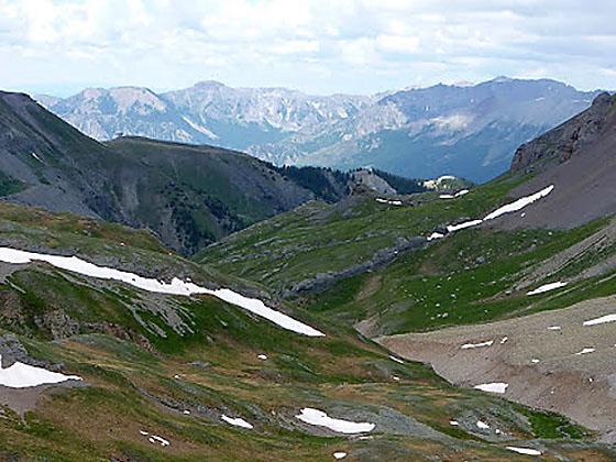
Dramatic views of Bear Creek Canyon, beautiful alpine basins, wildflowers and waterfalls are a few of the delights on this steep trail to visit the saddle (13,050-ft.) on the divide between Bear Creek and Bridal Veil basins. The hike includes an initial 2.0-mile segment of the popular Bear Creek Falls trail.
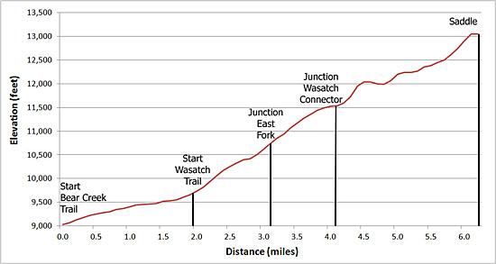
Bear Creek Trailhead to the junction with the Wasatch Connector
Distance from Trailhead: 8.2 miles (round trip)
Ending/Highest Elevation: 11,530-ft.
Elevation Gain: 2,730-ft.
Follow the Bear Creek trail, a wide dirt track shared with bikers and horseback riders, as it climbs at a steady pace through a forest of aspen and mixed conifers. As you ascend the trees thin and intermittent meadows provide fine views of the dramatic cliffs defining the canyon’s eastern wall.
Reach the junction with the Wasatch trail after walking 2.0-miles and gaining 1,380-ft. Turn right (west) at the junction on the Wasatch Trail and follow the narrow path as it climbs steep switchbacks through groves of aspen and evergreens, gaining 575-ft. in over 0.5 miles. At the top of the switchbacks the grade abates and the trail traverses high above the canyon floor for about a mile, eventually meeting Bear Creek at the base of a gully.
Ascend the gully on a steep track. Bear Creek cascades over rocks and wood debris in the stream bed next to the trail. Near the top of the gully pass the remnants of the Nellie mine on the right (west) side of the trail.
Beyond the mine cross a debris pile caused by a rock slide and come to junction with the East Fork Bear Creek trail. The East Fork Bear Creek trail, going left at the junction, climbs the eastern side of the East Fork of Bear Creek for 0.9 miles to meet the Wasatch trail in the upper East Fork basin. This section is much shorter but also considerably steeper than the alternative route up the Wasatch trail. Some hikers make a loop out of the Wasatch and East Fork or simply use it as an alternate means of descending from the Wasatch Basin on the return hike.
My advice is to go right at the trail junction and stay on the Wasatch. To circumvent the basin’s rocky headwall, the trail climbs a series of steep switchbacks, gaining 500-ft. in 0.5 miles, and then traverses the canyon’s western wall on a gentle grade to meet Bear Creek at the top of the headwall. A short distance from the top of the headwall the Wasatch meets the Wasatch Connector trail descending from the ski area to the west (right).
Wasatch Connector Junction to the Saddle
Distance from Trailhead: 12.3 miles (round trip)
Ending/Highest Elevation: 13,050-ft.
Elevation Gain: 4,250-ft.
At the signed junction turn left (east) and follow the Wasatch Trail as it crossed Bear Creek and then climbs steeply through meadows to a shelf atop a rocky knoll. As you climb enjoy the fine views extending north/northwest across the Telluride Valley and west to the Gold Hill ski area.
At the top of the knoll the trail drops gently to and crosses the East Fork of Bear Creek, arriving at a junction where the East Fork of Bear Creek Trail rejoins the Wasatch Trail. Go right (east) at the junction, continuing on the Wasatch Trail as it ascends 600-ft. over a mile through wildflower-filled meadows toward the base of the saddle at the head of the cirque anchored by the San Joaquin Ridge to the south and Wasatch Mountain (13,555-ft.) to the north.
The final ascent to the saddle is quite steep, climbing almost 500-ft in just under 0.5 miles. From the saddle views extend west toward the San Joaquin Ridge and Silver Mountain. To the east are the peaks and ridge rising above upper Bridal Veil Basin.
Once you are done soaking in the scenery, turn around and retrace your steps. For variety you can take the East Fork trail on the return leg, but be forewarned that it is quite steep.
With planning it is possible to extend the hike into a long loop by crossing the saddle and returning via Bridal Veil Basin. Walking the entire loop, including the road down from the Bridal Veil Power Plant to the Pandora Mine and back to downtown Telluride, is close to 14.3 miles. The better option is to get dropped at the Bridal Veil Power plant and do the hike in reverse, up Bridal Veil basin and down the Wasatch. This reduces the elevation gain to 2,650-ft from 4,250-ft. and cuts 4.0-miles off the trip.
To do the loop, descend the east side of the saddle to a unmarked junction. Turn left (northeast) and descend through Bridal Veil Basin. (The trail to the right climbs to saddle and ends up in Ophir.) At the first intersection, marked by a post, head left (northeast). The trail to the right climbs to Lewis Lake and Mine.
Follow the trail, which starts as a double track and then becomes a gravel road, down the basin to the Bridal Veil Power Plant, where hopefully a car awaits to take you back to Telluride. If not, walk down the Bridal Veil 4WD road to the Pandora Mine and then follow the Idarado Legacy Trail to the San Miguel River Trail back to town. Note the walk from the power plant to town is 4.0-miles.
See the Lewis Lake and Mine trail description for more information on hiking Bridal Veil basin.
Elevation Profile
| Buy the BookThis opinionated guide includes all the hikes in the Ouray, Telluride, Silverton and Lake City sections of the website plus info on local services and nearby attractions. |

Driving Directions
From Telluride: From Telluride: From Telluride's main street (Colorado Avenue), turn south onto Pine Street and walk 4 blocks. After crossing the river the street turns into a dirt road that becomes the Bear Creek Trail. Proceed south on the trail for 2.0 miles to the Wasatch Trail.
Note: Parking in Telluride can be difficult. Parking is by permit only on many of the streets in the residential section of town and is limited to two-hour parking along Colorado Avenue and its adjacent side streets. Free day-use parking is available in Carhenge Lot, just off West Pacific Avenue at the west end of town near the base of Lift 7, or at the south end of Mahoney Drive near the west entrance to town. A free shuttle bus, called the Galloping Goose, runs between the parking lots and various stops in downtown Telluride.
Trail Resources
Trail Intro / Trail Photo Gallery / Trail Map
Basecamp(s) Information:
Telluride
Region Information:
Southwest Colorado
Other Hiking Regions in:
Colorado