Details: Siyeh Bend to Sunrift Gorge 
Distance: 10.1 miles (one way)
Glacier National Park, near St Mary in Glacier Natl Park, MT
By: Diane Greer
Hike Facts
- Distance: 10.1 miles (one way)
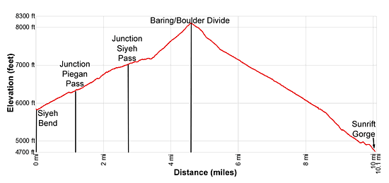
- Elevation: 5,840-ft. - 8,110-ft.
- Elevation Gain: 2,270-ft.
- Difficulty: strenuous
- Trail Highlights: See Trail Intro
- Basecamp(s): St Mary / West Glacier
- Region: Glacier Natl Park, MT
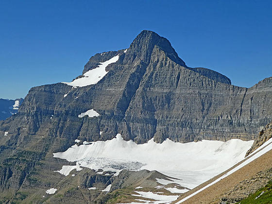
Stunning views of Preston Park, the Baring-Boulder Divide and the Baring Creek Valley are the highlights of this great hike circumnavigating the Going-to-the-Sun Mountain and Matahpi Peak massif. The hike uses the Glacier shuttle bus to complete the loop.
Trailhead to the Divide
Distance from Trailhead: 4.6 miles (one way)
Ending/Highest Elevation: 8,110-ft.
Elevation Gain: 2,270-ft.
The trailhead for Siyeh and Piegan Pass trails is located on the north side of the Siyeh Bend curve just east of where Siyeh Creek flows under the road. A brown sign, labeled Piegan Pass, marks the spot. You are actually starting on what is known as the Siyeh Bend Cut-off trail that climbs to meet the Piegan Pass trail.
From the road the Siyeh Bend Cut-off trail drops down to and travels along the right (east) side of Siyeh Creek. Straight ahead Cataract Mountain (8,180-ft.) and Mount Siyeh (10,014-ft.) rise above the head of the valley. To the left (west) Piegan Mountain (9,220-ft.) looms above the trail.
At 0.1 miles the trail turns right, curving to the southeast as it begins a moderately steep traverse through stunted pines and then thick spruce-fir forest, rock-hopping across a series of small creeks along the way. Two logs span a wide creek crossing at 1.0 mile. Rock hop across the next creek, located a short distance beyond.
Reach the junction with the Piegan Pass trail at 1.1 miles. The Piegan Pass trail to the right (south) drops downs to the Going-to-the-Sun Road. Bear left on the Piegan Pass trail toward Piegan Pass and the Siyeh Pass trail junction. The ascent continues as the trail curves to the north, crossing two more streams. Two logs facilitate the first crossing during high water. Otherwise both creeks are easily crossed on rocks without getting your feet wet.
At 1.4 miles the trail traverses a small meadow sprinkled with wildflowers. The open area provides your first views of the Going-to-the-Sun Mountain (9,642-ft.) rising above the trees to the right (east/southeast). Soon the thick forest gives way to intermittent meadows with partially obscured views of Piegan Mountain across the valley.
The lower slopes of Matahpi Peak (9,365-ft.), to the east, form the backdrop for a pretty creek spanned by a wooden bridge at 2.3 miles. Beyond the crossing the grade abates as the trail passes through stands of stunted trees and pretty meadows with fine views of Mt Siyeh (10,014-ft.) rising to the north, Piegan Mountain (9,220-ft.) to the west and Pollack Mountain (9,190-ft.) to the northwest.
Turn right (east) at 2.6 miles on the Siyeh Pass trail. The trail to the left (northwest) heads to Piegan Pass.
The Siyeh Pass trail ascends beautiful Preston Park on easy grades, passing through stands of subalpine larch, dwarf firs and stunted pines interspersed with lovely meadows dotted with wildflowers. The meadows afford great views of Mt. Siyeh rising above the north side of the valley and Matahpi Peak to the south. Behind you, to the west, Piegan Mountain fills the skyline. Soon views open to Siyeh Pass, the saddle on the ridge at the east end of the valley.
At 2.9 miles the trail passes to the north of a tarn and then makes a brief jog to the north before resuming its easterly course. Reach a wide, rushing stream at 3.3 miles. Wade or rock hop across the stream which drains a small lake cradled beneath the southern flanks of Mt. Siyeh.
Past the stream crossing the trail starts a steep climb up the northern slopes of Matahpi Peak toward Siyeh Pass, traversing meadows and talus slopes along the way. A few switchbacks facilitate the ascent. As you climb, enjoy ever improving views of Mt. Siyeh rising above the north side of the valley. To the west, Reynolds (9,125-ft.), Piegan and Pollack Mountains form a stunning backdrop for Preston Park’s gorgeous meadows and krummholz.
At 4.2 miles the trail travels above and to the south of Siyeh Pass (7,750-ft.), the grassy saddle on the ridge between Mt. Siyeh and Matahpi Peak. Continue following the trail as it ascends switchbacks up steep talus slopes toward the Baring/Boulder Creek Divide. As you climb, views open to the Boulder Creek Valley to the east of Siyeh Pass.
Reach the Divide (8,110-ft.), marked by a large rock cairn, at 4.6 miles. A knife-edge ridge rises above the divide to the east. The Boulder Creek Valley extends northeast below the Divide. Matahpi Peak soars overhead.
For the best views continue over the divide for a short distance. Soon views open to Sexton Glacier cradled in a bowl along the southeastern flanks of Matahpi Peak. Going-to-the-Sun rises to the south of Matahpi Peak. From this vantage point vistas extend south down the Baring Creek Valley to the west end of St. Mary Lake. Little Chief Mountain (9,541-ft.) and Mahtotopa Mountain (8,672-ft.) tower above the south side of the lake.
Most hikers turn around at the Divide, retracing their steps to the trailhead. If time and weather permit, I recommend continuing over the divide down the Baring Creek Valley to Sunrift Gorge.
Divide to Sunrift Gorge
Distance from Trailhead: 5.5 miles (one way)
Ending/Highest Elevation: 4,690-ft.
Elevation Gain: -3,420-ft.
From the divide the trail descends steep switchbacks down talus slopes along the east side of the valley. As you descend enjoy ever improving views of the Sexton Glacier and Going-to-the-Sun Mountain. Matahpi Peak looms overhead. It is not unusual to run into lingering snowfields along this section of the trail.
At 5.0 miles the trail crosses to the west side of the valley and continues dropping down steep to moderately steep switchbacks. Soon the talus starts giving way to meadows sprinkled with tiny wildflowers in season.
At 5.3 miles the trail crosses back to the east side of the valley and the grade moderates as the path descends along the slopes beneath Peak 8,490-ft. Soon views open to a waterfall cascading down the slopes beneath the Sexton Glacier. In season wildflower blanket the slopes along the trail.
At 6.5 the trail crosses a tumbling creek and briefly returns to the west side of the valley to avoid steep talus slopes to the east. Here we pass beneath a rugged cliff with interesting uplift folds before returning back to the valley’s eastern slopes.
The switchbacks end at 6.9 miles. The trail now descends diagonally down Goat Mountain’s (8,826-ft.) west facing slopes. Expect to cross a few minor creeks before the snow fields melt on the high slopes above the trail. The well-watered slopes are filled with wildflowers in season. On our last hike we were lucky enough to hit a bear grass bloom with massive fields of flowers extending down the steep slopes to the valley floor.
This section of the trail also enjoys lovely views of the waterfalls tumbling down the cliffs below the Sexton Glacier. Matahpi Peak and the Going-to-the-Sun Mountain dominate the view to the west. Little Chief Mountain and Mahtotpa Mountain fill the skyline to the south.
At 7.6 miles the trail enters an area recovering from the 2015 Reynolds Creek fire. A ghost forest of stunted trees litters the slopes. Wildflowers and grasses grow amid the snags.
Views of St. Mary Lake open at 8.2 miles. The trail now drops steeply down a series of switchbacks. Along the way we pass through an area that escaped the fire.
At 9.0 miles the trail reaches Baring Creek cascading down the valley floor. Here the grade moderates a bit as the trail descends above the east side of the creek. Below the trail small waterfalls tumble over pretty red rock formations.
At 9.4 miles the trail hits another section of trees burnt during the Reynolds Creek fire. Soon views open to Dusty Star Mountain (8,064-ft.), Almost a Dog Mountain (8,922-ft.) and Blackfoot Mountain (9,574-ft.) rising along the Virginia Creek Valley to the southwest.
Before long the trail drops down to the Going-to-the-Sun Highway across from the Sunrift Gorge Parking area at 10.1 miles. Walk west a short distance to reach the shuttle bus stops that will take you back to Siyeh Bend or east to the St. Mary Visitor Center.
Elevation Profile
Driving Directions
Unless your party has two cars you will need to ride the shuttle bus either at the start or completion of the hike. Note the time of the last shuttle and plan accordingly. If you are starting later in the day it is smarter to leave your car at Sunrift Gorge, the end of the hike, and take the shuttle to the start.
From St. Mary, MT: From the intersection of Highway 89 and the Going-to-the-Sun Road in St. Mary, drive west on the Going-to-the-Sun Road for 15.2 miles to Siyeh Bend, a prominent hairpin curve on the road, 2.8 miles east of Logan Pass. Limited parking is available at pullouts on the east and west sides of the road on either side of the sharp curve. The Piegan/Siyeh Pass trailhead is located on the northeast side of the curve to the east of where Siyeh Creek flow under the road.
From West Glacier, MT: From the junction of US-2 and the Going-to-the-Sun Road, turn northwest on the Going-to-the-Sun Road and follow the road for 2.0 miles to a junction with the Camas Road leading to the Apgar Visitor Center. Turn right to continue on the Going-to-the-Sun Road. Follow the road for 32.8 miles to Siyeh Bend, a prominent hairpin curve on the road, 2.8 miles down the east side of the divide from Logan Pass. Limited parking is available at pullouts on the east and west sides of the road on either side of the sharp curve. The Piegan/Siyeh Pass trailhead is located on the northeast side of the curve to the east of where Siyeh Creek flow under the road.
Glacier National Park Shuttle Bus: The Glacier National Park Shuttle bus, which operates from the beginning of July through the first week of September (check the current schedule on the park’s website), runs in two sections. On the east side the buses run from Apgar Visitor Center to Logan Pass. The west side shuttle runs from the St. Mary Visitor Center to Logan Pass. Siyeh Bend is stop 6 on the west side shuttle going up from St. Mary and the first stop going down from Logan Pass. If starting from Apgar you will need to take the west side shuttle bus to Logan Pass and then switch to an east side shuttle to Siyeh Bend.
Trail Resources
Trail Intro / Trail Photo Gallery / Trail Map
Basecamp(s) Information:
St Mary / West Glacier
Region Information:
Glacier Natl Park, MT
Other Hiking Regions in:
Montana