Details: Eiger Trail 
Distance: 3.8 - 8.5 miles (one way)
Bernese Oberland, near Grindelwald in The Bernese Oberland
By: Diane Greer
Hike Facts
- Distance: 3.8 - 8.5 miles (one way)
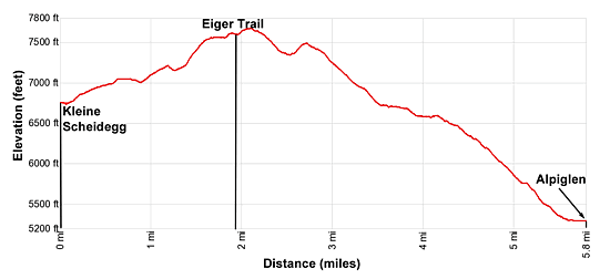
- Elevation: 6,762-ft. - 7,612-ft.
- Elevation Gain: 850-ft. - 850-ft.
- Difficulty: moderate
- Trail Highlights: See Trail Intro
- Basecamp(s): Grindelwald
- Region: The Bernese Oberland
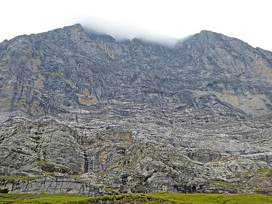
This interesting hike travels along the base of the Eiger with up-close and dramatic views of the iconic peak's sheer north face along with fine views of the Grindelwald Valley and nearby summits. Several options extend the hike, adding to the scenic delights of the day.
Eiger Trail: Eigergletscher to Alpiglen
Note: When riding the train to the Eigergletscher stop you must push the button requesting that the conductor stop at the station. (The stop is what the Swiss refer to as a “Halt on Demand” station.) Announcements will be made in English, along with a few other languages, telling you to request the stop. After the announcement push the halt on demand button and then quickly get off the train when it stops.
At the Eigergletscher train station walk west (toward Kleine Scheidegg) along the tracks, cross to the east side of the tracks at the pedestrian crossing and then follow the signs for the Eiger Trail. The path weaves between buildings and then turns right (east/northeast), ascending along rocky slopes beneath the steep cliffs of the Eiger’s west ridge. Along the way the trail passes under a ski lift and then travels by a wall with plaques honoring famous climbers who have attempted to climb the Eiger's north face.
Beyond the plaques the trail descends scree covered slopes on steep grades, crosses a small bowl and then ascends to the top of a low ridge. The Eiger’s north face looms overhead. In the distance are fine views of the Wetterhorn towering above Grosse Scheidegg.
After a brief respite atop the ridge the trail descends scree covered slopes on moderately steep to steep grades. In places the scree gives way to rocky meadows and the footing improves. Depending on the time of year patches of snow and ice still cling to the rugged cliffs above the trail.
Views along the trail continually evolve. To the north a ridge, anchored by the Faulhorn, forms the scenic backdrop for Grindelwald sprawled along the valley floor. The Schwarzhorn, Grosse Scheidegg and the Wetterhorn rim the valley to the northeast. Behind you the Lauberhorn, Tschuggen and Mannlichen fill the skyline. The Eiger’s north face soars above the trail.
After 1.6 miles the grade abates. The path now travels through meadows, crossing a few seasonal streams and passing by small waterfalls. Boulders in the meadows offer good perches for taking a break while enjoying the views. After half a mile the trail resumes its descent on moderately-steep to steep grades.
At 2.7 miles the trail reaches a photogenic waterfall. Here the trail curves to the left and drops down a series of switchbacks. The descent is accompanied by good views of a series of waterfalls and deep fissures channeling small streams. Your perspective of the Eiger has now changed so that you have a good view of the top of the peak.
Reach a junction at 3.1 miles. Here the trail to the Gletscherschlucht and Grindelwald (2-hr 25-min) branches to the right. We continue along the trail toward to Alpiglen (25-min).
After one more set of switchback the trail descends on steep to moderately-steep grades through meadows, dropping down some stone steps, to the train station at Alpiglen at 3.8 miles. Here a small station sells return tickets to the Grindelwald Bahnhof.
Kleine Scheidegg to the Eiger Trail
My preferred option is to walk from Kleine Scheidegg to the start of the Eiger Trail at the Eigergletscher Train Station. Upon arriving at Kleine Scheidegg cross to the south side of the rail tracks and locate the trail signs near the base of the steps leading to the Hotel Bellevue des Alps, an old wood hotel. Follow the signs pointing to the Eigergletscher (Eiger Glacier), directing you to climb the stairs and then turn right, following a broad track ascending on moderate grades above the left (east) side of the train tracks for the Jungfraujoch.
Ahead are great views of the glaciers spilling down the slopes of the Jungfrau and the Monch along with the high peaks towering above the Sefinental valley to the west of Lauterbrunnen. The Lauberhorn rises to the northwest.
Reach the Fallbodensee, a pretty little lake, at 0.6 miles. On a still day the mirror-like surface of the lake is a photographer’s dream, perfectly reflecting the Wetterhorn and the Eiger. On the south side of the lake a small building houses an interesting exhibit showing the various routes climbing the Eiger’s north wall. It’s definitely worth a stop.
At the southeast end of the lake the trail turns right (south) and drops down a gravel track, passing through a culvert going under the train tracks. Beyond the culvert the trail heads south/southwest, resuming its ascent on moderate to moderately-steep grades.
Reach at junction at 1.1 miles. To trail to the left (east) heads directly to the Eigergletscher train station and the start of the Eiger trail (the short route – 1.4 miles). The trail straight ahead leads to the moraine of the Eigergletscher and then the train station (the long route – 1.9 miles).
To take the short route turn left (east) and climb switchbacks through pastures, passing over an underground railway tunnel. A short distance to the west of the trail you will see where the trains emerge from the tunnel.
Soon the path climbs above the north side of the train tracks, passes along the backside of the Eigergletscher Railway buildings and reaches the Eiger Trail at 1.4 miles.
The longer route to the train station continues straight ahead at the junction and soon crosses a low ridge. Here the trail curves to the left (southeast) as it drops into a shallow bowl and then climbs to an overlook atop the Eiger Glacier’s moraine at 1.4 miles. The overlook features stunning views of Eiger Glacier clinging to the rugged slopes between the Eiger and the Monch.
Walk up the moraine toward the Eigergletscher train station. Progress will be slow as you stop frequently to enjoy the spectacle.
At 1.7 miles turn left on a trail that descends from the moraine and soon arrives at the Eigergletscher train station. Walk west (toward Kleine Scheidegg) a short distance along the tracks to the pedestrian crossing and cross to the east side of the tracks. Here you will find trail signs pointing to the Eiger Trail and Alpiglen. The path travels between the buildings and reaches the start of the trail at 1.9 miles.
Trail Distances:
- Eiger Trail (Eigergletscher) to Alpiglen: 3.8 miles
- Eiger Trail plus the walk from Kleine Scheidegg to the start of the trail: 5.2 to 5.7 miles
- Walking from Mannlichen to Kleine Scheidegg adds 2.8 miles to the day for an 8.0 to 8.5 mile hike. For more information see the Panoramaweg: Mannlichen to Kleine Scheidegg trail description.
Elevation Profile
Driving Directions
From Grindelwald to the Eiger Station via the Eiger Express Gondola: From the Grindelwald train station walk a short distance to the east along the main street to the main bus stop on the south side of the road and catch the #121 bus to Terminal or #123 bus toward Itramen Egg. Get off at the Terminal stop where a new facility includes the valley stations for the Mannlichen and Eiger Express gondolas. The bus rides take about 13 minutes. You can also take the train from Grindelwald Bahnhof to Grindelwald Terminal. The ride takes five minutes. Purchase one-way tickets on the Eiger Express Gondola to the Eiger Station. The ride takes about 20 minutes. Note: Expect the 26-person gondolas to be crowded with people heading to the Jungfraujoch.
Alternatively, from the train station follow the yellow signs pointing to the Terminal station for the Mannlichen and Eiger Express gondolas, which is to the northwest of the Grund Station on the Kleine Scheidegg line. The walk descends the hillsides to the south/southwest of the train station, using a combination of walkways and roads to the Terminal Station. Allocate about 20 minutes for the 0.9 mile walk. Purchase one-way tickets on the Eiger Express Gondola to the Eiger Station. The ride takes about 20 minutes. Note: Expect the 26-person gondolas to be crowded with people heading to the Jungfraujoch.
From Grindelwald to Kleine Scheidegg / Eigergletscher Train Station (2 Trains): Walk to the Grindelwald Bahnhof at the east end of town and take the cog railway to Kleine Scheidegg. In the summer trains generally run every 30 minutes. Get off a Kleine Scheidegg and walk to the south side of the station where you will find the trains heading to the Jungfraujoch. Get on a train heading toward the Jungfraujoch and get off at the Eiger station, the first stop. This is a “Stop on Demand” meaning you need to push the button near the exit door that signals to the conductor that you wish to get off the train. Announcements in English, along with a number of other languages, will tell you when to push the button. The entire ride should take about 50 minutes.
Kleine Scheidegg is a very busy place and boarding the train to the Jungfraujoch can be a tad chaotic. Some cars on the train heading to the Jungfraujoch are reserved for large groups (signs in the windows). Train personnel along the track can direct you to the cars open to the general public.
If you are walking from Kleine Scheidegg to the start of the Eiger Trail, get off the train at Kleine Scheidegg, walk to the south side of the train station and then walk east (toward Grindelwald) to the Hotel des Alpes, a large wood hotel. Here you will find signposts directing to the trail heading to the Eigergletscher train station.
From the Grindelwald Bahnhof (train station) to Mannlichen: From the Grindelwald train station walk a short distance to the east along the main street to the main bus stop on the south side of the road and catch the #121 bus to Terminal or #123 bus toward Itramen Egg. Get off at the Terminal stop where a new facility includes the valley stations for the Mannlichen and Eiger Express gondolas. The bus rides take 8-12 minutes. You can also take the train from Grindelwald Bahnhof to Grindelwald Terminal. The ride takes five minutes.
Alternatively, from the train station follow the yellow signs pointing to the Terminal station for the Mannlichen and Eiger Express gondolas, which is to the northwest of the Grund Station on the Kleine Scheidegg line. The walk descends the hillsides to the south/southwest of the train station, using a combination of walkways and roads to the Terminal Station, a new facility for the Mannlichen and Eiger Express Gondolas. Allocate about 20 minutes for the 0.9 mile walk. The ride up the world’s longest passenger-carrying gondola takes about 30 minutes and is quite scenic.
Trail Resources
Trail Intro / Trail Photo Gallery / Trail Map
Basecamp(s) Information:
Grindelwald
Region Information:
The Bernese Oberland
Other Hiking Regions in:
Switzerland