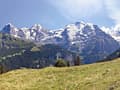
Best Hikes in The Bernese Oberland
Featured Hikes
Distance: 7.7 - 8.6 miles (One Way)
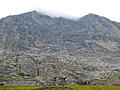
The best hike in Lauterbrunnen climbs steeply to Tanzbodeli, an overlook atop a grassy plateau with jaw-dropping, panoramic views of the high peaks towering above the Lauterbrunnen and Sefinen Valleys. The return via Obersteinberg is packed with visual delights.
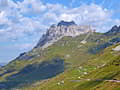
Altdorf to Engelberg via Surenen Pass ![]()
Distance: 8.9 - 13.0 miles (One Way)
The Alpine Pass Route from Altdorf to Engelberg ascends through meadows framed by rugged peaks to Surenen Pass where Titlis and the Schloss and Spannort massifs dominate the view. The scenic descent to Engelberg features views of towering, jagged peaks adorn with waterfalls and a dramatic cirque.
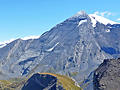
Distance: 10.2 miles (One Way)
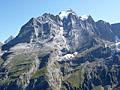
One of the best hikes in the Grindelwald area features fabulous views of the Bernese Alps stretching from the Wetterhorn, Eiger, Jungfrau and Breithorn, towering above the Grindelwald and Lauterbrunnen Valleys, to the Bluemlisalp massif in the southwest.
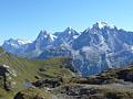
Distance: 10.8 miles (One Way)
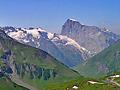
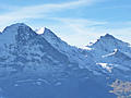
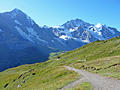
A triad of giants; the Eiger, Monch and Jungfrau, dominate the breathtaking views along this scenic hike from Mannlichen to Wengen.
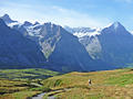
Distance: 9.8 - 10.4 miles (Round Trip)
Hikers tackling the steep, strenuous ascent to Hohturli Pass are rewarded with stunning vistas of Oeschinensee Lake, marvelous mountain scenery and close-up views of dramatic glaciers.
Distance: 9.6 - 12.0 miles (Round Trip)
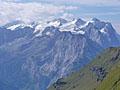
This long, challenging hike visits the lovely Brunnital and then ascends a wild, seldom visited valley to Hoch Fulen, a summit with stunning views of the Schachental Mountains, the Glarus Alps, including the Scharhorn, Clariden and Gross Windgallen, and the summits towering above the Reuss Valley to the west.
Distance: 9.5 - 13.9 miles (One Way)
Running between Klausen Pass and Altdorf, the Schachental Hohenweg trail travels high above the north side of the Schachental Valley in the Schwyz Alps with panoramic views of the Glarus Alps to the south and the rugged cliffs of the Schachentaler Windgallen massif towering overhead
Distance: 8.4 - 12.0 miles (Round Trip)
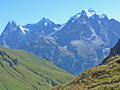
This beautiful walk showcases the high peaks soaring above the Lauterbrunnen and Sefinen valleys. The trail ascends through pretty meadows with nonstop views to Rotstock Hut and then climbs a wild valley to the Sefinenfurgge Pass where vistas open to the Kiental valley and beyond.
Kandersteg (Sunnbuel) to Adelboden ![]()
Distance: 7.3 miles (One Way)
This challenging trail features panoramic views of the high peaks towering above the Spittelmatte, Uschene and Engstligenalp Valleys. The path is best suited for sure footed hikers who like demanding trails that cross exposed passes, travel along airy ridges and include steep ascents and descents.
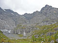
Murren to Griesalp via the Sefinenfurgge ![]()
Distance: 10.4 miles (One Way)
This splendid hike over Sefinenfurgge Pass, the second highest pass on the Alpine Pass Route, enjoys impressive views of the high peaks towering above the Lauterbrunnen, Sefinen and Kiental Valleys.
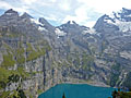
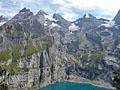
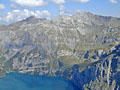
Distance: 5.2 miles (Loop)
This terrific loop hike features ever-evolving views of the magnificent glacial cirque towering above the Oeschinensee, one of the most beautiful lakes in the Swiss Alps.
Distance: 3.5 - 8.9 miles (One Way)
Panoramic views of the 4,000-meter peaks, glacial cirques and deep gorges to the south of Grindelwald are the highlights of this terrific hike between Grosse Scheidegg and Bussalp.
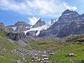
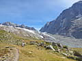
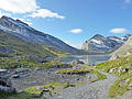
Griesalp to Kandersteg via Hohturli ![]()
Distance: 9.1 miles (One Way)
The challenging hike over Hohturli Pass features captivating vistas of the high peaks towering above the Kiental and Kandertal valleys, front row seats to the dazzling Bluemlisalp Glacier and stunning views of the rugged cirque soaring above the Oeschinensee, one of the most beautiful lakes in Switzerland.
Distance: 6.4 miles (Round Trip)
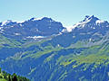
The beautiful hike from Engstlenalp to Planplatten visits the scenic Tannersee, enjoys terrific views atop the Balmeregghorn and then travels to the overlook at Planplatten with panoramic vistas of the high peaks towering above four valleys.
Distance: 10.8 - 12.8 miles (One Way)
Soaring peaks, a glacier-clad cirque, pretty villages, and nonstop views are the hallmarks of this scenic hike traveling high above the north side of the Lötschental. Views stretch up the length of the panoramic valley and south to the high peaks towering above the Valais.
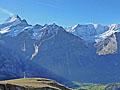
Distance: 7.2 miles (Round Trip)
Amazing views of the glacier clad peaks towering above Grindelwald and Lauterbrunnen along with views of Lake Brienz and beyond are the highlights of this popular trail climbing to the historic Faulhorn Berghaus and the summit of the Faulhorn.
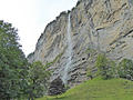
Lauterbrunnen to Trummelbach Falls ![]()
Distance: 2.2 - 4.4 miles (One Way)
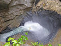
This lovely walk up the Lauterbrunnen Valley travels through emerald green meadows and passes photogenic waterfalls on the way to Trummelbach Falls, a World Heritage Site. The dramatic falls are a true natural wonder, showcasing a series of waterfalls thundering down a slot canyon carved into a mountain.
Panoramaweg: Mannlichen to Kleine Scheidegg ![]()
Distance: 2.8 miles (One Way)
The Panoramaweg, between Mannlichen and Kleine Scheidegg, is an easy, popular hike with nonstop views the Eiger, Monch and Jungfrau. Extend the hike with a walk to the Mannlichen summit for more breathtaking views.
Distance: 3.8 miles (Round Trip)
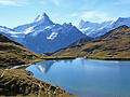
This very popular hike packs a ton of scenery into a very short distance. Nonstop views encompass Grindalwald’s iconic peaks towering above the south side of the valley. These summits form the backdrop for the Bachsee, a gorgeous lake set amid beautiful alpine meadows.
Distance: 3.5 - 5.0 miles (One Way)
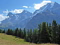
The Mountain View Trail, from Grutschalp to Allmendhubel to Murren, features stunning views of the Eiger, Monch and Jungfrau along with the glacier-clad peaks rimming the cirque at the head of the Lauterbrunnen Valley
Distance: 4.0 - 7.3 miles (Loop)
This beautiful hike ascends through scenic meadows with nonstop views of the glacier-clad peaks rising above the upper Lötschental. Along the way the path passes three pretty lakes, travels beside sections of the Lonza River and visits Anenhutte (Anen Hut).
Distance: 3.5 miles (One Way)
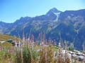
The trail between Grosse Scheidegg and First follows an undulated path through bucolic meadows with evolving, panoramic views of the massive peaks, adorn with glistening glaciers, towering above the Grindelwald Valley. Along the way waterfalls, wildflowers and small alps add interest to the hike.
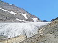
Distance: 3.3 - 8.4 miles (Round Trip)
This scenic hike travels up the rugged Gasterntal (Gastern Valley) and then climbs steeply to viewpoints above the Kanderfirn Glacier. Two shorter versions of the hike offer beautiful views of the valley while avoiding the steep ascent to the glacier overlook.
Distance: 5.8 miles (One Way)
This popular, easy segment of the Lötschentaler Höhenweg, a high route along the north side of the Lötschental (Lötschen Valley), travels through lovely meadows, beautiful larch forests and bucolic villages accompanied by panoramic views of the glacier-clad peaks rimming the valley.
Distance: 3.8 - 8.5 miles (One Way)
This interesting hike travels along the base of the Eiger with up-close and dramatic views of the iconic peak's sheer north face along with fine views of the Grindelwald Valley and nearby summits. Several options extend the hike, adding to the scenic delights of the day.
Golzern - Hohenweg Maderanertal ![]()
Distance: 5.0 - 9.8 miles (Loop)
This is another of Switzerland's wonderful high routes with almost nonstop views. The trail loops around the Maderanertal, a pristine valley surrounds by soaring mountains, visiting the Windgallen Hut along the way. Waterfalls, wildflowers and small hamlets add interest to the hike.
Ammerten Pass and the Ammertenspitz ![]()
Distance: 5.5 - 6.5 miles (Round Trip)
Ascend the beautiful Engstligenalp valley to scenic Ammerten Pass with great views of the peaks surrounding the valley and the mountains rising to the south. From the pass a steep trail leads to the Ammertenspitz summit with panoramic views encompassing the summits towering above Adelboden, Lenk and beyond.
Distance: 6.7 - 10.2 miles (Loop)
This loop hike travels to Obersteinberg, a pretty alp with impressive views of the glacier-clad summits rimming the head of the Lauterbrunnen Valley. Views stretch from the Jungfrau in the north to the Breithorn and Tschingelhorn in the south. Extend the hike with a trip to the Oberhornsee, a small lake.
Distance: 5.8 - 8.9 miles (Round Trip)
The Chilchbalm, a pretty glacial basin, lies beneath the rugged cirque at the head of the Sefinen Valley. The trail leading to the basin is perfect for anyone looking for a peaceful, relatively easy day hike accompanied by fine views of the Sefinen Lutschine (stream) and the rugged peaks rimming the Sefinen Valley.
Distance: 10.8 miles (Round Trip)
This trail travels up a pretty valley, rimmed by rugged cliffs and soaring peaks, passes the Daubensee, a photogenic lake, and then climbs to Gemmi Pass with panoramic views of the high peaks in the Valais, stretching from Monte Rosa to Dent Blanche and beyond.
Distance: 4.3 - 8.6 miles (One Way)
This easy hike travels up the enchanting Lauterbrunnen Valley, a classic glacial valley rimmed with sheer cliffs and soaring glacier-clad peaks, passing many beautiful waterfalls on its way to Stechelberg near the head of the valley. Lovely meadows, small alps and the Weisse Lutschine River add to the scenic delights.
Distance: 4.4 miles (Round Trip)
Hikers completing the very steep climb to the summit of the Bunderspitz are rewarded with amazing views of the cirque soaring above the Oeschinensee along with the high peaks towering above the head of the Kandertal and Adelboden (Engstligental) Valleys.
Distance: 7.8 miles (Round Trip)
Trail Closed
Frunden Hut is set atop a rock knoll beneath the Frundenhorn and Frunden Glacier, over 3,200-ft. above the Oeschinensee, a beautiful lake. Dramatic views from the overlook encompass the Bluemlisalp massif, adorn with glaciers, along with the high peaks towering above the north side of the lake.
Klausen Pass - Äsch - Unterschächen ![]()
Distance: 7.0 miles (One Way)
This scenic hike, traveling through lovely meadows, along rugged cliffs and beside rushing streams, features great views of the high peak rimming the Schächental Valley, the beautiful alps of Chammli, Oberalp and Ä and dramatic Stauben Falls.
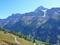
Distance: 4.0 miles (Round Trip)
A very steep climb leads to First, a great overlook high above the west side of Kandersteg, with 360-degree views of the high peaks towering above Oeschinensee, Spittelmatte and the Adelboden (Engstligental) Valleys.
Lauchernalp to Faldumalp to Ferden ![]()
Distance: 7.1 miles (One Way)
This hike travels between Lauchernalp, Faldumalp and Ferden on a segment of the Lötschentaler Höhenweg . Highlights include grand views of the glacier-clade peak rimming the Lötschental, lovely meadows, pretty villages, and gushing streams.
Distance: 3.5 miles (One Way)
This short, easy walk along a high bench on the west side of the Lauterbrunnen Valley features terrific views of the big three: the Eiger, Monch and the Jungfrau, along with the Abeni Flue, Mittaghorn and the Grosshorn. The walk is a good option on a day when the weather precludes hikes at higher elevations.
View Hikes by Area:
GrindelwaldLauterbrunnenGriesalpKanderstegEngelbergMeiringenAltdorf
| Support our Site |
The Region, the Hikes & the Base Camps
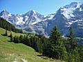
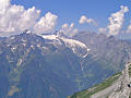
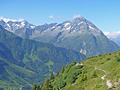
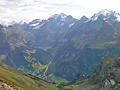
The Berner Oberland in western Switzerland is best known for the Bernese Alps. While not as high as the peaks in the Valais, this spectacular range is famous for a trio of massifs – the Eiger, Monch and the Jungfrau, along with splendid scenery and excellent hiking trails. The most spectacular portion of the Alpine Pass Route, a long distance hiking trail, passes through the heart of the Bernese Alps from Meiringen to Kandersteg. Each day the route travels through breathtaking scenery, crosses panoramic high passes and wanders through lush meadows sprinkled with wildflowers. Along the way hikers are treated to a diversity of Swiss villages from small hamlets, such as of Lauterbrunnen, to the popular ski resort of Grindelwald.
It should be noted that the region is rainier than the Valais but the extra moisture enhances the scenic beauty of the region with a verdant landscape creating magical contrasts with the rugged, glacier clad peaks.
Base Camp Information: Grindelwald / Lauterbrunnen / Griesalp / Kandersteg / Engelberg / Meiringen / Altdorf