Fafleralp to Anenhutte Loop 
Distance: 4.0 - 7.3 miles
near Kandersteg in The Bernese Oberland
By: Diane Greer
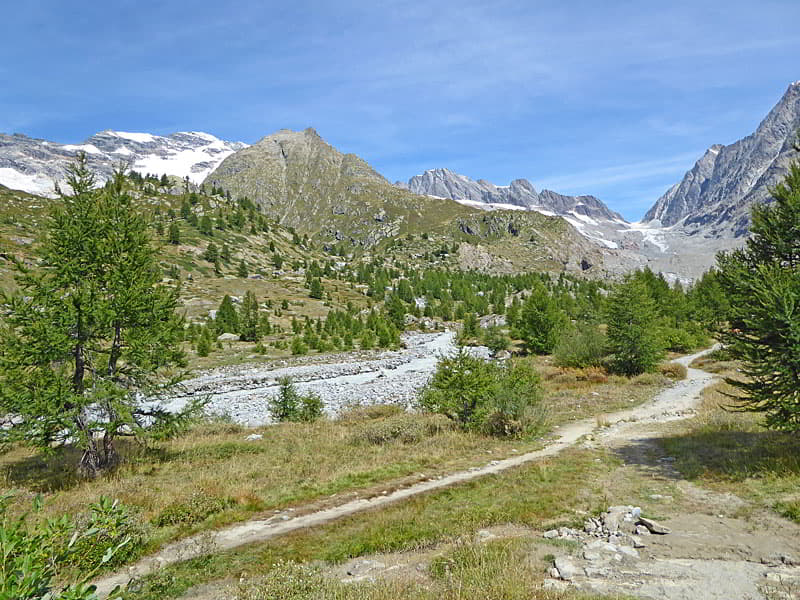
Views of the peaks and glaciers at the head of the valley
This beautiful hike ascends through scenic meadows with nonstop views of the glacier-clad peaks rising above the upper Lötschental. Along the way the path passes three pretty lakes, travels beside sections of the Lonza River and visits Anenhutte (Anen Hut).
- Distance: 4.0 - 7.3 miles (RT)
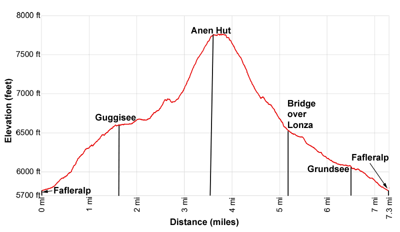
- Elevation: 5,730-ft. at Trailhead
Maximum elevation - 7,765-ft. - Elevation Gain: 2,035-ft.
- Difficulty: moderate-strenuous
- Basecamp: Kandersteg
- Region: The Bernese Oberland
Trail Description - Fafleralp to Anenhutte Loop
This scenic hike travels through a diverse landscape in the upper Lötschental Valley to Anenhutte (Anen Hut), a modern alpine hut set beneath the cirque at the head of the valley. From the hut enjoy panoramic views of the Lang and Anun glaciers flowing down the cirque’s rugged peaks.
There are two trails to Anenhutte (Anen Hut), both starting near the bus stop at Fafleralp. The first travels up the south side of the upper Lötschental (Loetschen Valley), passing the Gundsee, a popular lake. After 2.0 miles the path crosses a bridge over the Lonza River and then climbs steeply to Annenhutte. The second path ascends the slopes along the north side of the valley, passing Guggistafel, and the Guggisee, a small lake, before climbing steeply to the hut.
My advice is to use both trails to create a loop. The loop is a great hike in either direction. This description hikes in a clockwise direction, ascending the north side of the valley to the hut and then descending along the south side of the valley floor.
No matter which direction you choose to hike the day will be filled with amazing views of the high peaks rimming the upper Lötschental Valley and the glacier-clad cirque at the head of the valley. Along the way the trail passes three small lakes, travels beside the rushing Lonza Rover and visits Anen Hut.
Parties looking for a shorter day can simply walk up the south side of the valley floor as far as time and energy allow. This option visits the Grundsee and then ascends on moderate grades through pastures and rocky meadows toward the head of the valley where the path crosses the Lonza River on a bridge. Turning around at this point avoids the steep climbs to the hut for a 4.0 mile (6.4 km) hike.
The Loop Hike from Fafleralp to Anenhutte

The day starts by taking the bus to Fafleralp. (See trailhead directions below.) The bus stop is adjacent to the trailhead where signs point northeast up a broad track toward the Grundsee, Guggistafel and Anenhutte. The broad path passes Gletscherstafel, a small hamlet, and then reaches a junction adjacent to a bridge over the Lonza River. Here the trail split. We bear left on the path toward Guggistafel (35 min), Guggisee (1h) and Anenhutte (2hr 10 min). Our return route, the trail heading to the Grundsee, turns right and crosses the bridge.
Beyond the junction the path ascends through scattered trees along the north side of the valley, crossing a small stream along the way. Turn left at a junction at 0.75 miles (1.2 km) toward the Anensee, Guggisee and Guggistafel. The trail straight ahead is signed for Anenhutte but takes a lower route that is not as scenic.
Our path climbs a switchback and arrives at a junction at Guggistafel at 1.0 mile (1.6 km). Turn right here onto trail #182 toward the Guggisee and Anenhutte (1hr 35min). The trail now travels through trees and then meadows atop a low ridge with ever improving views of the glacier-clad Lonzahoner, Lötschental er Breithorn and Breitlauihorn rimming the south side of the valley. The summit of the Bietschhorn peeks above the ridge to the southwest. Soon views open to the Burstspitza, rising above the trail to the north. Behind you are great views of the high peaks lining the western end of the Lötschental .
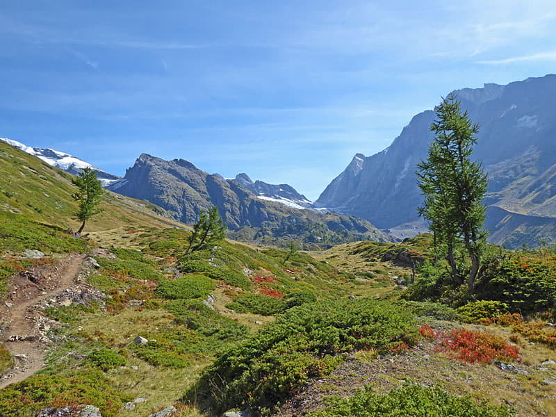
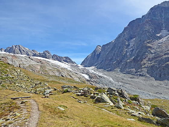
Soon the path drops off the ridge, crosses a small stream and then continues heading up valley through the scenic meadows of Gugginalp, accompanied by beautiful views of the Sattelhorn and the Anuchnubel towering above the head of the valley. The Lotschenlucke, a high pass between the two peaks, links the Lötschental to the valley of the Aletsch Glacier. The rugged Jegichnubel, along with an ice-clad ridge of the Grosshorn, rise above the north side of the valley.
At 1.5 miles (2.4 km) the grade abates and soon reaches the Guggisee, a small lake, at 1.6 miles (2.6 km). Across the valley the Lonzahoner and Lötschental er Breithorn dominate the view. A short distance beyond the trail goes by a junction where the lower path, we passed on the way to Guggistafel, joins with our trail.
As we continue up valley views open northeast to the ice-clad slopes of the Grosshorn, towering above the Jegital, a tributary valley branching north from the Lötschental . The rugged slopes of the Burstspitza loom overhead. Be sure to turn around occasionally for great views down valley.
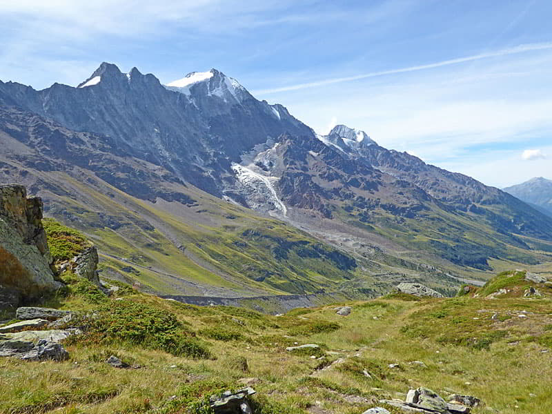
At 2.2 miles the grade steepens as the path climbs the slopes of the old moraine along the west side of the Jegital. Along the way views open to the summits of the Breithorn and the Grosshorn, anchoring the cirque at the head of the Jegital. These peaks also rim the cirque at the head of the Lauterbrunnen Valley in the Bernese Oberland to the north.
At 2.5 miles (4.0 km) the grade abates as the trail curves to the left (northeast), traveling beside the Jegibach, the stream draining the Jegital. Soon the path descends gently and crosses a bridge over the Jegital.
Beyond the bridge reach a junction at 2.8 miles (4.5 km). Here we bear left on the trail toward Anenehutte and the Anensee. The trail to the right (#182) descends to the valley floor and heads back to Fafleralp. We will use this trail on the return leg of the hike. This trail is also a good option for cutting the hike short if the weather is taking a turn for the worse.
The path now ascends steep switchbacks up slopes clad in meadows and low-lying shrubs. As you gain altitude great views open to the Breithorn at the head of the Jegital. The Jegichnubel looms overhead. Soon the path curves around the south ridge of the Jegichnubel, exiting the Jegital.
The steep ascent continues up the north side of the Lötschental with fine views of the peaks rimming the south side of the valley. Below the trail the Lonza River tumbles down broad glacial outwash plain dug by the retreating Lang Glacier. Turn around for great views that extend down the valley.
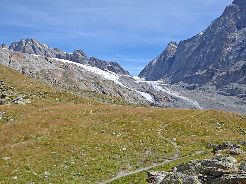
At 3.6 miles (5.8 km) the grade abates as the trail reach Anenhutte, a modern aluminum-clad structure, offering meals and dormitory accommodations along with a few high-end suites. The trail continues beyond the hut with panoramic views of the Langgletscher (Lang Glacier) flowing down the slopes between the Sattlehorn and the Anuchnubel. The Anungletscher (Anun Glacier) spills down the slopes of the Grosshorn and Mittaghorn into the Lang Glacier. The Jegichnubel towers overhead.
A short distance beyond the hut is the Anensee, a small pond. The trail soon comes to a junction and a good turn around point. From here a route ascends steeply up the moraine along the west side of the Anun Glacier.
The junction is a good place to find a place to sit, enjoy the views and meet the local goat herd. With a zoom lens or binoculars you should be able to pick out the Hollandiahutte located above the north slopes of the Lotschenlucke, the pass between the Sattelhorn and Anuchnubel.
When you are done enjoying the views, retrace your steps to the junction near the Jegibach at 4.5 miles (7.25 km). Here we turn left on trail #182 toward Fafleralp. The path descends the rugged hillside on moderately steep grades. At all junctions stay on the trail toward Fafleralp.
At 5.2 miles (8.4 km) cross the bridge over the Lonza River to the south side of the valley. Here nice views extend up valley to the Lang Glacier and the high peaks rimming the cirque at the head of the valley. To the north the Breithorn and the Grosshorn tower above the Jegital. To the south the Dischlig Glacier spills down the slopes beneath the Lonzahoner and Lötschental er Breithorn. These views will expand and evolve as you head down the valley beside the rushing Lonza River.
The trail now descends the valley on moderate grades, traveling through meadows and scattered trees. At 5.9 miles (9.5 km) the path crosses a bridge over the Beichbach, the stream fed by meltwater from the Dischling Glacier. A short distance beyond a second bridge crosses a tributary stream.
At a junction at 6.2 miles (10.0 km) bear left on the trail heading toward the Grundsee. The unmarked trail to the right, which is shorter and travels along the Lonza, will also get your back to the bus stop at Fafleralp but does not visit the Grundsee.
Reach the Grundsee at 6.5 miles (10.5 km). The small lake is very popular. On a nice day expect to see the lakeshore filled with visitors picnicking and taking in the views. The path travels along the lakes shore and then continues its descent to a bridge crossing the Lonza. Cross the bridge, turn left and then walk a short distance to the bus stop at Fafleralp at 7.3 miles (11.7 km).
Elevation Profile
Driving Directions
Note: The shortest and easiest access to this hike is to stay in the Lötschental (Lotschen Valley) and take the bus heading up valley to Fafleralp. The valley is also a fine day trip from many destinations along the main Valais train line from Sion or Brig. Thanks to the Lötschbergtunnel, this hike is also easily reached from Kandersteg in the Bernese Oberland.
From Wiler in the Lötschental: Take the #591 bus in the direction of Flafleralp and get off at the last stop, located at the east end of the large parking area (23 minutes). Bus scheduled are available online on the SBB website or the SBB app.
From Kandersteg (Bernese Oberland): From the Kandersteg Bahnhof take the train in the direction of Brig and get off at Goppenstein (about 13 minutes). Find the stairs that lead under the train tracks to the bus stop on the east side of the Goppenstein Bahnhof. Board the bus bound for Fafleralp. Get off at Fafleralp, the last stop located at the east end of a large parking area. The bus ride takes about 33 minutes. There are very good connections between the train and the bus in both directions. Train and bus schedule are available online on the SBB website or the SBB app.
Trail Resources
- Trail Photo Gallery
- Trail Maps
- Basecamp(s) Information: Kandersteg
- Region Information: The Bernese Oberland
- Other Hiking Regions in: Switzerland