Details: Sefinenfurgge Pass 
Distance: 8.4 - 12.0 miles (round trip)
Bernese Oberland, near Lauterbrunnen in The Bernese Oberland
By: Diane Greer
Hike Facts
- Distance: 8.4 - 12.0 miles (round trip)
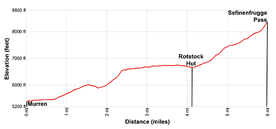
- Elevation: 5,374-ft. - 8,570-ft.
- Elevation Gain: 1,326-ft. - 3,196-ft.
- Difficulty: strenuous
- Trail Highlights: See Trail Intro
- Basecamp(s): Lauterbrunnen
- Region: The Bernese Oberland
This beautiful walk showcases the high peaks soaring above the Lauterbrunnen and Sefinen valleys. The trail ascends through pretty meadows with nonstop views to Rotstock Hut and then climbs a wild valley to the Sefinenfurgge Pass where vistas open to the Kiental valley and beyond.
To Rotstock Hut
Distance from Trailhead: 8.4 miles (round trip)
Ending/Highest Elevation: 6,700-ft.
Elevation Gain: 1,326-ft.
Note: If starting from the Murren mid-station on the Schilthornbahn (cable car), subtract 0.6 miles from the trail distances in this description. (See trailhead directions below.)
The hike to Sefinenfurgge Pass starts by taking the Lauterbrunnen to Murren Bergbahn, which includes a cable car to Grutschalp and then a train ride to Murren. (See trailhead directions below.) From the Murren train station, located at the north end of the village, walk south/southwest along the paved road through the village in the direction of the Schilthornbahn, Rotstockhutte, Sefinenfurgge and Griesalp. The Eiger, Monch and the summit of the Jungfau dominate the view across the Lauterbrunnen Valley to the east.
At 0.6 miles pass the mid station for the Schilthornbahn (cable car) in Murren. Just beyond the station signs point to a road heading southwest toward Spielboden, Rotstockhutte, Sefinenfurgge and Griesalp. Follow the paved track as it ascends on moderate grades through pastures, passing small alps (farms) along the way.
At 1.4 miles pass a trail branching left (south), which drops to Gimmelwald and Stechelberg. A short distance beyond ignore the trail branching right (northwest) toward Blumental, Allmendhubel and the Schilthorn. Views now open to the peaks rising above the Sefinental (Sefinen Valley) to the southwest. Birg and the Schilthorn dominate the view to the west.
Turn left on a trail signed for Spielboden, Sefinenfurgge and Griesalp at 1.7 miles. The trail drops steeply down the hillside, crosses a bridge over the Schilthornbach (Schilthorn stream) and then skirts the north and east sides of the restaurant at Spielbodenalp (5,882-ft.). In front of the restaurant, signs point to a trail heading left (southeast) to Gimmelwald and Murren. We continue along the narrow trail branching right (south) toward Sefinenfurgge and Griesalp.
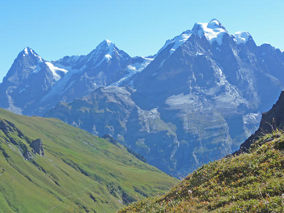
At 2.0 miles the trail curves to the right (west) and ascends steep, tight switchbacks up the end of the Wasenegg ridge. Reach the top of the switchbacks after gaining over 600-ft. The trail now curves around the head of the ridge and enters the Sefinental. From an overlook at 2.4 miles enjoy terrific views of the Gspaltenhorn, Tschingelspitz and Butlasse towering above the Sefinental. The Monch, Eiger, and Wetterhorn dominate the view to the east while the Grosshorn and Breithorn rise above the head of the Lauterbrunnen valley to the southeast.
Past the viewpoint reach a junction with a trail branching right (north) that climbs steeply to the Bryndi viewpoint atop the ridge. Continue straight ahead (west) on the main trail, contouring along the grassy slopes on the north side of the valley. Views soon open to Sefinenfurgge Pass, the saddle on the ridge at the head of the valley.
Pass a trail on the left (southwest) at 2.7 miles dropping down to Oberberg and Gimmelwald. We stay on the main trail that wanders through pretty pastures with wonderful, bird’s-eye views of the cirque formed by Tschingelspitz, the Gspaltenhorn and Butlasse to the southwest. An interesting horn rises at the end of a ridge jutting into the valley. The Schilthorn towers above the high meadows to the northwest. Behind you are terrific views of the peaks lining the east wall of the Lauterbrunnen Valley.
Reach Oberlager (6,729-ft.) at 3.5 miles. Here a trail branches right (northeast) toward Schiltalp and Murren. We continue straight ahead, contouring around a minor ridge and then descending on easy grades toward Rotstockhutte, set atop a grassy knoll.
Near the hut the path curves to the southwest, crosses a stream and soon reaches a junction at Boganggenalp / Rotstockhutte (6,690-ft.) at 4.1 miles. Here a trail branches left (southeast) toward Stechelberg and Gimmelwald.
Cross two more streams and then climb to a junction at 4.2 miles with a trail branching left to the hut. The hut is a good turnaround for parties looking for a shorter day (8.4 miles round-trip) or if the weather is taking a turn for the worse. The hut, which offers refreshments and accommodations, features terrific views of the high peaks soaring above the Lauterbrunnen Valley along with the Schilthorn and summits to the north.
To Sefinenfurgge Pass
Distance from Trailhead: 12.0 miles (round trip)
Ending/Highest Elevation: 8,570-ft.
Elevation Gain: 3,196-ft.
From the junction at Rotstock Hut, the trail to Sefinenfurgge Pass curves to the right (west) and climbs through rocky pastures on moderate grades. Red and white stakes and blazed rocks help keep you on track. The Schilthorn towers overhead to the north.
At 4.5 miles pass a trail branching right (northwest) toward Rote Hard and the Schilthorn. Our trail curves to the left (southwest), ascending very steep grades up rocky meadows. As you climb, turn around for splendid views of the Eiger, Monch and Jungfrau, along with nearby peaks rising above the east side of the Lauterbrunnen Valley.
Pass a second junction with a trail branching right (north) to Rote Hard and the Schilthorn at 5.0 miles. Just beyond the junction the grade eases as the trail enters a pretty hanging valley, bound to the south by the horn, seen earlier, rising above the end of a low ridge. The trail passes a small pond and then weaves its way through hillocks and high pastures, staying to the right (north) of a stream trickling down the valley floor.
Soon the grade steepens as the trail ascends along the north side of the valley. As you gain height enjoy wonderful views of the Wetterhorn, Eiger, Monch and Jungfrau. Ahead you can see Sefinenfurgge Pass, the notch on the ridge at the head of the valley.
At 5.7 miles the trail briefly drops into a small bowl and then climbs very steep switchbacks through sparse meadows that give way to dark, scree covered slopes. The Hundshorn towers above the trail to the north while behind you are more great views of the high peaks to the east.
A final short, very steep climb propels you to Sefinenfurgge Pass (8,570-ft.) at 6.0 miles. The pass, a notch on a knife-edge ridge, is very narrow. Walk up the ridge to the south of the pass to find a good place to sit and take in the views. Keep an eye out for chamoix often seen grazing on the slopes around the pass.
From the Sefinenfurgge, enjoy great views of the Wetterhorn, Eiger, Monch and Jungfrau. To the west the Armighorn and Dundenhorn fill the skyline above the Kiental Valley. Looking south the Bluemlisalp massif rises above a low ridge. The Hundshorn rises to the north while the Schilthorn dominates the view to the northeast.
When you are done enjoying the views, retrace your steps to the trailhead for a 12.0 mile round-trip hike.
The trail continues over the pass toward Griesalp, a stop on the Alpine Pass Route. See the Lauterbrunnen/Murren to Griesalp via the Sefinenfurgge trail description for more information.
Elevation Profile
Driving Directions
From the Lauterbrunnen Bahnhof: Across the street from the north end of the Lauterbrunnen Bahnhof (train station) find the Lauterbrunnen to Murren Bergbahn. Take the four minute cable car ride to the top station at Grutschalp where you change for the train to Murren, a 14 minute ride. The walk from the cable car to the train is short and you should have no problem making the connection.
The other option is to take the bus from the Lauterbrunnen Bahnhof to the Stechelberg Schilthornbahn. (The destination on the bus will say Stechelberg, which is a few stops beyond the Schilthornbahn.) There are several bus stops in the village, each with a posted timetable. Select the stop that makes sense based on the location of your accommodations.
At the Schilthornbahn station purchase a ticket for Murren, the second stop on the multi-stage cable car trip to the Schilthorn -- a popular viewpoint with a revolving restaurant.
Trail Resources
Trail Intro / Trail Photo Gallery / Trail Map
Basecamp(s) Information:
Lauterbrunnen
Region Information:
The Bernese Oberland
Other Hiking Regions in:
Switzerland