Morteratsch Glacier Viewpoint 
Distance: 3.6 - 5.0 miles
near St Moritz in Eastern Switzerland
By: Diane Greer
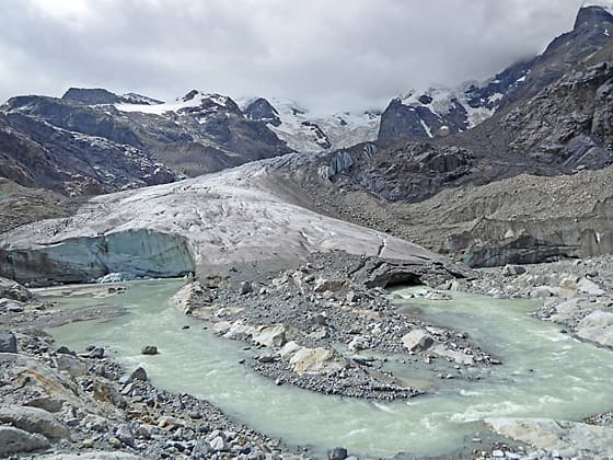
Meltwater flowing out of the glacial tongue
Learn about how receding glaciers change a landscape on this hike to the Morteratsch Glacier. After an easy stroll up the valley floor, the path turns rugged, climbing to a spectacular viewpoint of the glacial tongue framed by the soaring peaks of the Bernina range.
- Distance: 3.6 - 5.0 miles (RT)
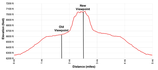
- Elevation: 6,250-ft. at Trailhead
Maximum elevation - 7,165-ft. - Elevation Gain: 915-ft.
- Difficulty: easy-moderate
- Basecamp: St Moritz
- Region: Eastern Switzerland
Trail Description - Morteratsch Glacier Viewpoint
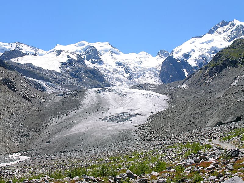
The Morteratsch Glacier, located near Pontresina, is one of the largest glaciers in eastern Switzerland and a vivid example of how climate change is altering Alpine landscapes. Between 1900 and 2017 the glacier has retreated over 8,000 feet. This distance is clearly illustrated with signs showing the glacier’s historic reach, turning the journey into a fascinating study of geology and global warming.
The trail initially follows a broad, easy path ascending the valley with great views of the ice-clad giants of the Bernina Range soaring above the head of the valley. Nearby the Morteratsch River rushes down the valley floor.
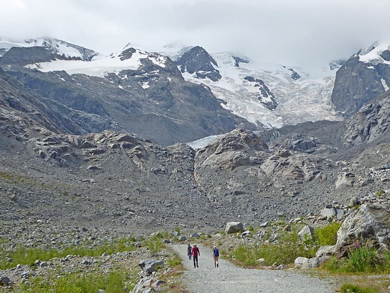
The easy part of the trail ends at an old viewpoint. In the past, the extent of the glacial tongue was easily viewed from this area. Today the glacier tongue can no longer be seen, now hidden behind a rocky ridge topped by glacial scoured rocks.
An extension to trail, added in 2023, now climbs through this rugged terrain on moderately-steep grades to a new viewpoint with dramatic, up-close perspectives of the glacial tongue. The extension adds 515-ft. and 1.4 miles (round trip) to the hike.
This is a great trail even if you choose not to hike the extension. The easy section of the path offers wonderful view of the high peaks of the Bernina Range and the Morteratsch River. A few benches and large rocks at the old viewpoint offer nice spots for a picnic or simply to take in the scenery.
This hike is a good alternative on days when clouds preclude hiking at higher elevations. While you will not see the peaks, the path up the valley to the glacial tongue is still a great destination.
To the Morteratsch Glacier Viewpoint
The path to the Morteratsch Glacier begins across from the Morteratsch train station. After carefully crossing the tracks, follow the wide dirt/gravel paths as it ascends the Morteratsch Valley on easy grades. The path travels beside the Morteratsch River (Ova da Morteratsch), a rushing torrent of glacial meltwater. The first 1.8 miles of this trail are well-maintained and suitable for both strollers and bicycles.
A short distance from the train station the trail passes through a sculpture, known as the Morteratsch Glacier Tear, representing a drop of melt water shed by the retreating glacier. The sculpture’s metal beams each produce a unique tonal sound when struck with a mallet.
In less that 0.1 miles pass a wood sculpture of a giant hand pointing right toward the Boval Hut and the Chunetta Viewpoint. At 0.7 mile go by a second trail branching right that also climbs to the Boval Hut and the Chunetta Viewpoint.
A Changing Landscape
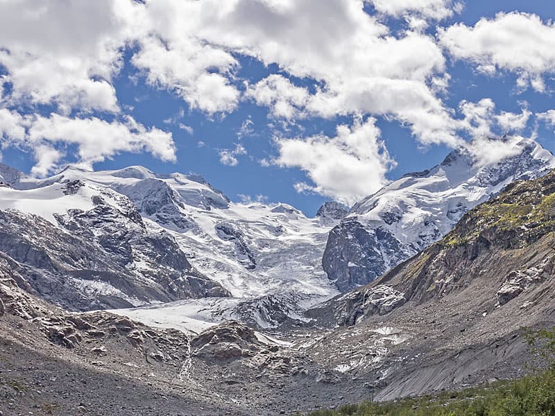
On a clear day the broad trail offers wonderful views of the glacier-clad peaks of the Bernina Range, including Piz Morteratsch, Piz Bernina, Piz Zupo, Bellavista and Crast Aguza. Be sure to turn around for views of Piz Albris rising to the north.
The path features 16 historic markers indicating the glacier's reach from 1900 to the present day. These signs provide a dramatic visualization of the retreat of the glacier due to climate change.
At 1.6 miles the impact becomes even more evident as you see a scree-covered ridge topped by glacially scoured rocks. Photos from 2007 show the ridge completely buried under ice. By 2019 the glacial tongue only extends partially down the right side of the largest rocks on the ridge top. Today, the glacier has retreated so far that it is now hidden behind the ridge.
Glacier tongue in 2007. - Hansueli Krapf This file is licensed under the Creative Commons Attribution-Share Alike 3.0 Unported license.
Glacier Tongue in 2019. - Dominicus Johannes Bergsma This file is licensed under the Creative Commons Attribution-Share Alike 4.0 International license.
Glacier tongue in 2025 now located behind the rocks. – Diane Greer, All Rights Reserved.
End of the Easy Trail
At 1.8 miles (400-ft of elevation gain) reach the end of the wide gravel path and the old viewing area. Braided channels of the Morteratsch River flow through the scree and curve around the viewpoint. A nearby marker places the farthest extent of the glacier in this area in 2015. Please note the sign warning of the dangers of rocks becoming dislodged from the glacier as it melts before you go any further.
This is a good turnaround point for casual hikers or anyone uncomfortable following a route through rugged terrain. A few benches and large nearby rocks offer nice spots for a picnic and to enjoy the scenery. A bike rack is provided for anyone who rode to this point and now wishes to hike to the final viewpoint.
New Trail Extension
A new trail extension, constructed in 2023, crosses a bridge over the river and continues to an overlook with great views of the glacier’s tongue at 2.5 miles. This boot beaten trail is more demanding than the easy walk up the valley, gaining 515-ft. in 0.7 miles.
Beyond the bridge, follow red and white markers indicating the path of the trail as its climbs through scree, ascends rock steps and then winds its way through a small rock couloir (gully). The route, which can be slippery at times, is best hiked by sure-footed hikers with proper hiking shoes.
The trail will continue to be rerouted as the glacier retreats. Use judgement and do not venture onto the ice or enter ice caves unless you are with a professional guide.
Chunetta Viewpoint Extension
Some trail description for this hike recommend taking the trail branching right at 0.1 miles to the Chunetta Viewpoint. Near the viewpoint a second trail descends back to the valley floor, rejoining the main trail at 0.7 miles from the start. The trip to the viewpoint adds 521-ft. of elevation gain and 0.3-miles to the hike. The view from Chunetta is nice, but somewhat obscured by trees.
A Harder Alternative
The trail to the Morteratsch Glacier starts at the same location at the hike to the Boval Hut, a much more demanding but highly recommended hike featuring spectacular views of the Morteratsch Glacier and the glacier-clad peaks of the Bernina Range soaring above the head of the valley.
Elevation Profile
Driving Directions
From St. Moritz to Morteratsch: Take the train from the St. Moritz Bahnhof to Morteratsch. Depending on the time of day the ride will take 24 to 28 minutes. Check the SBB website/SBB app for the current train schedule.
Trail Resources
- Trail Photo Gallery
- Trail Maps
- Basecamp(s) Information: St Moritz
- Region Information: Eastern Switzerland
- Other Hiking Regions in: Switzerland