Backpack: Big Sandy to Elkhart Park via Fremont and Highline Trails
Side Trip: Photo Pass Trail
Distance: 2.2 miles (one way)
Bridger Wilderness, Bridger-Teton National Forest, near Big Sandy in Wyoming's Wind River Range
By: Diane Greer
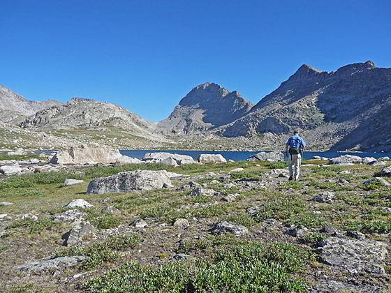
View of the Bewmark Lake basin and Photo Pass
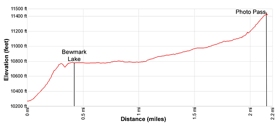
- Distance: 2.2 miles
- Elevation: 10,275-ft. at Junction Photo Pass Trail
10,765-ft. at Bewmark Lake
11,420-ft. at Photo Pass - Difficulty: strenuous
- Basecamp: Big Sandy / Elkhart Park
- Region: Wyoming's Wind River Range
Photo Pass Trail Description
Anyone visiting Middle Fork Lake is encouraged to take a side trip to Bewmark Lake and Photo Pass (aka Photographic Pass). This hike features great views of the peaks surrounding the Middle Fork Lake and the high summits ringing both sides of the Photo Pass basin.
From the foot of Middle Fork Lake head northeast along the lake’s north shore for 1.3 miles and cross Bewmark Lake’s outlet stream, which spills down the steep hillside to the north of Middle Fork Lake. Just beyond the crossing is an unmarked junction. Here the trail to Photo Pass branches left (north). To reach the Photo Pass trail from the head of Middle Fork Lake, head north/northwest for 0.6 miles along the lake’s eastern shore to the unmarked junction on the east side of Bewmark’s outlet stream.
For consistency sake the mileage in the description below starts at the junction at the base of the outlet stream. If coming from the foot of the lake, add 1.3 miles (one-way) to the mileage. Parties starting from the head of the lake should add 0.6 miles (one-way) to the mileage.
From the unmarked junction the Photo Pass trail ascends on very steep grades up the east side of Bewmark Lake’s outlet stream. As you ascend, enjoy panoramic views of the cirque at the head of the Middle Fork Valley and the high peaks surrounding the lake.
At 0.4 miles the grade abates as the trail reaches the bench cradling Bewmark Lake (10,765-ft.). As you crest the bench views open to Bewmark Lake set amid pretty alpine meadows and the high peaks surrounding Photo Pass including Odyssey Peak (12,062-ft.) and South Cleft Peak on the Continental Divide. Photo Pass is the saddle on the ridge to the west of South Cleft Peak. Peak 11,974 rises to the west of the pass while Peak 12,162 anchors the rugged ridge along the west side of the basin.
As you approach the lake shore you will see two paths, one trail turns right (east) at the foot of Bewmark Lake and climbs to Kagevah Pass (11,280-ft.). We turn left on a boot beaten path the crosses Bewmark Lake’s outlet stream and then heads north, traversing through rocky meadows along the west side of the lake.
Be sure to turn around for more great views of the cirque at the head of the Middle Fork Valley. Ahead are ever improving views of the high peaks surrounding the Bewmark Lake basin.
Beyond the head of Bewmark Lake the trail ascends on moderate grades through alpine meadows dotted with wildflowers. Along the way the path crosses to the east and then back to the west side of Bewmark’s inlet stream. As you ascend the valley look left (west) to see Lake 10,935 nestled in a rocky bowl.
The trail steepens as it approaches the head of the valley. At 1.8 miles the grade briefly abates as the trail travels through marshy meadows and crosses a small stream carrying snowmelt from the area around the pass.
At 1.9 miles the trail begins the steep climb to Photo Pass, ascending through rocky meadows that give way to scree covered slopes. Behind you the high peaks of the Middle Fork Valley form a scenic backdrop to the Bewmark Lake basin.
Reach Photo Pass (11,420-ft.) at 2.2 miles. On the north side of the pass Halls Mountain (12,475-ft.) and Pipe Organ (12,225-ft.) tower above the west side of the South Fork Bull Creek Valley in the Wind River Indian Reservation. A fishing permit for the reservation is required if you wish to descend south into the valley.
To the south panoramic views encompass Bailey Peak (12,166-ft.) and the jagged horns of Nylon Peak (12,392-ft.) and the Twin Lions rising along the east side of the Middle Fork cirque. Dragon Head (12,205-ft.) and Pronghorn Peak (12,398-ft.) rise to the west. Mt. Bonneville’s (12,585-ft.) serrated summit towers beyond the cirque to the south. The pyramid-shaped summit to the east behind Nylon Peak is Mt. Lander (12,623-ft.).
Below the pass to the south Bewmark Lake and Lake 10,935 lie nestled in rocky bowls beneath Odyssey Peak to the east and Peak 12,162 to the west. South Cleft Peak looms above the pass to the east.
When you are done taking in the views, retrace your steps to your campsite.
Return to Segment 3: Raid Lake to Middle Fork Junction above Sandpoint Lake
Go To Segment 4: Sandpoint Lake to Valley Lake Junction
Elevation Profile
Backpack Segments
- Introduction: Big Sandy to Elkhart Park via Fremont and Highline Trails
- Segment 1: Big Sandy to Marms Lake
- Segment 2: Marms Lake to Raid Lake
- --- Side Trip: Bonneville Lakes
- Segment 3: Raid Lake to Middle Fork Junction above Sandpoint Lake
- --- Side Trip: Middle Fork Lake Trail
- --- Side Trip: Middle Fork Lake via the Rainbow Lake Trail
- --- Side Trip: Photo Pass Trail
- Segment 4: Sandpoint Lake to Valley Lake Junction
- --- Side Trip: Europe Canyon and Pass
- Segment 5: Valley Lake Junction to North Fork Lake
- --- Side Trip: Hay Pass, the Golden Lakes and Fall Creek Pass
- Segment 6: North Fork Lake to Bell Lakes Junction
- Segment 7: Bell Lakes Junction to Pole Creek
- --- Side Trip: Cook and Wall Lakes
- Segment 8: Pole Creek to Little Seneca Lake
- Segment 9: Little Seneca Lake to Island Lake
- --- Side Trip: Titcomb Basin
- --- Side Trip: Indian Basin and Pass
- --- Side Trip: Island Lake Waterfall Hike
- Segment 10: Island Lake to Elkhart Park
Driving Directions to Big Sandy Trailhead
Big Sandy Trailhead: This popular trailhead is located in the southern Wind River Range next to the Big Sandy River.
Directions from Pinedale: From the intersection of Pine Street (US 191) and North Tyler Ave (the Pinedale Tourism office is located on the northeast corner) in Pinedale, WY, drive south on Highway 191 for 11.7 miles and then turn left (east) on WY-353. After 15.5 miles you will notice signs referring to the road as the Big Sandy-Elkhorn Road and after 18 miles the paved road will change to a good packed dirt/gravel surface.
Shortly after the pavement ends go straight through a junction, and drive south crossing the Big Sandy River (Buckskin Crossing). Follow the road for a total of 27.3 miles. Shortly after crossing the Big Sandy River you will reach a junction with the Lander Cutoff Road (the next junction). Turn left on the Lander Cutoff Road. There is a wood sign at the intersection pointing toward the Big Sandy trailhead.
Drive 7.0 miles on the Lander Cutoff Road and then turn left on the Big Sandy Opening Road. Here you will see a sign for the Big Sandy Campground and trailhead. The road now deteriorates and narrows. Blind corners and lush foliage along the road make it hard to see ahead. Drive carefully, following the rocky, rutted road for 9.8 miles to a "Y" intersection. Bear right at the intersection to continue along the Big Sandy Opening Road (Forest Service Road 850). (The road branching to the left leads to the Big Sandy Lodge and Mud Lake.) Follow the road for 0.8 miles to the trailhead parking area, equipped with an outhouse.
Allow an hour and a half to reach the trailhead from Pinedale. The parking area is too small for the number of backpackers visiting the area during the height of the summer. If the parking area is full, find a safe place to park off the access road.
I recommend a high clearance vehicle to reach the trailhead. Passenger cars can make it OK if driven carefully. Check at the Pinedale ranger station before starting your trip to learn about current road and trail conditions. The Ranger Station is located to the east of the Ridleys Grocery Store on US 191 (Pine Street in Pinedale). The entrance to the ranger station is on the Fremont Lake Road. (You can also reach the parking area for the ranger station by driving east through the Ridley’s parking lot.)
This trailhead is remote, so be sure to have a full tank of gas. The dirt road become slippery when wet. The campground at the parking area is tiny, with only 4 sites. I would not plan on camping at the trailhead before starting your backpack.
Elkhart Park Trailhead: From the intersection of Pine Street (US 191) and North Tyler Ave (the Pinedale Tourism office is located on the northeast corner) in Pinedale, WY, drive east on Highway 191 (East Pine Street) for 0.3 miles and bear left onto Fremont Lake Road. Follow this road for 14.3 miles and turn right into the large parking area for the Elkhart Park/Pole Creek Trailhead. After the first 3.0 miles the road will turn into Skyline Drive/Forest Service Road 370740. The trailhead is located at the northeast end of the parking lot between the outhouse and the trailhead kiosk. It should take about 25 minutes to drive the trailhead. The last section of the road has some holes and uneven spots.
Trail Resources
- Backpack Intro
- Segment Photo Gallery
- Segment Map
- Trailhead(s) Information: Big Sandy / Elkhart Park
- Region Information: Wyoming's Wind River Range
- Other Hiking Regions in: Wyoming