Backpack: Big Sandy to Elkhart Park via Fremont and Highline Trails
Side Trip: Middle Fork Lake via the Rainbow Lake Trail
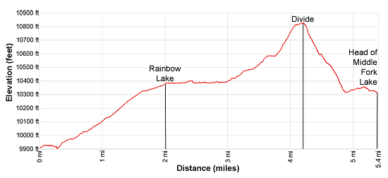
Distance: 5.4 miles (one way)
Bridger Wilderness, Bridger-Teton National Forest, near Big Sandy in Wyoming's Wind River Range
By: Diane Greer
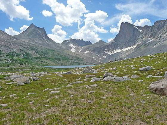
Lee Lake lies nestled in the bowl below the cirque
- Distance: 5.4 miles
- Elevation: 9,920-ft. at Junction Rainbow Lake Trail
10,369-ft. at Rainbow Lake
10,835-ft. at the Saddle above Middle Fork Lake
10,252-ft. at Middle Fork Lake
Lee Lake (10,305-ft.) - Difficulty: strenuous
- Basecamp: Big Sandy / Elkhart Park
- Region: Wyoming's Wind River Range
Middle Fork Lake via the Rainbow Lake Trail Description
This trail travels up a pretty valley to beautiful Rainbow Lake. After skirting the west side of the lake a boot beaten path ascends to a scenic divide overlooking the Middle Fork Lake basin. From the divide the high peaks and ridges of the Continental Divide fill the skyline to the east. Beyond the divide the trail fades and hikers must plot an off-trail route down to the head of Middle Fork Lake (10,252-ft.). Here scenic campsite enjoys panoramic views of the Nylon and Pronghorn Peak anchoring the cirque at the head of the valley. Mt. Bonneville towers beyond the cirque. To the north are fine views of the high peaks around Photo Pass.
For variety, exit the Middle Fork valley via the trail traversing the northern and then western shores of Middle Fork Lake. At the foot of the lake the path descends along the Middle Fork of Boulder Creek to a junction with the Fremont Trail above the head of Sandpoint Lake (9,810-ft.). To complete the loop turn left (southeast) on the Fremont trail, cross the North Fork of Boulder Lake and then head southeast toward Dream Lake.
The trail to Rainbow Lake is located along the Fremont Trail. If heading north on the Fremont, the Rainbow Lake junction is a tenth of a mile beyond the crossing of the inlet stream feeding Dream Lake’s eastern arm.
After crossing of the inlet stream the Fremont trail climbs on easy grades along the backside of a rocky knoll rising above Dream Lake’s eastern shore. As you ascend, pass a small pond along the west (left) side of the trail. Near the head of the pond reach a signed junction where the Rainbow Lake trail branches right (north).
Turn right on the trail to Rainbow Lake. Follow the path as it travels through rocky meadows scattered with trees along the west side of the inlet stream for Dream Lake’s eastern arm. Along the way pass a few small ponds.
At 0.3 miles the trail crosses Dream Creek. Beyond the crossing the path curves to the right (northeast) and ascends on easy to moderate grades along the west side of a narrow valley. A small stream, lined with willow thickets, trickles through the meadows along the valley floor. Spruce-pine forests grow along the hillsides.
Initially Dragon Head Peak (12,295-ft.) dominates the view to the northeast. As you ascend, enjoy ever improving views to the northeast with Pronghorn Peak (12,388-ft.), Mount Bonneville (12,585-ft.) and Raid Peak (12,532-ft.) joining the scene.
At 2.0 miles arrive at Rainbow Lake (10,369-ft.). The steep rugged slopes of Peak 11,282 loom over the west side of the lake while Dragon Head Peak towers above the lake to the northeast. Kagevah Peak (12,127-ft.) and Odyssey Peak (12,062-ft.) rise beyond the ridge at the head of the valley. A nice campsite is located atop the peninsula at the foot of the lake.
Trails traverse the east and west shores to the head of the lake. I recommend the trail along the western shore, which is considerably shorter. The trail which skirts the south and then east sides of the lake is used by horseback riders wishing to avoid a boulder fields along the west side of the lake.
Head north on the trail along the western shore, which travels through meadows and willow thickets beneath the steep slopes of Peak 11,282. Near the head of the lake boulder fields will slow your progress.
Follow the path as it curves around the head of the lake. At 3.0 miles reach a creek spilling down a narrow valley at the northeast end of the lake. Turn left (northeast) and ascend a boot beaten path along the west side of the stream. The grade abates briefly at 3.3 miles as the trail passes to the right (east) of a pond. Ahead our goal is in sight, the small saddle on the ridge between Dragon Head and Peak 11,176 at the head of the valley.
Past the pond the climb resumes. Reach a bench at 3.6 miles. Here a pond lies nestled in the meadows atop the bench. Skirt the west side of the pond and then climb moderate steep grades to the saddle on the ridge. Enjoy ever improving views of Kagevah Peak as you cross the broad saddle clad in alpine meadows.
Reach the north side of the saddle at 4.2 miles. Below, the eastern end of massive Middle Fork Lake (10,252-ft.) sprawls across the floor of Middle Fork basin. Kagevah Peak, rising on the ridge along the Continental Divide, towers above the lake to the northeast.
The saddle is a great place to take a break and survey the area around the head of the lake. Beyond the divide the trail fades and hikers must plot an off-trail route down to the head of Middle Fork Lake.
Descend from the saddle, dropping steeply down talus slopes and then meadows, trying to avoid the worst of the willow thickets. (Note: Early in the season the upper section of the route is snow-covered.) As you descend, views open to Nylon Peak (12,392-ft.) and the Twin Lions at the head of the Middle Fork valley. The pyramid-shaped peak beyond is Mt. Lander (12,623-ft.). Odyssey, North Cleft (12,548-ft.) and South Cleft peaks dominate the view to the north.
Near the lakeshore views open to the incredible cirque at the head of the valley anchored by the distinctively-shaped Nylon Peak, to the east, and Pronghorn Peak, to the west. Mt. Bonneville towers beyond. Lee Lake (10,305-ft.) lies nestled in the bowl below the cirque.
Near the head of the lake spend some time looking for a campsite with premier views of the cirque at the head of the valley and high peaks rising around the Photo Pass area to the north. Large areas around the head of the lake are quite boggy. The best bet is to find a site that offers some protection is to look in the trees above the southwest end of the lake or amid the scattered trees and rocky knolls around the inlet stream. The exposed sites around Lee Lake feature amazing views but are not a good place to be during a storm.
To reach Lee Lake, plot a course through the meadows, trying to avoid the boggy areas. Alternatively, cross to the east side of the inlet stream and then head south along the east side of the stream to Lee Lake. The lake is located about 0.6 miles (one-way) from the head of Middle Fork Lake.
To reach the foot of Middle Fork Lake, cross to the east side of the Middle Fork’s inlet stream. Soon after crossing the inlet stream you should be able to pick-up a boot beaten path heading north/northwest, traversing the lake’s eastern and then northern shores to the foot of the lake. Total distance from the head of Middle Fork Lake to the foot of the lake is 1.9 miles. (For more information on this trail read the description of the Middle Fork Trail.)
Good campsites are located at the foot of the lake (near the outlet stream) on a bench above western shore. This is a popular area, so don’t expect solitude.
Return to Segment 3: Raid Lake to Middle Fork Junction above Sandpoint Lake
Go To Segment 4: Sandpoint Lake to Valley Lake Junction
Elevation Profile
Backpack Segments
- Introduction: Big Sandy to Elkhart Park via Fremont and Highline Trails
- Segment 1: Big Sandy to Marms Lake
- Segment 2: Marms Lake to Raid Lake
- --- Side Trip: Bonneville Lakes
- Segment 3: Raid Lake to Middle Fork Junction above Sandpoint Lake
- --- Side Trip: Middle Fork Lake Trail
- --- Side Trip: Middle Fork Lake via the Rainbow Lake Trail
- --- Side Trip: Photo Pass Trail
- Segment 4: Sandpoint Lake to Valley Lake Junction
- --- Side Trip: Europe Canyon and Pass
- Segment 5: Valley Lake Junction to North Fork Lake
- --- Side Trip: Hay Pass, the Golden Lakes and Fall Creek Pass
- Segment 6: North Fork Lake to Bell Lakes Junction
- Segment 7: Bell Lakes Junction to Pole Creek
- --- Side Trip: Cook and Wall Lakes
- Segment 8: Pole Creek to Little Seneca Lake
- Segment 9: Little Seneca Lake to Island Lake
- --- Side Trip: Titcomb Basin
- --- Side Trip: Indian Basin and Pass
- --- Side Trip: Island Lake Waterfall Hike
- Segment 10: Island Lake to Elkhart Park
Driving Directions to Big Sandy Trailhead
Big Sandy Trailhead: This popular trailhead is located in the southern Wind River Range next to the Big Sandy River.
Directions from Pinedale: From the intersection of Pine Street (US 191) and North Tyler Ave (the Pinedale Tourism office is located on the northeast corner) in Pinedale, WY, drive south on Highway 191 for 11.7 miles and then turn left (east) on WY-353. After 15.5 miles you will notice signs referring to the road as the Big Sandy-Elkhorn Road and after 18 miles the paved road will change to a good packed dirt/gravel surface.
Shortly after the pavement ends go straight through a junction, and drive south crossing the Big Sandy River (Buckskin Crossing). Follow the road for a total of 27.3 miles. Shortly after crossing the Big Sandy River you will reach a junction with the Lander Cutoff Road (the next junction). Turn left on the Lander Cutoff Road. There is a wood sign at the intersection pointing toward the Big Sandy trailhead.
Drive 7.0 miles on the Lander Cutoff Road and then turn left on the Big Sandy Opening Road. Here you will see a sign for the Big Sandy Campground and trailhead. The road now deteriorates and narrows. Blind corners and lush foliage along the road make it hard to see ahead. Drive carefully, following the rocky, rutted road for 9.8 miles to a "Y" intersection. Bear right at the intersection to continue along the Big Sandy Opening Road (Forest Service Road 850). (The road branching to the left leads to the Big Sandy Lodge and Mud Lake.) Follow the road for 0.8 miles to the trailhead parking area, equipped with an outhouse.
Allow an hour and a half to reach the trailhead from Pinedale. The parking area is too small for the number of backpackers visiting the area during the height of the summer. If the parking area is full, find a safe place to park off the access road.
I recommend a high clearance vehicle to reach the trailhead. Passenger cars can make it OK if driven carefully. Check at the Pinedale ranger station before starting your trip to learn about current road and trail conditions. The Ranger Station is located to the east of the Ridleys Grocery Store on US 191 (Pine Street in Pinedale). The entrance to the ranger station is on the Fremont Lake Road. (You can also reach the parking area for the ranger station by driving east through the Ridley’s parking lot.)
This trailhead is remote, so be sure to have a full tank of gas. The dirt road become slippery when wet. The campground at the parking area is tiny, with only 4 sites. I would not plan on camping at the trailhead before starting your backpack.
Elkhart Park Trailhead: From the intersection of Pine Street (US 191) and North Tyler Ave (the Pinedale Tourism office is located on the northeast corner) in Pinedale, WY, drive east on Highway 191 (East Pine Street) for 0.3 miles and bear left onto Fremont Lake Road. Follow this road for 14.3 miles and turn right into the large parking area for the Elkhart Park/Pole Creek Trailhead. After the first 3.0 miles the road will turn into Skyline Drive/Forest Service Road 370740. The trailhead is located at the northeast end of the parking lot between the outhouse and the trailhead kiosk. It should take about 25 minutes to drive the trailhead. The last section of the road has some holes and uneven spots.
Trail Resources
- Backpack Intro
- Segment Photo Gallery
- Segment Map
- Trailhead(s) Information: Big Sandy / Elkhart Park
- Region Information: Wyoming's Wind River Range
- Other Hiking Regions in: Wyoming