Backpack: New Fork-Doubletop-Palmer Loop
Segment 6: New Fork Park to New Fork Lakes Trailhead
Distance: 8.5 miles (one way)
Bridger Wilderness, Bridger-Teton National Forest, near New Fork Lakes in Wyoming's Wind River Range
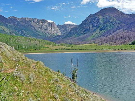
New Fork Lake and New Fork Canyon
- Distance: 8.5 miles
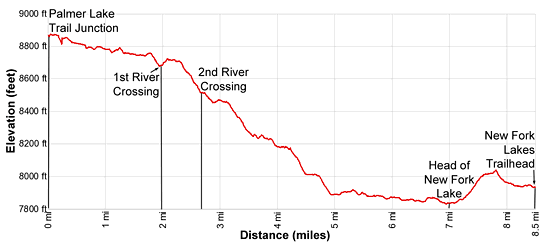
- Elevation: 0.0 miles at Palmer Lake Junction (8,880-ft.)
2.0 miles at 1st River Crossing (8,640-ft.)
2.7 miles at 2nd New Fork River Crossing (8,530-ft.)
6.4 miles at Junction Lowline/Doubletop Mtn. Trail
7.0 miles at Upper New Fork Lake (7.825-ft.)
8.5 miles at New Fork Lakes Trailhead (7,895-ft.) - Difficulty: moderate
- Basecamp: New Fork Lakes
- Region: Wyoming's Wind River Range
New Fork Park to New Fork Lakes Trailhead Description
From the head of New Fork Park and the junction with the Palmer Lake trail, the New Fork trail descends through pretty meadows and clusters of tree on easy grades for 1.7 miles. From the meadows enjoy dramatic views of pinnacles and spires topping the craggy walls of the Dome Peak massif, towering over 2,000-ft. above the west side of the park. The sheer walls of Peak 10,985 soar above the valley to the east. Campsites are sprinkled along the fringes of the park. Backpackers willing to cross the river will find some very nice sites along the east side of the valley.
At 2.0 miles the trail drops down to and crosses to the south side of the New Fork River. The ford is typically shin deep so be prepared for wading. The trail now climbs above the south side of the river and soon turns right (west). This is the point where the canyon makes a 90-degree turn. An overlook offers nice views of the high peaks rising above the head of New Fork Park to the north.
The trail now descends on moderate grades through the heart of New Fork Canyon, traveling through scattered trees set amid rock outcroppings and boulders. Along the way enjoy views of the cliffs and rugged crags of the Dome Peak (11,234-ft.) rising above the north side of the canyon. The rugged walls to the south, topped with towers and pinnacles, are scarred by numerous rock slides and avalanche chutes.
Cross back to the north side of the river at 2.7 miles. Beyond the crossing the descent continues on moderate grades. At 3.0 miles the grade abates briefly as the trail traverses a bench and curves away from the river. The descent resumes through open forest at 3.2 miles as the path detours around rocky knolls and then drops down to the a point above the river at 3.6 miles. Below the trail the river tumbles down a rocky gorge.
Here the trail travels through meadows set amid open forest on easy grades. Soon the path curves to the south/southwest and descends along a sinuous course through more open terrain, echoing the canyon’s twist and turns. Before long you will start seeing burnt trees, remnants of the 2008 New Fork fire.
At 4.5 miles the grade again eases as the canyon opens. A short distance beyond the trail curves to the right (northwest) and swings around then head of a marsh. Along the way pass a sign indicating you are leaving the Bridger Wilderness.
At 5.1 miles the path swings back to the left (southwest) and passes a few small ponds set amid soggy meadows. Beyond the marsh the trail continues down the northwest side of the valley. The New Fork River meanders down the willow-choked valley floor. The 2008 New Fork fire is responsible for the burnt slopes to the southeast.
At 6.4 miles reach a signed junction with the Doubletop Mountain Trail branching left (southeast) toward the Willow Creek trailhead. The sign is mislabeled. This is actually the Lowline Trail that leads to the Doubletop Mountain trail in 2.1 miles.
Arrive at the head of upper New Fork Lake at 6.9 miles. The path now begins an ascending traverse through grass and sage-clad slopes above the lakeshore. At 7.8 miles, after gaining about 200-ft., the path reaches at high point above the lakeshore. Here you have good views to the southwest of New Fork Narrows, the gap between the upper and lower lakes, along with distant vistas of the Wyoming Range.
The trail now descends on easy grades through grasses slopes sprinkled with sage that soon give way to Aspen forest, reaching the New Fork Lakes trailhead at 8.5 miles.
Return to Segment 5: Doubletop Mountain and Palmer Lake Trails
Go Back to Introduction: New Fork-Doubletop-Palmer Loop
Elevation Profile
Backpack Segments
- Introduction: New Fork-Doubletop-Palmer Loop
- Segment 1: New Fork Lakes to New Fork Park/Palmer Lake Trail Junction
- Segment 2: New Fork Park to Trail Creek Park via Lozier Lakes
- Segment 3: Highline Trail: Trail Creek Park to Elbow Lake Basin
- --- Side Trip: Peak Lake
- --- Side Trip: Jean Lakes Segment of the Highline Trail from Elbow Lake Basin to Island Lake
- Segment 4: Highline Trail: Elbow Lake Basin to Summit Lake
- Segment 5: Doubletop Mountain and Palmer Lake Trails
- Segment 6: New Fork Park to Trailhead
Driving Directions to New Fork Lakes Trailhead
New Fork Lakes Trailhead: Located on the northeast shore of Lower New Fork Lake, this trailhead offers an alternative and less crowded access point to the northwestern Wind River range without the long drive to Green River Lakes.
Directions from Pinedale: - From the intersection of Pine Street (US 191) and North Tyler Ave (the Pinedale Tourism office is located on the northeast corner) in Pinedale, WY, drive west on Highway 191 (West Pine Street) for 6 miles and then turn right on WY-352 toward Cora. Follow WY-352 for 14.3 miles and turn right on County Road 162, a dirt road signed for New Fork Lakes. Follow the road for 4.8 miles to the end of the road. Along the way the road name will change to New Fork Lakes Road/Forest Service Road 732/730. The New Forks Lake parking area is on the left. The trailhead is located at the northeast corner of the lot.
The 25.2 mile trip should take about 40 minutes. Passenger cars can typically make it to the trailhead without any problems.
Trail Resources
- Backpack Intro
- Segment Photo Gallery
- Segment Map
- Trailhead(s) Information: New Fork Lakes
- Region Information: Wyoming's Wind River Range
- Other Hiking Regions in: Wyoming