Details: Government to Big Man Panel 
Distance: 10.4 miles (round trip)
Grand Gulch Primitive Area, BLM, Monticello, Utah office, near Grand Gulch in Southeast Utah
By: Diane Greer
Hike Facts
- Distance: 10.4 miles (round trip)
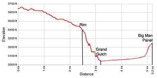
- Elevation: 5,650-ft. - 5,050-ft.
- Elevation Gain: -600-ft.
- Difficulty: moderate
- Trail Highlights: See Trail Intro
- Basecamp(s): Grand Gulch / Blanding
- Region: Southeast Utah
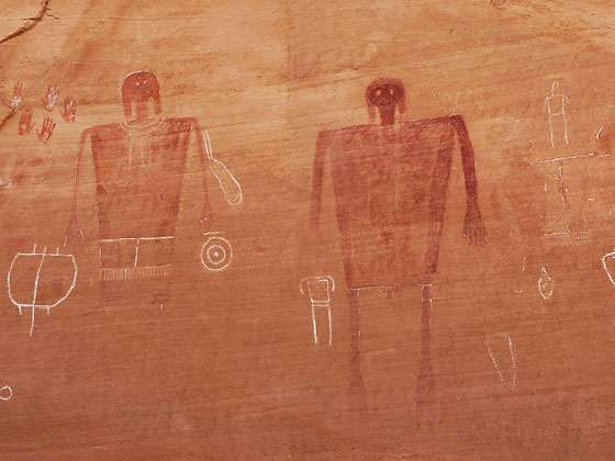
Two life-sized red and white pictographs, depicting a man and a woman, are the central focus of this fascinating rock art panel, located on a ledge high above Grand Gulch.
To Big Man Panel
The Government trailhead is located near a pond at the end of County Road #245, a dirt road reached from UT-261. (See driving directions below). From the parking area the trail heads north/northwest on easy grades across Cedar Mesa on along an old road, passing through scattered junipers, pinyon pines and scrub growth. Along the way enjoy views the Abajo Mountains and distant buttes to the north.
At 2.6 miles the trail reaches the rim of Grand Gulch where there is an old wood sign for Government trail. The rim offers great bird’s-eye-views into Grand Gulch. Directly across from the rim to the west is Polly’s Island.
Polly’s island was once part of a ridge that jutted out from the east side of Grand Gulch. The main channel of Grand Gulch use to go around the west and north sides of this ridge. At some point flood waters broke through the ridge, separating it from the canyon’s east wall. As a result the original channel became a dry meander (rincon), the end of the ridge became Polly’s Island, an isolated sandstone butte rising in the middle of Grand Gulch, and the main channel of Grand Gulch now runs around the south and east sides of Polly’s island.
Just below the rim of Polly’s island, sheltered by an overhang are ruins. Binoculars or a zoom lens of a camera will help you get a better view.
After taking in the views, follow the trail as it descends along slickrock ledges and rocky slopes down long, moderately steep switchbacks to the floor of Grand Gulch, losing over 300-ft in 0.6 miles.
Upon reaching the canyon floor at 3.2 miles, turn right (east) and follow the boot beaten paths up the wash. In a short distance the route along the wash turns north and heads up the broad wash along the east of Polly’s Island. Sections of the wash clad in slickrock contain pothole that may hold water in the spring or after rain/snow storms.
Reach the confluence of Polly’s Canyon (to the right/east) with Grand Gulch at 3.5 miles. A use-trail heads rights (east) up Polly’s canyon. During the spring in a typical year you may find water in the wash about 0.1 miles up the canyon. On dry years it may be necessary to walk much further up the canyon to Polly’s Spring, a seasonal, intermittent water source. This is a good place to fill water bottles before progressing further up Grand Gulch. During dry years you may not find water in Grand Gulch until you reach Step Canyon. Check with Kane Ranger Station before your trip to learn about the availability of water in Polly’s Canyon and further up Grand Gulch.
Backpackers will find a number of campsites near the confluence of Polly’s Canyon with Grand Gulch and further up Polly’s Canyon.
Beyond Polly’s Canyon the trail up Grand Gulch travels north along benches and then curves around a long ridge before resuming its northward march. Soon after passing a short east trending side canyon/bay at 4.8 miles leave the bench and drop into the wash. Walk another one-tenth of a mile up the wash, keeping an eye out for rock cairns along the east side of the trail marking the route to the Big Man Panel at 4.9 miles.
The use trail to the Big Man Panel, marked by rock cairns, ascends a steep slickrock ramp and then climbs steeply up a rocky slope to a ledge about 150-ft above the canyon floor. On the ledge follow the trail as it travels briefly north and then east to the panel, located on the north facing rock wall beneath an overhang. This amazing panel contains two huge anthropomorphs (human-like figures), a man and a woman, painted in red with white decorations. Other anthropopmorphs on the panel are outlined in white. There are also handprints and a few abstract forms.
From beneath the shady overhang enjoy great views to the northwest of Grand Gulch. After examining the rock art panel and taking in the view, retrace your steps to the trailhead.
This hike is best done in the spring and the fall. The hike along the mesa is completely exposed, offering not shade from the hot sun or protection in the event of a lightning storm. Be sure to carry plenty of water. Before starting the hike check on current road conditions and water availability at the Kane Gulch Ranger Station.
Day Hiking and Backpacking Permits for Cedar Mesa
Please note: Permits are required for hiking and backpacking in the canyons of Cedar Mesa, including Grand Gulch. Day use permits may be obtained at the Kane Gulch Ranger Station or at trailheads. During the spring and fall, overnight backpacking permits are only available at the Kane Gulch Ranger Station, and must be obtained on the morning of the trip. They may be reserved up to 90 days in advance by calling 435-587-1510. During other seasons, these permits may be obtained from the Monticello Field Office. See the BLM Grand Gulch website for more information.
Elevation Profile
Driving Directions
From Blanding, UT: Drive south on US 191 S for 4 miles and turn right (west) on UT-95 N. Follow UT-95 for 28.4 miles and turn left (south) on UT-261 S. Head south on UT 261 for 13.6 miles and turn right (west) on the dirt County Road #245/Slickhorn Road, located between mile posts 20 and 19. (The turn is directly across from the Cigarette Springs Road/County Road #239 and 9.7 miles south of the Kane Gulch Ranger Station.) Follow CR #245 for 2.6 miles to a “Y” intersection and bear right (west) staying on County Road #245. Follow the road for 4.9 miles to a signed “Y” intersection. Bear right (northwest) in the direction of the Government Trailhead. High clearance and 4WD vehicles can typically travel the final 1.5 miles to the trailhead parking area near a stock pond. Hikers with 2WD vehicles can usually travel about a half mile along the road before it gets too rough. At this point simply pull off the road at a good spot and park.
Trail Resources
Trail Intro / Trail Photo Gallery / Trail Map
Basecamp(s) Information:
Grand Gulch / Blanding
Region Information:
Southeast Utah
Other Hiking Regions in:
Utah