Backpack: New Fork-Peak-Elbow-Doubletop Loop
Segment 1: New Fork Trail: New Fork Lakes to New Fork Park
Distance: 8.5 miles (one way)
Bridger Wilderness, Bridger-Teton National Forest, near New Fork Lakes in Wyoming's Wind River Range
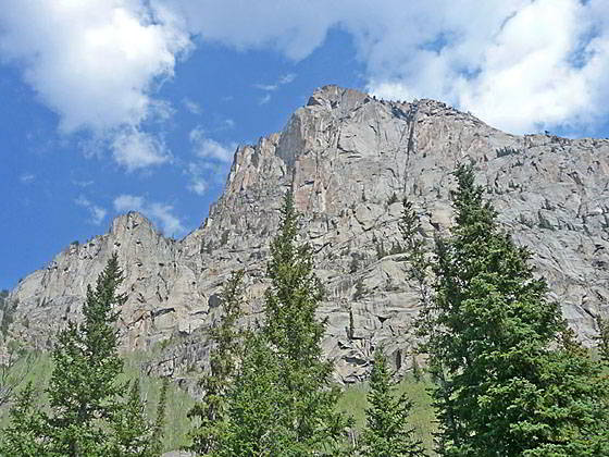
Sheer cliffs to the north of the trail
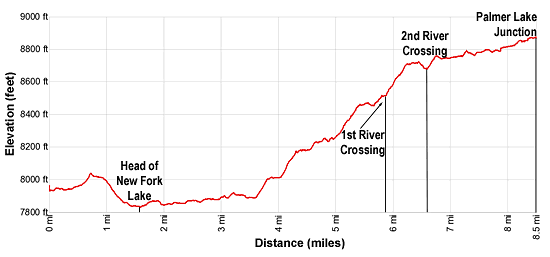
- Distance: 8.5 miles
- Elevation: 0.0 miles at New Fork Lakes Trailhead (7,895-ft.)
1.5 miles at Upper New Fork Lake (7.825-ft.)
2.1 miles at Junction Lowline/Doubletop Mtn. Trail (7,850-ft.)
5.8 miles at 1st New Fork River Crossing (8,530-ft.)
6.5 miles at 2nd River Crossing (8,640-ft.)
8.5 miles at Palmer Lake Junction (8,880-ft.) - Difficulty: moderate
- Basecamp: New Fork Lakes
- Region: Wyoming's Wind River Range
New Fork Trail: New Fork Lakes to New Fork Park Description
From the trailhead at the northeast end of the parking lot, head east through Aspen forest above the north side of the upper New Fork Lake (7,819-ft.). Soon the trees give way to grass- and sage-clad slopes as the trail ascends to the high point above the lake at 0.7 miles. Here you have good views to the southwest of New Fork Narrows, the gap between the upper and lower lakes, along with distant vistas of the Wyoming Range. The 2008 New Fork fire is responsible for the burnt slopes along the south side of the lake.
From the high point, a descending traverse along dry, exposed slopes is accompanied by ever improving views of the Dome Peak (11,234-ft.) massif and the cliffs bounding the lower reaches of New Fork Canyon. After losing about 200-ft. the path reaches the head of the lake at 1.5 miles where a sandy beach offers a nice place to take a break. On a sunny day this section of the trail is quite hot.
Beyond the lake an undulating path gently ascends through scrubby meadows along the northwest side of the New Fork Valley, offering nice views of the walls rising above the canyon ahead. The New Fork River meanders down the willow-choked valley floor. Twice I have seen moose grazing in the willows as I headed up the valley.
At 2.1 miles reach the junction signed for the Doubletop Mountain Trail branching right (southeast) toward the Willow Creek trailhead. The sign is mislabeled. This is actually the Lowline Trail that leads to the Doubletop Mountain trail in 2.1 miles. (The Doubletop trail can be used in conjunction with the Highline Trail to create a loop backpack out of New Fork Lake.) We continue straight ahead on the New Fork trail toward Porcupine Pass.
At 3.0 miles the path enters a section of the 2008 burn where there is a mix of burnt and live trees. Further along the trail travels above small ponds set amid a marsh.
Past the ponds the path curves right (southeast) around the head of the marsh at 3.5 miles and enters the Bridger Wilderness. Two short, moderate climbs follow. On the first climb the trail curves back to the left (northeast) as it ascends through trees and meadows. On the second ascent the trail curves around a ridge and enters the canyon at 4.25 miles. Below the trail the New Fork River tumbles down a rocky gorge.
The trail now follows the canyon’s twists and turns, traveling through trees and small meadows. As you proceed, the canyon grows more rugged with aspen and conifers growing amid rocky cliffs above the path.
At 4.6 miles the trail swings to the east and soon starts ascending on moderate grades, curving away from the river as it detours around rocky knolls. The grade abates at 5.3 miles as the path enters the narrowest part of the canyon. Ahead fine views open to the steep jagged cliffs of the Dome Peak massif towering above the north side of the canyon. The rugged walls along the south side of the canyon, topped with towers and pinnacles, are scarred by numerous rock slides and avalanche chutes.
The climbs resumes on moderate grades at 5.6 miles. Openings in the trees offer terrific views of the sheer climbs towering overhead.
At 5.8 miles the trail crosses to the south side of the river. Depending on conditions the crossing varies from knee deep to shin deep. On the south side of the river continue the moderate ascent through scattered trees set amid rock outcropping and boulders with ever improving views of the cliff and rugged crags of the Dome Peak massif.
At 6.3 miles the grade abates. Here the canyon makes a 90-degree curve to the left (north). From this vantage point views open to the high peaks tower above the head of New Fork Park.
The trail now curves to the left (north) and drops down to the second river crossing at 6.5 miles. The broad ford is typically shin deep. (Note: During periods of high water it is possible to avoid the two river crossings by plotting a route through the boulder fields along the north side of the river. I don’t advise taking this tedious route unless the river crossings are dangerous.)
Beyond the crossing the trail briefly climbs through trees and then heads north on easy grades up the west side of New Fork Park. Soon the trees thin, giving way to pretty meadows. From the meadows enjoy dramatic views of pinnacles and spires topping the craggy walls of the Dome Peak massif, towering over 2,000-ft. above the west side of the park. The sheer walls of Peak 10,985 soar above the valley to the east.
The easy 1.7 mile walk up the park meanders through meadows sprinkled with wildflowers and clusters of trees. Campsites are sprinkled along the fringes of the park. Backpackers willing to cross the river will find some very nice sites along the east side of the valley.
Near the head of the park the trail crosses Dodge Creek. The wide and typically shallow creek can normally be crossed without getting your feet wet.
At 8.5 miles reach the end of New Fork Park and a trail junction. Here the Palmer Lake trail branches right (east/southeast) while the continuation of the New Fork trail toward Porcupine Pass continues straight ahead (north). (See the Lozier Lakes description for information on the second half of the New Fork trail.)
Return to Introduction: New Fork-Peak-Elbow-Doubletop Loop
Go To Segment 2: New Fork Trail: New Fork Park to Trail Creek Park via Lozier Lakes
Elevation Profile
Backpack Segments
- Introduction: New Fork-Peak-Elbow-Doubletop Loop
- Segment 1: New Fork Trail: New Fork Lakes to New Fork Park/Palmer Lake Junction
- Segment 2: New Fork Trail: New Fork Park to Trail Creek Park via Lozier Lakes
- Segment 3: Trail Creek Park to Vista Pass, Peak Lake and Shannon Pass Junction
- --- Side Trip: Jean Lakes Basin
- Segment 4: Elbow Lake Basin to Summit Lake
- Segment 5: Summit Lake to New Fork Valley via Doubletop and Lowline Trails
- Segment 6: New Fork Valley to New Fork Lakes Trailhead (last 2.1 miles only)
Driving Directions to New Fork Lakes Trailhead
New Fork Lakes Trailhead: Located on the northeast shore of Lower New Fork Lake, this trailhead offers an alternative and less crowded access point to the northwestern Wind River range without the long drive to Green River Lakes.
Directions from Pinedale: From the intersection of Pine Street (US 191) and North Tyler Ave (the Pinedale Tourism office is located on the northeast corner) in Pinedale, WY, drive west on Highway 191 (West Pine Street) for 6 miles and then turn right on WY-352 toward Cora. Follow WY-352 for 14.3 miles and turn right on County Road 162, a dirt road signed for New Fork Lakes. Follow the road for 4.8 miles to the end of the road. Along the way the road name will change to New Fork Lakes Road/Forest Service Road 732/730. The New Forks Lake parking area is on the left. The trailhead is located at the northeast corner of the lot.
The 25.2 mile trip should take about 40 minutes. Passenger cars can typically make it to the trailhead without any problems.
Trail Resources
- Backpack Intro
- Segment Photo Gallery
- Segment Map
- Trailhead(s) Information: New Fork Lakes
- Region Information: Wyoming's Wind River Range
- Other Hiking Regions in: Wyoming