Backpack: New Fork-Peak-Elbow-Doubletop Loop
Segment 5: Doubletop Mountain/Low Line Trails
Distance: 12.0 miles (one way)
Bridger Wilderness, Bridger-Teton National Forest, near New Fork Lakes in Wyoming's Wind River Range
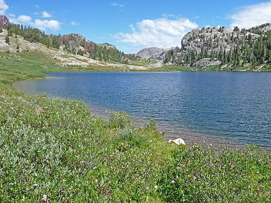
Palmer Lake
- Distance: 12.0 miles
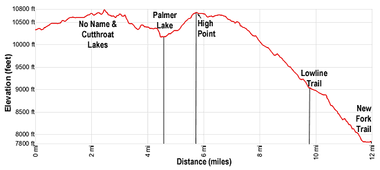
- Elevation: 0.0 miles at Summit Lake/Doubletop Mtn Junction (10,330-ft.)
1.2 miles at 1st No Name Lake (10,590-ft.)
2.0 miles at 2 nd No Name Lake (10,620-ft.)
2.5 miles at High Point on Ridge (10,780-ft.)
2.9 miles at Largest Cutthroat Lakes(10,595-ft.)
4.6 miles at Junction Palmer Lake and Doubletop Mtn Trails (10,180-ft.)
5.6 miles at High Point beyond Palmer Lake (10,720-ft.)
9.9 miles at Junction with Lowline Trail (9,020-ft.)
12.0 miles at Junction with New Fork Trail (7,850-ft.) - Difficulty: moderate
- Basecamp: New Fork Lakes
- Region: Wyoming's Wind River Range
Doubletop Mountain/Low Line Trails Description
The Doubletop Mountain Trail takes off from the Highline Trail at the signed junction along the western shore of Summit Lake. From the junction the Highline trail runs north to Three Forks Park and south toward Trapper Lake. We turn west on the Doubletop Mountain trail leading to Palmer Lake.
Follow the trail through meadows scattered with wildflowers, willow thickets and stunted conifers set amid rock outcroppings and small knobs. Views extend north to Glover Peak (12,068-ft.). Mount Oeneis (12,232-ft.) dominates the view to the east.
At 0.7 miles skirt the north side of a small tarn. Soon the trail crosses a tributary of Pine Creek three times, rock-hopping to the south side at 0.9 miles, the north side at 1.1 miles and the south side again at 1.2 miles. Just past the last crossing the trail reaches the foot (east end) of No Name Lake 10,590.
The path now traverses the south/southeast side of the lake. Turn around for fine views of Mount Oeneis along with Mount Whitecap (13,020-ft.), Split Mountain (13,155-ft.) and the other peaks rising above the Peak Lake area to the east/northeast.
At 2.0 miles reach No Name Lake 10,620, a pretty lake surrounded by lush meadows and rugged granite knolls. To the southeast views extend to Elbow Peak (11,948-ft.) and Harrower Peak (13,052-ft.). Scenic, albeit exposed, campsites are located around the No Name Lake basin.
Just beyond the foot of the lake the trail swings to the left (southwest) and climbs to the top of a ridge separating the No Name and Cutthroat Lake basins at 2.5 miles. Panoramic views from the ridge encompass a sea of high peaks to the east/southeast including Gannett Peak (13,809-ft.) rising between Ladd Peak (12,957-ft.) and Mount Whitecap, Split Mountain, Mt Woodrow Wilson (13,502-ft.), Mt. Oeneis, Bow Mountain (13,020-ft.), Sky Pilot Peak and Harrower Peak, to name a few. Glover Peak rises to the northeast.
Descend from the ridge on a rocky trail and then cross the inlet stream at the head of Lake 10,595, the largest of the Cutthroat Lakes, at 2.9 miles. The Cutthroat Lake basin, which extends south, features numerous small tarns cradled amid low knolls, rock outcroppings and clusters of stunted trees. More protected camping spots are dispersed about the basin’s nooks and crannies.
Travel a short distance along the lake’s western shore and then climb over two low ridges separated by a small basin with a tarn. The trail now descends on moderate grades through meadows scattered with trees, passing a tarn and then dropping down a rocky trail into a draw.
Reach the floor of the draw at 3.6 miles. Here the trail skirts the north side of a pond and then cross the pond’s inlet stream. Soon the trail climbs out of the draw, ascending through pretty meadows as it climbs to a bench atop a ridge.
The trail now curves to the northwest as it crosses the bench, traveling through small meadows, climbing over rock outcroppings and passing a few more tarns along the way. At 4.3 miles the trail curves north and briefly travels along the west side of a knob to an overlook above the Palmer Lake basin. Palmer Lake (10,163-ft.) lies nestled in meadows surrounded by rocky knolls scattered with trees. To the north a small section of the Palmer Cliffs are visible beyond a saddle on the ridge. Doubletop Mountain rises to the southwest.
From the overlook the trail briefly turns west as it drops steeply into the gully channeling Lake Creek and crosses the creek at 4.5 miles, just to the south of where the creek exits Palmer Lake. On the west side of Lake Creek ignore any trail branching to the left (south), instead bear right (north) and follow the trail traversing the slopes above the west side of Palmer Lake.
Reach an unmarked junction at 4.6 miles. Here we make a sharp turn to the left (south/southwest) on the continuation of the Doubletop Mountain Trail. The Palmer Lake trail continues straight ahead along the west side of Palmer Lake.
Past the junction the trail ascends south through meadows on moderate grades, reaching an unmarked junction at 4.7 miles. The trail to the left (south) is the Lake Creek Trail to Round Lake (9,956-ft.) and Section Corner Lake. We bear right at the junction on the Doubletop Mountain trail.
The path now swings to the southwest as it ascends around the south facing slopes of Doubletop Mountain (10,892-ft.) where small clusters of stunted conifers growing amid rock outcroppings. Views soon open to a panorama of high peaks to the east/southeast.
At 5.5 miles pass a second unmarked junction, branching left. This boot-beaten path leads to Round Lake and the Lake Creek Trail.
Reach the high point (10,720-ft.) along this section of the trail at 5.6 miles. A small tarn lies tucked in the meadows to the south. Here we enjoy great views of the high peaks along the Continental Divide to the east/southeast.
The path now heads west on easy grades, crossing a shallow draw at 6.1 miles. Here we pass another unmarked junction with an unmaintained trail branching left (south) to Indian Park. We continue traversing west, enjoying distant views of the Wind River Range to the southeast.
Soon the trail curves to the left (southwest) and drops below the timberline, descending on moderately-easy grades through meadows growing amid low knolls scattered with trees. The ascent briefly abates as the trail passes a pretty pond at 7.2 miles.
Beyond the pond the trail drops on moderate grades through trees and meadows to Rainbow Lake (10,190-ft.). Rugged cliffs rise above the lake’s western shore. Fishermen might want to stop and try their luck at catching some of the resident brook and rainbow trout.
The descent continues through forest to the pretty meadows of Martin Park. Campsites are located amid the trees rimming the meadows.
At 8.6 miles evidence of the 2008 New Fork fire, started by an abandoned campfire, begins to appear. Before long the trail begins dropping through scorched timber. A profusion of fireweed and a scattering of small trees/bushes grow between the charred logs and the dead standing tree trunks.
Reach the junction with the Lowline Trail at 9.9 miles. Here the Doubletop Mountain trail ends. We turn right (north/northwest) on the Lowline Trail toward New Fork Lakes. To the left the Lowline heads south, dropping 1,000-ft. on its way to the Willow Creek Guard Station.
The path now drops down the south slopes of the New Fork valley on steep switchbacks. The open, burnt slopes offer views the New Fork River meandering down the valley floor. The high ridges forming the walls of the New Fork Canyon tower above the valley to the north.
Upon reaching the valley floor the Lowline traverses meadows and then cuts a path through dense willows to a crossing of the New Fork River just before a prominent bend. Wade the river and then follow the trail through the willows to a junction with the New Fork trail at 12.0 miles. To return to civilization, turn left (southwest) on the New Fork trail and hike 2.1 miles to the New Fork Lakes trailhead. (See the New Fork Trail for more information.)
Return to Segment 4: Elbow Lake Basin to Summit Lake
Go To Segment 6: New Fork Valley to New Fork Lakes Trailhead (last 2.1 miles only)
Elevation Profile
Backpack Segments
- Introduction: New Fork-Peak-Elbow-Doubletop Loop
- Segment 1: New Fork Trail: New Fork Lakes to New Fork Park/Palmer Lake Junction
- Segment 2: New Fork Trail: New Fork Park to Trail Creek Park via Lozier Lakes
- Segment 3: Trail Creek Park to Vista Pass, Peak Lake and Shannon Pass Junction
- --- Side Trip: Jean Lakes Basin
- Segment 4: Elbow Lake Basin to Summit Lake
- Segment 5: Summit Lake to New Fork Valley via Doubletop and Lowline Trails
- Segment 6: New Fork Valley to New Fork Lakes Trailhead (last 2.1 miles only)
Driving Directions to New Fork Lakes Trailhead
New Fork Lakes Trailhead: Located on the northeast shore of Lower New Fork Lake, this trailhead offers an alternative and less crowded access point to the northwestern Wind River range without the long drive to Green River Lakes.
Directions from Pinedale: From the intersection of Pine Street (US 191) and North Tyler Ave (the Pinedale Tourism office is located on the northeast corner) in Pinedale, WY, drive west on Highway 191 (West Pine Street) for 6 miles and then turn right on WY-352 toward Cora. Follow WY-352 for 14.3 miles and turn right on County Road 162, a dirt road signed for New Fork Lakes. Follow the road for 4.8 miles to the end of the road. Along the way the road name will change to New Fork Lakes Road/Forest Service Road 732/730. The New Forks Lake parking area is on the left. The trailhead is located at the northeast corner of the lot.
The 25.2 mile trip should take about 40 minutes. Passenger cars can typically make it to the trailhead without any problems.
Trail Resources
- Backpack Intro
- Segment Photo Gallery
- Segment Map
- Trailhead(s) Information: New Fork Lakes
- Region Information: Wyoming's Wind River Range
- Other Hiking Regions in: Wyoming