Backpack: New Fork-Peak-Elbow-Doubletop Loop
Segment 2: New Fork Park to Trail Creek Park via Lozier
Distance: 9.7 miles (one way)
Bridger Wilderness, Bridger-Teton National Forest, near New Fork Lakes in Wyoming's Wind River Range
By: Diane Greer
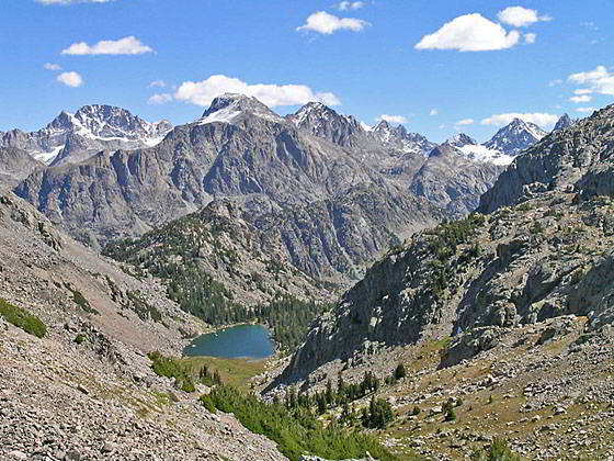
Clark Lake and the high peaks to the west
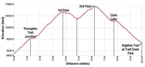
- Distance: 9.7 miles
- Elevation: 0.0 miles at Palmer Lake Junction (8,880-ft.)
3.7 miles at 1st Pass (10,680-ft.)
4.7 miles at Lower Lozier Lake (10,390-ft.)
6.1 miles at 2nd Pass (10,940-ft.)
7.5 miles at Clark Lake (10,270-ft.)
9.7 miles at Junction of Highline Trail at Trail Creek Park (9,300-ft.) - Difficulty: strenuous
- Basecamp: New Fork Lakes
- Region: Wyoming's Wind River Range
New Fork Park to Trail Creek Park via Lozier Description
This description, the continuation of the New Fork trail, starts at the trail junction at the head of New Fork Park, 8.5 miles from the New Fork trailhead. Here the Palmer Lake trail branches right (southeast). We continue straight ahead (north) on the New Fork trail toward Porcupine Pass.
Climb on moderate grades through trees and a few pocket meadows up the western slopes of the New Fork Valley. Openings offer views of Palmer Canyon to the southeast and the rugged peaks at the head of the valley
At 1.2 miles reach the junction with the Porcupine Trail, branching left (north/northwest). We bear right (northeast) on the New Fork trail toward Clark Lake. After a brief climb the grade eases as the trail traverses the slopes beneath Peak 11,290. Meadows along the path offer nice views of Rim Peak (10,985-ft.) rising above the confluence of Palmer and New Fork Canyons.
At 1.8 miles the climb resumes as the trail turns to the left (north) and ascends a series of moderate to moderately steep switchbacks up the west side of a tributary of the New Fork River. The climb is accompanied by great views of the high peaks towering above New Fork Park to the south.
The grade abates at 2.5 miles as the trail crosses the tributary in a rocky basin and then ascends the east side of a lovely little valley on moderate grades. Ahead views are dominated by rugged, unnamed 11,000-ft. peaks.
As you ascend the trees give way to rocky meadows. At 3.0 miles the trail turns to the east and continues climbing a few more switchbacks with fine views of New Fork Canyon to the south. Peak 11,290 towers above the trail to the west.
Soon after crossing a small stream at 3.3 miles the grade eases as the path climbs through a pretty basin and reaches an unnamed pass (10,680-ft.) near a small pond at 3.7 miles. As you crest the pass Kenny Lake, the largest of the Lozier Lakes nestled in a beautiful basin below the pass, springs into view. In the distance the high peaks in the northern Wind River Range, including Gannett Peak (13,809-ft.), Ladd Peak (12,957-ft.) and Mount Whitecap (13,020-ft.) along with a host of summits towering above the Peak Lake area and the head of Titcomb Basin, fill the skyline.
After taking in the views, follow the trail as it descends on easy grades from the pass, skirting the north side of Kenny Lake (10,590-ft.). Scenic campsites are located around the basin.
Cross the outlet stream at the foot of Kenny Lake at 4.1 miles. Soon the trail descends on moderate grades into a pretty basin and curves around the south side of lower Lozier Lake (10,390-ft.). The small lake is set amid meadows with scattered trees and surrounded by rugged walls.
Cross the lower lake’s outlet stream, the headwaters of the New Fork River, at 4.7 miles. Look south to see the walls marking the beginning of New Fork Canyon.
From the lower lake the path climbs through rocky meadows on moderate grades. As you gain elevation, turn around for nice views of the peaks rising above the Lozier Lake area. The Dome Peak (11,234-ft.) massif is seen through the gap formed by the New Fork Canyon.
At 5.4 miles the trail passes to the north of a small tarn and then climbs through a gap between polished granite outcroppings to a lovely basin above the timberline. Here an elongated tarn lies cradled in alpine meadows littered with rock outcroppings.
The path now ascends on moderately-easy grade along the north side of the basin and then climbs to the second pass (10,940-ft.) at 6.1 miles where a stunning panorama of high peaks unfolds. Desolation Peak (13,155-ft.), Rampart Peak (13,435-ft.) and Mount Koven (12,840-ft.) rise to the north of Gannett Peak (13,809-ft.) while nearer at hand Ladd Peak (12,975-ft.) and Mount Whitecap (13,020-ft.) dominates the scene. To the southwest Stroud Peak (12,825-ft.), Bow Mountain (13,020-ft.) and Twin Peaks (13,185-ft.) tower above the Peak Lake area. In the distance are views of Mount Helen (13,020-ft.) and Mount Sacagawea (13,569-ft.), to name a few. Behind you, to the west, are fine views of the peaks rising around the Lozier Lakes basin and the Dome Peak massif.
When you are done enjoying the breathtaking scene, descend the east side of the pass on moderately graded switchbacks through rocky meadows. Soon views open to Clark Lake. As you descend the trail zig-zags through rock slides and trees begin to appear along the path.
At 7.3 miles the grade abates as the trail reaches the Clark Lake basin. Here the trail skirts a cluster of trees and then travels along the south side of the basin to avoid soggy meadows along the valley floor, crossing a creek along the way.
Reach the west end of Clark Lake (10,270-ft.) at 7.5 miles after losing about 650-ft. from the pass. From this vantage point enjoy fine views of Stoud Peak, Bow Mountain, Twin Peaks, Mount Whitecap and Ladd Peak. Some scenic campsites are located beneath the trees around the basin.
The trail traverses the south side of the lake, crosses the outlet stream and then descends on moderate grades along the north side of the canyon channeling Clark Creek. At 8.0 miles the trail reaches a rock slide and swings to the right south, crossing the creek to detour around the slide. Soon the trail crosses back to the north side of the creek and then drops down a series of switchbacks. As you descend the trees thicken and you lose sight of the high peaks.
Cross Clark creek one more time before reaching a ford of Trail Creek at 9.6 miles. Late in the season you may be able to rock hop across the creek and keep your feet dry. Otherwise, take off your boots and wade Trail Creek, which varies from calf to shin deep. At 9.7 miles reach the junction with the Highline Trail. Turn left (north) at the intersection to reach Green River Lakes or right (south) to head toward Summit Lake.
Near the junction a use trail heads east to a nice camping area set amid meadows and clusters of trees. More campsites are found along Trail Creek. Remember to camp at least 100-ft. away from the creek.
Return to Segment 1: New Fork Trail: New Fork Lakes to New Fork Park/Palmer Lake Junction
Go To Segment 3: Trail Creek Park to Vista Pass, Peak Lake and Shannon Pass Junction
Elevation Profile
Backpack Segments
- Introduction: New Fork-Peak-Elbow-Doubletop Loop
- Segment 1: New Fork Trail: New Fork Lakes to New Fork Park/Palmer Lake Junction
- Segment 2: New Fork Trail: New Fork Park to Trail Creek Park via Lozier Lakes
- Segment 3: Trail Creek Park to Vista Pass, Peak Lake and Shannon Pass Junction
- --- Side Trip: Jean Lakes Basin
- Segment 4: Elbow Lake Basin to Summit Lake
- Segment 5: Summit Lake to New Fork Valley via Doubletop and Lowline Trails
- Segment 6: New Fork Valley to New Fork Lakes Trailhead (last 2.1 miles only)
Driving Directions to New Fork Lakes Trailhead
New Fork Lakes Trailhead: Located on the northeast shore of Lower New Fork Lake, this trailhead offers an alternative and less crowded access point to the northwestern Wind River range without the long drive to Green River Lakes.
Directions from Pinedale: From the intersection of Pine Street (US 191) and North Tyler Ave (the Pinedale Tourism office is located on the northeast corner) in Pinedale, WY, drive west on Highway 191 (West Pine Street) for 6 miles and then turn right on WY-352 toward Cora. Follow WY-352 for 14.3 miles and turn right on County Road 162, a dirt road signed for New Fork Lakes. Follow the road for 4.8 miles to the end of the road. Along the way the road name will change to New Fork Lakes Road/Forest Service Road 732/730. The New Forks Lake parking area is on the left. The trailhead is located at the northeast corner of the lot.
The 25.2 mile trip should take about 40 minutes. Passenger cars can typically make it to the trailhead without any problems.
Trail Resources
- Backpack Intro
- Segment Photo Gallery
- Segment Map
- Trailhead(s) Information: New Fork Lakes
- Region Information: Wyoming's Wind River Range
- Other Hiking Regions in: Wyoming