Backpack: New Fork-Peak-Elbow-Doubletop Loop
Side Trip: Elbow Lakes Basin to the Jean Lakes
Distance: 6.2 miles (one way)
Bridger Wilderness, Bridger-Teton National Forest, near New Fork Lakes in Wyoming's Wind River Range
By: Diane Greer
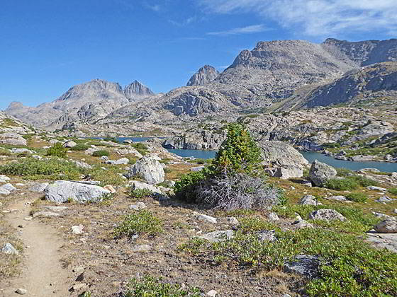
View of Stroud, Bow Mountain, Arrowhead Peak, G-17 and Peak 12450 from Lower Jean Lake
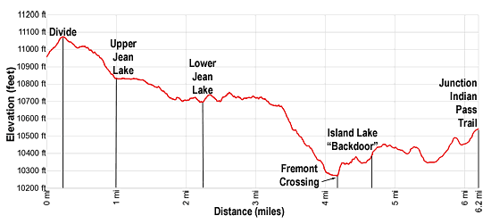
- Distance: 6.2 miles
- Elevation: 0.0 miles at Junction Shannon Pass Trail (10,950-ft.)
0.2 miles at Saddle (11,070-ft.)
1.0 miles at Upper Jean Lake (10,799-ft.)
2.2 miles at Lower Jean Lake (10,651-ft.)
4.1 miles at Fremont Crossing (10,250-ft.)
6.2 miles at Junction with Indian Pass Trail to Island Lake - Difficulty: moderate
- Basecamp: New Fork Lakes
- Region: Wyoming's Wind River Range
Elbow Lakes Basin to the Jean Lakes Description
This segment of the Highline Trail starts at the signed junction of the Highline Trail with the Shannon Pass Trail at the head of the Elbow Lake Basin. We turn right (southeast) on the south-bound Highline Trail toward the Jean Lakes. The Shannon Pass Trail, to the left (northwest), heads toward the pass and Peak Lake while the north bound Highline drops southwest through the Elbow Lakes Basin.
Follow the Highline as it climbs on moderate grades through meadows with fine views of Stroud Peak (12,198-ft.) and Mt. Oeneis (12,232-ft.) rising above Shannon Pass, the grassy saddle on the ridge to the northwest. Bow Mountain (13,020-ft.) dominates the view to the northeast. To the south Elbow Peak (12,948-ft.) and Sky Pilot Peak (12,129-ft.) tower above the Elbow Lake Basin.
At 0.2 miles reach the saddle (11,070-ft.) on the ridge separating the Elbow Creek and Fremont Creek drainages. Here views of Henderson Peak (13,115-ft.), the Titcomb Needles (12,710.ft-) and G-17 (12,814-ft.) fill the skyline to the east/southeast. Lake 10,935 lies nestled in the meadows below the saddle.
Descend from the saddle on moderate grades through meadows strewn with rocks and small boulders. At 0.5 miles the grades eases as you pass to the west of Lake 10,935. Mount Arrowhead Peak (12,972-ft.) and American Legion Peak (13,205-ft.) now join the impressive scene of peaks towering above the valley.
Beyond the lake a moderate descent, skirting the edge of a rock slide, leads to beautiful Upper Jean Lake (10,799-ft.) at 1.0 mile. The traverse above the lake’s western shore is accompanied by dramatic views of the peaks to the east. Scenic but exposed campsites are found above the lake’s southwestern shore and in the bowl to the northwest side of the lake.
Past the lake the trail travels along Fremont Creek, the outlet stream for Upper Jean. At 1.4 miles the valley narrows as the trail resumes its descent on moderately-easy grades down the west side of the creek. To the southeast are distance views of Mount Lester (12,342-ft.) and Mount Baldy (11,857-ft.).
At 1.75 miles pass a stream tumbling down a rocky chute along the east side of the valley. The stream emanates from Lake 11,665, located high above the valley in a bowl beneath Arrowhead, American Legion and Henderson Peaks.
The trail now descends on easy grades, crossing to the east side of the valley at 1.9 miles. Cross back to the west side of the creek at 2.2 miles, just before the stream enters Lower Jean Lake (10,651-ft.). Beyond the crossing the trail climbs above the lake and follows and undulating course high above the lake’s western shore, passing a few small tarns along the way.
Turn around for fine views up the Fremont Valley to Bow Mountain, Arrowhead Peak and G-17. Peak 12,450 and Peak 12,161 tower above the east/northeast side of Lower Jean. Mount Lester rises in the distance to the southeast.
For such a large lake there are surprisingly few campsites around Lower Jean. The challenge is finding a flat sites amid the steep, rocky terrain.
At 3.0 miles, near the foot of Lower Jean, the trail moves away from the lake and starts descending on easy grades, passing between two small lakes. Beyond the lakes the grade steepens as the trail drops down rocky meadows scattered with willows and trees, dodging boulders and rock outcroppings.
At 4.0 miles the grades eases as the trail swings around a basin dotted with tarns. Just before the trail reaches Fremont Crossing an unmarked route to Lost Lake heads west. A short section of the route is used to reach the Big Water Slide, a recommended side trip. The 1.0 miles round trip detour follows the Lost Lake route as it skirts the north side of a pond along Fremont Creek. At the west end of the pond the route turns south and crosses an inlet stream. Ignore any trails you see turning right (west). Instead continue along a boot beaten path heading south along the west side of the pond. The Big Water Slide is along the creek where it exits the pond. Here water gushes down polish granite ledges into a small poll. The scenic falls is a great place for lunch or a break before retracing your steps to the Highline.
Past the unmarked route to Lost Lake, the Highline trail reaches Fremont Crossing at 4.1 miles. The crossing is a lovely spot, set in pretty meadows scattered with trees and ice-polished knobs. To the north high summits including Bow Mountain, American Legion Peak and the Titcomb Needles grace the skyline. Nice campsites are located in the nearby basin.
A sturdy wood bridge, supported by steel girders, crosses the broad and fast moving creek. Beyond the bridge the trail makes a short, steep climb up the hillside above the south side of Fremont Creek. Soon the grade eases. The path now travels through meadows scattered with trees, climbing over low knolls, skirting granite outcroppings and passing a few small tarns tucked in rocky bowls. At 4.6 miles the path passes the unmarked junction of the [LINK] “Backdoor Route” into Island Lake. This route should only be attempted by hiker comfortable with off-trail travel and route finding.
Continue along the Highline as it briefly swings to the west and then back to the southeast along an undulating course that crosses several low knolls. At 5.0 miles views open to a small lake to the west of the trail.
Past the lake climb over a low rise and then descend into a basin with a pretty pond at 5.5 miles. Here views open to the high peaks rising to the west of the Island Lake including Fremont Peak (13,945-ft.), Jackson Peak (13,517-ft.), Elephant Head (12,180-ft.) and Harrower Peak (13,052-ft.).
At the south end of the pond the trail curves to the south, ascends along a draw and then crosses a rocky knoll into a second basin with another scenic pond. Cross the pond’s outlet stream at 5.9 miles. Behind you are more nice views of Fremont and Jackson Peaks.
The trail now skirts the west side of the pond and then climbs on moderate grades to a junction with the Indian Pass trail to Island Lake at 6.2 miles. To reach Island Lake turn left (northeast) at the junction onto the Indian Pass trail. Turn right (southwest) to continue along the Highline toward Little Seneca Lake.
Return to Segment 3: Trail Creek Park to Vista Pass, Peak Lake and Shannon Pass Junction
Go To Segment 4: Elbow Lake Basin to Summit Lake
Elevation Profile
Backpack Segments
- Introduction: New Fork-Peak-Elbow-Doubletop Loop
- Segment 1: New Fork Trail: New Fork Lakes to New Fork Park/Palmer Lake Junction
- Segment 2: New Fork Trail: New Fork Park to Trail Creek Park via Lozier Lakes
- Segment 3: Trail Creek Park to Vista Pass, Peak Lake and Shannon Pass Junction
- --- Side Trip: Jean Lakes Basin
- Segment 4: Elbow Lake Basin to Summit Lake
- Segment 5: Summit Lake to New Fork Valley via Doubletop and Lowline Trails
- Segment 6: New Fork Valley to New Fork Lakes Trailhead (last 2.1 miles only)
Driving Directions to New Fork Lakes Trailhead
New Fork Lakes Trailhead: Located on the northeast shore of Lower New Fork Lake, this trailhead offers an alternative and less crowded access point to the northwestern Wind River range without the long drive to Green River Lakes.
Directions from Pinedale: From the intersection of Pine Street (US 191) and North Tyler Ave (the Pinedale Tourism office is located on the northeast corner) in Pinedale, WY, drive west on Highway 191 (West Pine Street) for 6 miles and then turn right on WY-352 toward Cora. Follow WY-352 for 14.3 miles and turn right on County Road 162, a dirt road signed for New Fork Lakes. Follow the road for 4.8 miles to the end of the road. Along the way the road name will change to New Fork Lakes Road/Forest Service Road 732/730. The New Forks Lake parking area is on the left. The trailhead is located at the northeast corner of the lot.
The 25.2 mile trip should take about 40 minutes. Passenger cars can typically make it to the trailhead without any problems.
Trail Resources
- Backpack Intro
- Segment Photo Gallery
- Segment Map
- Trailhead(s) Information: New Fork Lakes
- Region Information: Wyoming's Wind River Range
- Other Hiking Regions in: Wyoming