Backpack: New Fork-Peak-Elbow-Doubletop Loop
Segment 4: Elbow Lake Basin to Summit Lake
Distance: 5.0 miles (one way)
Bridger Wilderness, Bridger-Teton National Forest, near New Fork Lakes in Wyoming's Wind River Range
By: Diane Greer
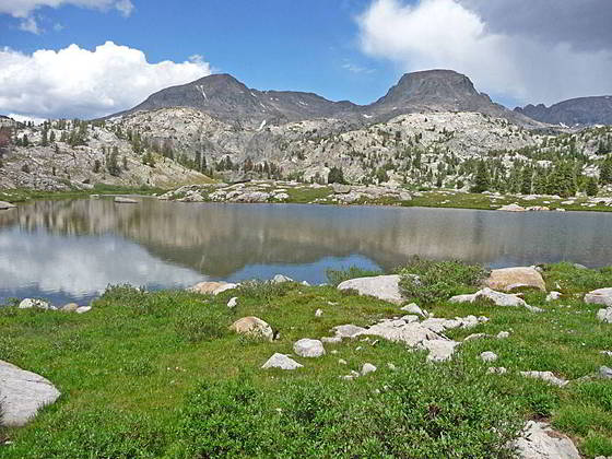
Sky Pilot Peak and Mt. Oeneis
- Distance: 5.0 miles
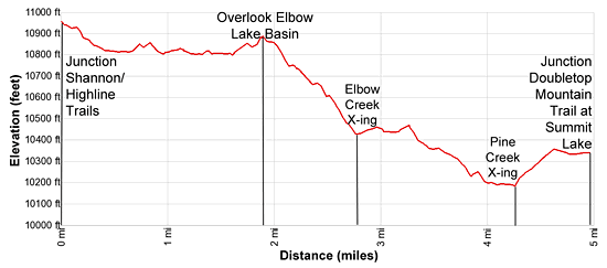
- Elevation: 0.0 miles at Junction Shannon Pass Trail (10,950-ft.>
1.9 miles at Elbow Lake Basin Overlook (10,880-ft.)
3.8 miles at Crossing of Elbow Creek (10,250-ft.)
4.25 miles at Crossing of Pine Creek (10,155-ft.)
5.0 mile at Junction Doubletop Mtn Trail at Summit Lake (10,330-ft.) - Difficulty: moderate
- Basecamp: New Fork Lakes / Elkhart Park
- Region: Wyoming's Wind River Range
Elbow Lake Basin to Summit Lake Description
From the junction of the Highline and Shannon Pass trails at the head of the Elbow Lake Basin, follow the Highline as it descends to the basin and then wanders through a stunning landscape of small meadows growing amid ice-polish rock outcroppings and erratic boulders. Massive Elbow Lake, along with a collection of smaller lakes and tarns, lie nestled in rocky bowls.
Bow Mountain (13,020-ft.), Mount Arrowhead (12,972-ft.), American Legion Peak (13,205-ft.) and Henderson Peak (13,115-ft.), along with the summits of the high peaks rising along the Continental Divide, dominate the view to the east. Mount Oeneis (12,232-ft.) and Sky Pilot Peak (12,129-ft.) tower above the basin to the north while Stoud Peak (12,198-ft.) and Mount Whitecap (13,020-ft.) are seen to the northwest. Elbow Peak (11,948-ft.) fills the skyline to the south.
At the foot of the basin the path climbs atop a knoll with a panoramic viewpoint (10,880-ft.) overlooking the Elbow Lake basin at 1.9 miles. Beyond the overlook the trail descends on moderate grades through rocky meadows to a shin-deep crossing of Eblow Creek. Late in the season you can keep your feet dry by rock-hopping across the channel. Here views open to Upper Twin Lake to the north where you will find a few nice campsites among the Whitebark Pines.
The trail now heads west, skirting the south side of a small tarn and then reaching the north end of Pass Lake (10,495-ft.) at 3.2 miles where it crosses the outlet stream. The path now curves to the right (north-northwest) as it climbs over a low knoll and then wanders by two small tarns set in meadows amid rocky knolls scattered with trees.
A short distance past the second tarn the trail descends steep switchback through trees to a wood bridge spanning Elbow Creek at 3.8 miles. The creek, draining Twin Lakes, tumbles down a gully choked with boulders.
The trail now follows an undulating course through trees to a crossing of Pine Creek at 4.25 miles. During periods of high water wade the creek. Otherwise keep your feet dry by rock-hopping across the stream.
Follow the trail as it ascends from the drainage and heads northwest. Soon the trees give way to meadows as the path crosses a minor stream and then climbs over a low rise where views open to Summit Lake (10,324-ft.), a shimmering expanse of water set amid meadows and surrounded by rugged peaks.
Reach the southwestern end of Summit Lake at 4.8 miles. Here you will see a trail heading right (east) along the lake’s southern shore. This trail leads to some scenic, albeit exposed, campsites above the east side of the lake. The trail now traverses the lake’s western shore. Pass a junction with a trail heading left (southwest) toward Trapper Lake at 4.9 miles. A short distance beyond reach the junction with the Doubletop Mountain trail, signed for Palmer Lake, at 5.0 miles.
Return to Segment 3: Trail Creek Park to Vista Pass, Peak Lake and Shannon Pass Junction
Go To Segment 5: Summit Lake to New Fork Valley via Doubletop and Lowline Trails
Elevation Profile
Backpack Segments
- Introduction: New Fork-Peak-Elbow-Doubletop Loop
- Segment 1: New Fork Trail: New Fork Lakes to New Fork Park/Palmer Lake Junction
- Segment 2: New Fork Trail: New Fork Park to Trail Creek Park via Lozier Lakes
- Segment 3: Trail Creek Park to Vista Pass, Peak Lake and Shannon Pass Junction
- --- Side Trip: Jean Lakes Basin
- Segment 4: Elbow Lake Basin to Summit Lake
- Segment 5: Summit Lake to New Fork Valley via Doubletop and Lowline Trails
- Segment 6: New Fork Valley to New Fork Lakes Trailhead (last 2.1 miles only)
Driving Directions to New Fork Lakes Trailhead
New Fork Lakes Trailhead: Located on the northeast shore of Lower New Fork Lake, this trailhead offers an alternative and less crowded access point to the northwestern Wind River range without the long drive to Green River Lakes.
Directions from Pinedale: From the intersection of Pine Street (US 191) and North Tyler Ave (the Pinedale Tourism office is located on the northeast corner) in Pinedale, WY, drive west on Highway 191 (West Pine Street) for 6 miles and then turn right on WY-352 toward Cora. Follow WY-352 for 14.3 miles and turn right on County Road 162, a dirt road signed for New Fork Lakes. Follow the road for 4.8 miles to the end of the road. Along the way the road name will change to New Fork Lakes Road/Forest Service Road 732/730. The New Forks Lake parking area is on the left. The trailhead is located at the northeast corner of the lot.
The 25.2 mile trip should take about 40 minutes. Passenger cars can typically make it to the trailhead without any problems.
Trail Resources
- Backpack Intro
- Segment Photo Gallery
- Segment Map
- Trailhead(s) Information: New Fork Lakes / Elkhart Park
- Region Information: Wyoming's Wind River Range
- Other Hiking Regions in: Wyoming