Backpack: New Fork-Peak-Elbow-Doubletop Loop 
Distance: 43.0 miles (loop)
Bridger Wilderness, Bridger-Teton National Forest, near New Fork Lakes in Wyoming's Wind River Range
By: Diane Greer
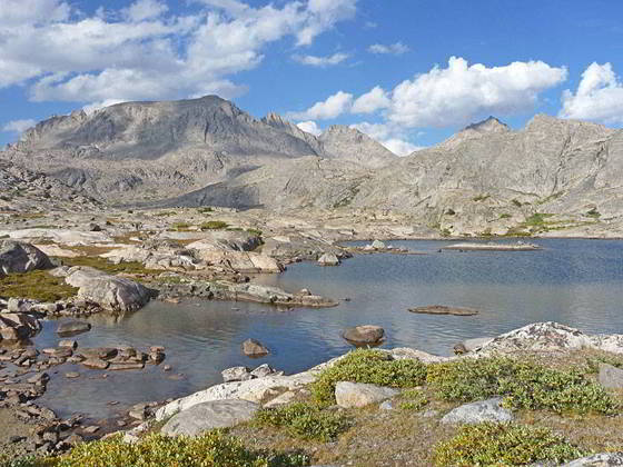
Elbow Lake
A dramatic canyon and five beautiful alpine lake basins set amid the high peaks of the northern Wind River Range are the highlights of this loop backpack out of the New Fork Lakes trailhead.
- Distance: 43.0 miles
- Elevation: 7,895-ft. at New Fork Lakes Trailhead
7.825-ft. at Upper New Fork Lake
7,850-ft. at Junction Lowline/Doubletop Mtn. Trail
8,530-ft. at 1st New Fork River Crossing
8,640-ft. at 2nd River Crossing
8,880-ft. at Palmer Lake Junction
10,680-ft. at 1st Lozier Lakes Pass
10,940-ft. at 2nd Lozier Lakes Pass
10,270-ft. at Clark Lake
9,300-ft. at Junction Highline Trail at Trail Creek Park 9,640-ft. at Junction Vista Pass Trail
10,160-ft. at Vista Pass
10,750-ft. at Cube Rock Pass
10,515-ft. at Peak Lake
11,160-ft. at Shannon Pass
10,950-ft. at Junction Highline/Shannon Pass Trails 10,880-ft. at Elbow Basin Overlook
10,330-ft. at Junction Doubletop Mtn Trail at Summit Lake
10,780-ft. at High Point on Ridge
10,180-ft. at Junction Palmer Lake Trail
10,720-ft. at High Point on Ridge
9,020-ft. at Junction with Lowline Trail
7,850-ft. at Junction with New Fork Trail
7,895-ft. at New Fork Lakes Trailhead - Difficulty: strenuous
- More Hikes in:
New Fork Lakes / Wyoming's Wind River Range
Introduction
This scenic backpack visits five stunning alpine lake basins; Lozier Lakes, Peak Lake, Elbow Lake, No Name and Cutthroat Lakes, on a strenuous loop out of New Fork Lakes. A 5.2 miles section of the trip is along the unmaintained Vista Pass trail that has been partially wiped out by a rock fall. Navigating the rock slide can be challenging and is only recommended for experienced parties. If in doubt, I recommend the slightly longer New Fork – Palmer – Doubletop trip which visits the five basins on well-defined trails.
The first segment of the backpack follows the New Fork Trail, which features dramatic views of the granite walls towering above New Fork Canyon and a delightful traverse of the beautiful meadows of New Fork Park. The park is a great place to spend your first night.
Beyond New Fork Park the path climbs to the lovely Lozier Lakes Basin and crosses two passes with stunning, panoramic views of the northern Wind’s high peaks, including Gannett Peak (13,809-ft.) - Wyoming’s highest summit. After cresting the second pass the trail drops down to Clark Lake and then to the Highline trail at Trail Creek Park, where nice campsites are set amid meadows and clusters of trees. Additional camping is found along Trail Creek.
From Trail Creek Park we follow the south-bound Highline Trail for 0.7 miles and then turn left (southeast) on the unmaintained Vista Pass trail. After crossing Vista Pass the path drops down to and then ascends along the Green River and soon ends at the base of a boulder field. The next half mile of the trail has been obliterated by a rock slide. Remnants of the trail and rock cairns help mark the route that ascends through talus. Many backpackers describe the climb up or down the rock fall using four letter terms.
Beyond the rock slide the trail turns east and crosses Cube Rock Pass and the drops down to a junction where a short spur trail leads to beautiful Peak Lake, nestled in a rugged bowl at the foot of a magnificent cirque of jagged peaks. After visiting Peak Lake, return to the junction and head southeast, crossing Shannon Pass to meet the Highline Trail at the head of magnificent Elbow Lake basin.
The trail now follows the northbound Highline through the basin, staying well above timberline as it traverses small meadows growing amid ice-polish rock outcroppings and erratic boulders. Massive Elbow Lake, along with a collection of smaller lakes and tarns, lie nestled in rocky bowls. Surrounding the basin is an amazing collection of 12,000-13,000-ft. peaks.
At the foot of the basin the trail descends through rocky meadows, wandering by small tarns and lakes set amid timber clad granite knolls. Along the way the trail drops down through trees to cross Elbow Creek and then Pine Creek. Beyond the Pine Creek Crossing the trail ascends to Summit Lake (10,324-ft.), a shimmering expanse of water set amid meadows and surrounded by rugged peaks.
At Summit Lake we turn west on the Doubletop Mountain trail, signed for Palmer Lake, which traverses the beautiful No Name and Cutthroat Lakes basins. A high ridge separating the two basins features panoramic views of the high peaks ranging from Gannett Peak to the summits towering above Titcomb and Indian Basins to the southeast.
Beyond the Cutthroat Lakes the trail travels through small basins scattered with tarns, rocky knolls and clusters of trees to Palmer Lake. Along the lake’s western shore, turn left (southwest) at an unmarked junction to stay on the Doubletop Mountain trail. The path now swings around the south facing slopes of Doubletop Mountain (10,892-ft.) and ascends to a high point (10,720-ft.) with stunning, albeit distant, views of the northern Wind River Range from Gannet Peak to high peaks rising above Indian Basin.
From the high point the trail descends through meadows and timber to a junction with the Lowline trail. Along the way the path enters the area burned during the 2008 New Fork Fire. At the junction turn right (north/northwest) and follow the Lowline Trail as it drops down burnt slopes on steep switchbacks to the floor of the New Fork Valley, crosses the New Fork River and then meet the New Fork Trail 2.1 miles from the trailhead.
Backpack Segments
- Segment 1: New Fork Trail: New Fork Lakes to New Fork Park/Palmer Lake Junction
- Segment 2: New Fork Trail: New Fork Park to Trail Creek Park via Lozier Lakes
- Segment 3: Trail Creek Park to Vista Pass, Peak Lake and Shannon Pass Junction
- --- Side Trip: Jean Lakes Basin
- Segment 4: Elbow Lake Basin to Summit Lake
- Segment 5: Summit Lake to New Fork Valley via Doubletop and Lowline Trails
- Segment 6: New Fork Valley to New Fork Lakes Trailhead (last 2.1 miles only)
Elevation Profile
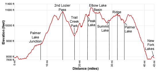
Mileage and Elevation Detail
| Miles | Elevation | Destination | |
|---|---|---|---|
| 0.0 | 7,895-ft. | New Fork Lakes Trailhead | |
| 1.5 | 7.825-ft. | Upper New Fork Lake | |
| 2.1 | 7,850-ft. | Junction Lowline/Doubletop Mtn. Trail | |
| 5.8 | 8,530-ft. | 1st New Fork River Crossing | |
| 6.5 | 8,640-ft. | 2nd River Crossing | |
| 8.5 | 8,880-ft. | Palmer Lake Junction | |
| 12.2 | 10,680-ft. | 1st Lozier Lakes Pass | |
| 14.6 | 10,940-ft. | 2nd Lozier Lakes Pass | |
| 23.1 | 10,270-ft. | Clark Lake | |
| 18.2 | 9,300-ft. | Junction Highline Trail at Trail Creek Park | |
| 18.9 | 9,640-ft. | Junction Vista Pass Trail | |
| 19.9 | 10,160-ft. | Vista Pass | |
| 21.9 | 10,750-ft. | Cube Rock Pass | |
| 22.3 | 10,515-ft. | Peak Lake | |
| 23.4 | 11,160-ft. | Shannon Pass | |
| 24.1 | 10,950-ft. | Junction Highline above Elbow Lake | |
| 26.0 | 10,880-ft. | Elbow Lake Basin Overlook | |
| 29.1 | 10,330-ft. | Junction Doubletop Mtn Trail at Summit Lake | |
| 33.7 | 10,180-ft. | Junction Palmer Lake/Doubletop Mtn Trails | |
| 34.7 | 10,720-ft. | High Point beyond Palmer Lake | |
| 9.9 | 9,020-ft. | Junction with Lowline Trail | |
| 39.0 | 9,020-ft. | Junction with Lowline Trail | |
| 41.0 | 7,850-ft. | Junction with New Fork Trail | |
| 43.0 | 7,895-ft. | New Fork Lakes Trailhead |
Trailhead Driving Directions
New Fork Lakes Trailhead: Located on the northeast shore of Lower New Fork Lake, this trailhead offers an alternative and less crowded access point to the northwestern Wind River range without the long drive to Green River Lakes.
Directions from Pinedale: From the intersection of Pine Street (US 191) and North Tyler Ave (the Pinedale Tourism office is located on the northeast corner) in Pinedale, WY, drive west on Highway 191 (West Pine Street) for 6 miles and then turn right on WY-352 toward Cora. Follow WY-352 for 14.3 miles and turn right on County Road 162, a dirt road signed for New Fork Lakes. Follow the road for 4.8 miles to the end of the road. Along the way the road name will change to New Fork Lakes Road/Forest Service Road 732/730. The New Forks Lake parking area is on the left. The trailhead is located at the northeast corner of the lot.
The 25.2 mile trip should take about 40 minutes. Passenger cars can typically make it to the trailhead without any problems.
Trail Resources
Trail Photo Gallery / Trail Map
Basecamp(s) Information:
New Fork Lakes
Region Information:
Wyoming's Wind River Range
Other Hiking Regions in:
Wyoming